mojorig
-
Posts
434 -
Joined
-
Last visited
-
Days Won
1
Content Type
Profiles
Forums
Blogs
Events
Articles
Video Feed
Gallery
Everything posted by mojorig
-
If anyone has any questions about this project, feel free to holler at me at jeremy.risley@agfc.ar.gov
-
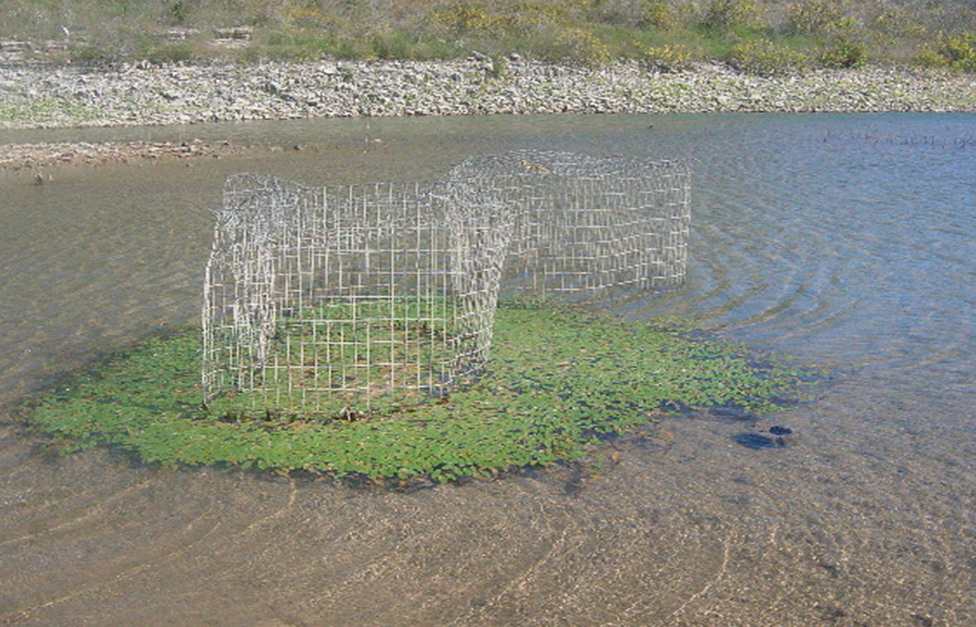
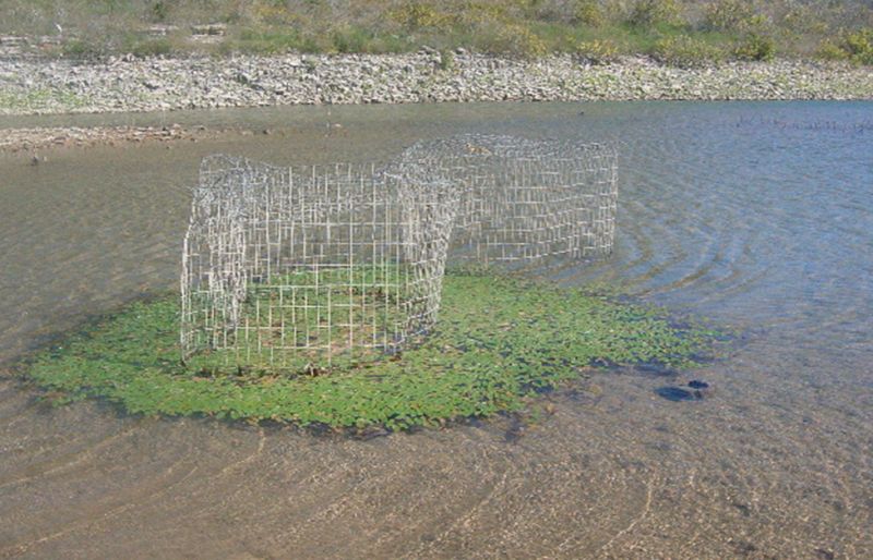
There was an effort to establish aquatic vegetation in Bull Shoals Lake by the AGFC in 2001. This effort did not include hydrilla but did include coontail and other native aquatic plants. The high water in 2008 pretty much killed the small amount of vegetation that was growing in the planting cages at that time. The project was abandoned by the AGFC several years later. Here is a short excerpt from a recent annual report talking about this effort: "In 2001, a project was started by the AGFC to establish aquatic vegetation in Bull Shoals Lake. Due to high water events and browsing by fish and turtles, the project failed to establish aquatic vegetation in the lake and was abandoned in 2010." Picture from 2004 of one of the planting cages on Bull Shoals Lake: Lake Ouachita was mentioned earlier. Hydrilla was once plentiful throughout that reservoir. Then sometime in the late 2000s, the hydrilla died back considerably. It is starting to come back in recent years but hasn't reached the level of coverage that it once was. Also, this year, the AGFC began a project to establish aquatic vegetation on Greers Ferry Lake. The results of that project could potentially drive an establishment effort on Beaver.
-
On the Waypoint transfer, there is a setting in the Garmin software that allows to you change the preferred files type from ADM to GPX. Once you do that, the Garmin will read GPX file directly from the SD card.
-
No, I received some data directly from the USACE and retrieved the rest from their monthly report listed on their website. Shot me a message with your email and I can send it to you.
-
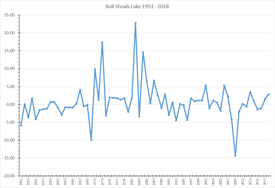
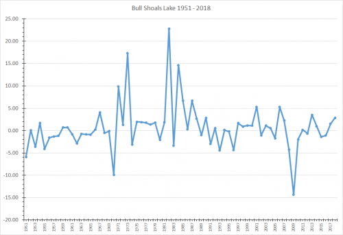
As requested, here is the Bull Shoals Lake data from 1951 to 2018. I took the Christmas Day water level minus the Thanksgiving Day level for each year. So this graph should be showing the increase or decrease in water level for the requested time period for these years. For example, in 1982, the water level rose 22.8 feet in that time period while in 2009, it decreased by 14.4 feet. To answer your question, it has happened four other times - 1971 (10 ft.), 1973 (17 ft.), 1982 (23 ft.), and 1984 (15 ft.).
-
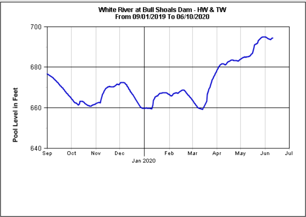
Here is the Bull Shoals Lake level during the same time period as the Newport gauge.

-
That is the only adjustment that I'm aware of in 1998.
-
I'm unaware of how lowering the Newport Gauge from 14 feet to 12 feet impacted the stages for the reservoirs. That would be interesting to see. I'll comb over Google to see if I can find something.
-
I found the following information from this link: How was the water control plan developed? When were the last changes made? back to topThis plan has a lengthy history. In 1942, the Basis of Design for Definite Project Report was developed, which included the original studies for the method of operation for Bull Shoals and Norfork. This report helped establish the size of the flood and conservation pools in each lake. In 1952, the Plan of Flood Regulation for Bull Shoals and Norfork Reservoirs was developed. This reports described the proposed plan of regulation for Bull Shoals and Norfork. In 1954, the Master Manual for Reservoir Regulation of the White River Basin was first developed. This described the operating criteria for Bull Shoals, Norfork, and Greers Ferry. In 1963, the Reservoir Regulation Manual for Beaver, Table Rock, Bull Shoals, and Norfork Reservoirs was developed. This was revised in 1966. In 1993, the Master Manual for Reservoir Regulation for White River Basin was developed. No changes to the Water Control Plan were made, only basin conditions were updated. The economic analysis showed that changing the allocation of storage for purposes other than flood control, hydropower, or water supply was not economically justified. In 1998, after years of additional study, a revision to the water control plan was made that lowered the regulating stages on the White River. Why not lower lake levels in the winter to prepare for spring rains? back to topWhile lowering lake levels in the winter to prepare for spring rains does in effect increase the size of the flood pool, at the same time it takes away from hydropower and water supply storage. The Corps does not have legal authority to do this. The current allocation of storage for flood damage reduction was approved by Congress. Changing that allocation would require Congressional action.Also, that is a very risky suggestion because there is no way to forecast long-range how much or how little rain will fall. If the Corps artificially lowered lake levels in the winter and spring rains did not come, a shortage of water to generate electricity, meet the needs of water utilities or provide viable recreation opportunities could ensue. The water supply and power users pay for that storage. If the drought progressed, instead of recovering, lake levels could continue to drop and cause an extreme water shortage. How can the Operating Plan be changed to improve conditions for me? back to topProposed changes to the operating plan would require authorization and funding by Congress to study the impacts. All user groups would have input on changes they desire, even though each change to benefit one group would have a negative impact on another group or groups. These impacts would need to be communicated to all stakeholders in the basin and a new plan developed and coordinated before it could be implemented. In the end, substantial changes in operations are unlikely because of the substantial impacts they would cause, and there is no way to predict the outcome of less significant changes (who wins, who loses).
-
Anglers and/or guides must catch their own shad within the same waterbody or they can purchase them through licensed bait dealer. There are guides on Ouachita, who are catching their own shad from the lake.
-
Here is an AGFC article about this issue: Click Here. There is an error in this article. Norfork Lake receives an annual Hybrid Striped Bass stocking except for this year. I will say from a personal standpoint that I wasn't thrilled about leaving north-central Arkansas, which at the time, had few cases of Covid-19 to go to an area that had much higher number of cases. I was prepared to do it but again I wasn't trilled about.
-
Binks mainly on fishes down on the lower end of the lake. Tom and Sean Reynolds are known to fish in MO starting in September through the fall.
-
Hound Dog is the way to go.
-
Here is a link to the AGFC survey Quillback is referring too: Click Here
-
Phil is correct that it doesn't appear they will be opening up Bull at this time. However, if they do at some point, I am not sure the protocol for warning anglers.
-
The "Old" normal was 654 ft-MSL. It already to 694 ft-MSL, this morning. It is still going to take a several inch rain to get it to 695 as that one foot difference is 4% of the total flood storage.
-
From the USACE - Little Rock Website: "Table Rock Dam’s spillway capacity was evaluated as a result of a dam safety program in the 1990’s. Using improved weather data and more modern technology and safety requirements, engineers determined that the lake would rise ten feet higher during the worst-case flood than previously calculated. An event of this magnitude would overtop the earthen embankment and destroy Table Rock Dam with catastrophic losses in downstream areas including Branson. To prevent the potential loss of life and property damages, congress approved and authorized construction of the Dam Safety Project. After considering several options and gathering considerable public input, an auxiliary spillway was determined to be the best solution. The auxiliary spillway was completed in 2005 at a cost of apx $65,000,000." Source:https://www.swl.usace.army.mil/Missions/Recreation/Lakes/Table-Rock-Lake/Dam-and-Lake-Information/
-
I would suspect flood gates will be open at Norfork Lake and likely Bull Shoals Lake by Monday. In fact, they have been cracked open at Norfork. I would, personally, consider finding somewhere else to fish under these conditions. https://www.ktlo.com/2020/05/22/corps-begins-spillway-release-on-lake-norfork/
-

23 Minutes ago. COE Evacuating Old 86 Park
mojorig replied to Bill Babler's topic in Table Rock Lake
We have been getting hammered in North-Central Arkansas all morning. -
We are seeing numerous, quality-sized Ozark Bass being caught this year. They are a really cool fish.
-
USACE is predicting Norfork to crest at 579.3.... that is before the endless rain predictions for the next week. So things are going to be interesting. I was wondering about all the floaters from the 2017 events that should now be free floating.... Just something else to dodge this weekend.😂😂
-
Ramps are open; however, with the current water level along with predicted levels, access/parking is going to be very limited. Launching at Bull Shoals Lake Boat Dock is possible but parking is very limited. You can also launch at Brown's Beach/Point Return Access is the city of Bull Shoals, Dam Site Access near the dam or Lakeview Ramp as well but again parking is going to be limited. I would say the Dam Site or Brown's Beach/Point Return will likely be your best opinions. Others may not agree.
-
Here is a link to the Water Control Plan that Devan S. is referring too. White River Water Control Plan Here is information from USACE that Phil posted in a recent post. " As you are aware, the lakes are high. The four-lake system is above 80% full and rising, with less than four feet of flood storage remaining for Beaver, Bull Shoals and Norfork. Downstream regulating stages are 10 feet above normal and rising as well. We currently have no plans to increase releases from the lakes. Doing so would require a deviation from the WCP and would be detrimental to our Flood Risk Management mission. This is the reason we have a surcharge pool. When rainfall occurs in the basin the runoff is estimated by the forecaster. When enough runoff is forecasted to fill the flood pool, the surcharge may begin. To get to a surcharge situation we would need around 1.5" above Beaver, 2" above Table Rock, 3" above Bull Shoals and 1" above Norfork.The current QPF estimate for Thursday - Tuesday is around 1.5" widespread. This would be enough to require Beaver and Norfork to spill somewhere around 10,000 cfs each depending on the timing and rate. This amount could also drive Table Rock within 0.5 foot of surcharge and Bull Shoals within 2 feet."
-
Phil, Are you receiving that update from Gabe?
-
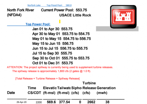
They have been having trouble with their turbines at several of the dams, so they have been using the spillway to release water. I suspect they updated their site to capture those releases in an effort to better describe the overall release rate occuring at each dam. The picture below shows how they had been handle the spillway releases. See the red message "ATTENTION: The project spillway is currently being used to supplement turbine releases. The spillway release is approximately 1,800 cfs (2 gates @ 1.0 ft). [Total Release = Turbine Release + Spillway Release]"