


Ben Gillispie
-
Posts
221 -
Joined
-
Last visited
-
Days Won
2
Content Type
Profiles
Forums
Blogs
Events
Articles
Video Feed
Gallery
Everything posted by Ben Gillispie
-
 Born and raised Taney County! Glad it is cool to someone else.
 -
Just an FYI that the Angler Spy (I just love saying that now that this is a real thing) units on TRL are now pulling weather information specific to the GPS coordinates of where they are located. It shows a small descriptor (i.e. 'Partly Cloudy', the current wind speed, and the most recent gust speed.) Thought this could be useful for both those of us who avoid the wind and those who chase those wind blown points like I've seen. Each location will show weather simply in text like so: Partly Cloudy, Feels like 64.0F Wind 0.0MPH (Gusts 0MPH) Anyways, just a friendly service announcement. Ben
-
Realtime Visibility, Temperatures and Elevation
Ben Gillispie replied to Ben Gillispie's topic in Table Rock Lake
Great to hear! -
Realtime Visibility, Temperatures and Elevation
Ben Gillispie replied to Ben Gillispie's topic in Table Rock Lake
Thanks Vernon! Just you wait and see, now that response is positive, I'm going to unleash all the tricks -
Realtime Visibility, Temperatures and Elevation
Ben Gillispie replied to Ben Gillispie's topic in Table Rock Lake
Yes, I am absolutely storing all data. Once there is enough to play with and I am satisfied with the interface, you will have access to it as well. Comparison, site specific, lakewide averages, once it is all there, it is just equations and making it possible for users to input their own queries. It is in the works. -
Realtime Visibility, Temperatures and Elevation
Ben Gillispie replied to Ben Gillispie's topic in Table Rock Lake
Until I get off work (lol), use Copy, then open a new tab (the two overlapping squares in bottom right corner of your Safari browser) then go to the address bar at top, long press it, click paste, hit Go in bottom right of keyboard. This will open the image directly. Saving it will allow you to examine also, but will take up space on your phone. The original images are large files, they are just scaled down for display for mobile responsive purposes and quicker load time. Ben -
Realtime Visibility, Temperatures and Elevation
Ben Gillispie replied to Ben Gillispie's topic in Table Rock Lake
Also, Mike, on your iPhone, try Long Pressing. It will bring up a menu where you can choose to Save, Copy, or, Open in New Window/Tab. This way you can pinch/zoom,etc. I am working on stream lining it so you don't have to switch tabs, but for now let me know if you get that working. -
Realtime Visibility, Temperatures and Elevation
Ben Gillispie replied to Ben Gillispie's topic in Table Rock Lake
Interesting stuff. I will put it on the 'for future research' list.... -
Realtime Visibility, Temperatures and Elevation
Ben Gillispie replied to Ben Gillispie's topic in Table Rock Lake
I'm working on this, Mike. I will keep you posted. -
Realtime Visibility, Temperatures and Elevation
Ben Gillispie replied to Ben Gillispie's topic in Table Rock Lake
Looking to invest??? -
Realtime Visibility, Temperatures and Elevation
Ben Gillispie replied to Ben Gillispie's topic in Table Rock Lake
Lake of the Ozarks is on my radar. TRL is my backyard, so this is the baby. I will continually improve and use TRL as the playground for new units, different sensors (DO and others, suggestions?). We are working on pulling in weather forecasts. Not that it will change significantly by any means from marina to marina around TRL, but if you were traveling or planning a trip, this could be useful to have it all in one place. Ben -
Realtime Visibility, Temperatures and Elevation
Ben Gillispie replied to Ben Gillispie's topic in Table Rock Lake
Ha. That would be a good plan I suppose! -
Realtime Visibility, Temperatures and Elevation
Ben Gillispie replied to Ben Gillispie's topic in Table Rock Lake
Mike, I'll make the images clickable so you are able to enlarge them. Excellent feedback as usual! Are you using it mostly on your phone/tablet/PC or all of the above? -
Realtime Visibility, Temperatures and Elevation
Ben Gillispie replied to Ben Gillispie's topic in Table Rock Lake
Then those are on the list my friend. -
Realtime Visibility, Temperatures and Elevation
Ben Gillispie replied to Ben Gillispie's topic in Table Rock Lake
Champ, thank you much for the kind words. Technology is indeed impressive, and such a playground. The possibilities are endless! -
Realtime Visibility, Temperatures and Elevation
Ben Gillispie replied to Ben Gillispie's topic in Table Rock Lake
What lakes do you fish @chi0082? -
Realtime Visibility, Temperatures and Elevation
Ben Gillispie replied to Ben Gillispie's topic in Table Rock Lake
Well, it is just sediment from the rains. There isn't really growth, it dusts right off. The process involves a complicated process whereby I take a gutter brush and clean then off ? -
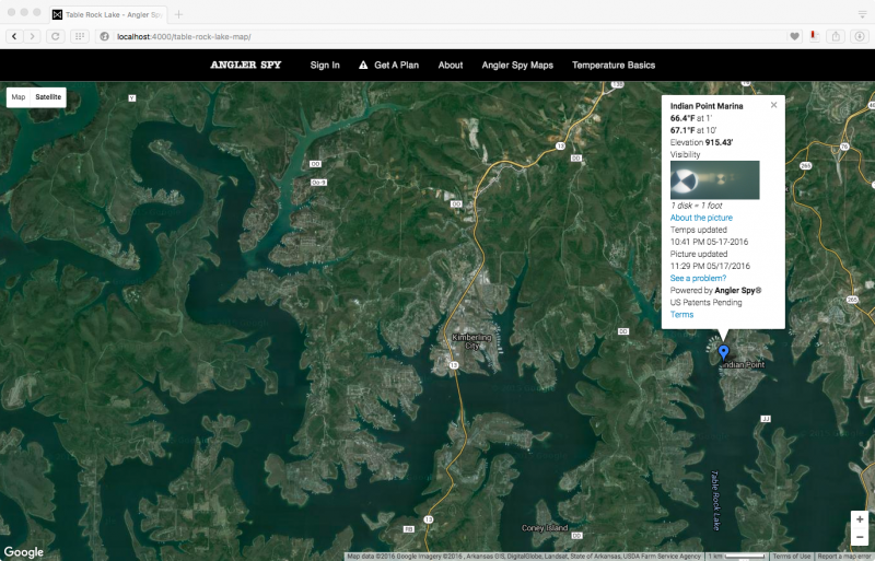
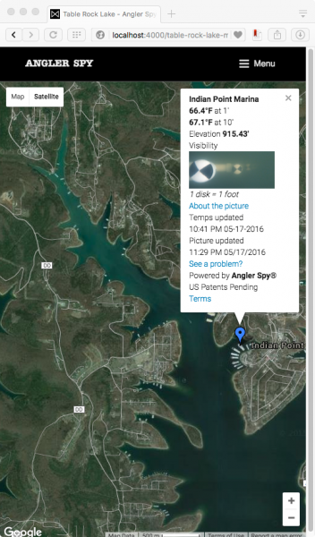
I am happy to introduce to you what I call Angler Spy™. This product I've been working on for the last 6 months features real-time, site-specific temperatures from two depths, pool elevation, and observed clarity. This is exclusive to subscribers of my new website. Currently, the service covers Table Rock Lake. We are currently branching out to include other area lakes. Here is what Angler Spy is all about: Real-Time Observed Visibility - Updated Daily - 1 disc = 1 foot of visibility. The first disc is 1' from the camera, each subsequent disc is 1' from the last. Two Temperature Readings - Updated Hourly - from depths of 1' and 10' Current Pool Elevation - Updated Hourly - from the U.S. Army Corps of Engineers gauges at Table Rock Dam Fully accessible on any device More depths, metrics, sites, historical data and lakes coming soon with your support! Currently, these units are at 6 area marinas: -Cricket Creek, State Park, Indian Point, Cape Fair, Kings River, and Holiday Island. Over time, Angler Spy will replace Table Rock Temperatures in order to focus time and energy on perfecting the art of Angler Spying and to improve and expand coverage. No, it is not free. No, it does not cost an arm and a leg! Yes, it costs less than 2 Whopper Ploppers from Tackle Warehouse for 3 months of unlimited, multi-device access. Learn more over at AnglerSpy.com Here is a visibility image from an Angler Spy unit located at Indian Point Marina taken today, May 18th, 2016. And below is an image from Holiday Island Marina taken today, May 18th, 2016. There is even a visitor.


-
HOURLY Water Temperatures Now Available
Ben Gillispie replied to Ben Gillispie's topic in Table Rock Lake
Yep, Phil is pretty covered by the USGS, as are most rivers. -
HOURLY Water Temperatures Now Available
Ben Gillispie replied to Ben Gillispie's topic in Table Rock Lake
Thanks, Phil. An honor, for sure! -
HOURLY Water Temperatures Now Available
Ben Gillispie replied to Ben Gillispie's topic in Table Rock Lake
Vernon, You are right! It was almost as if no one ever came in to actually ask if they could do something before..ha. So, I just stopped trying to ask and made sure to over do my electrical safe guards. They do a very good thing in my opinion, just a big, slow moving operation. Has to be that way I think! And yes, we are storing every reading from each sensor each hour in a database, so we'll be able to put together a nice playground of temperature data for historical, site comparison, averages, etc..should be neat to be able to see month over month, year over year, line chart of a time frame, etc. -
Hi guys and gals, Just letting you guys know that my site Table Rock Temperatures now has automatically updating temperature readings from (6) six sensors around Table Rock Lake with more on the way. These update every HOUR. Yes, every hour. Table Rock is a lake that can be so different from one area to the next, so I tried to get the main areas that, in my mind, represent different environments of the lake. There are temperature sensors at: Cricket Creek Marina State Park Marina Indian Point Marina Cape Fair Marina Kings River Marina Holiday Island Marina Next on the list is Long Creek Marina and Big M Marina. Apologies for any of you that may have begun to rely on my weekly updates as I have not been doing them for some time. I have been busy driving these Ozark hills, getting the OK from marina operators, getting blank stares from the Corps of Engineers, installing sensor equipment after hours, probably breathing too much solder smoke, and pecking away intently at the keyboard. I posted the original video about this project on 3 December, 2015 and haven't stopped since! Hope it serves you well. I've got another trick up my sleeve that I'll get up and live soon...it is a real treat. I'm grinning just thinking about it I promise it won't take six months! Ben
- 18 replies
-
- 10
-

-
Table Rock Water Temperatures 4-18-2016
Ben Gillispie replied to Ben Gillispie's topic in Table Rock Lake
Agreed, Mike. Onward I go -
All temperatures on the map have been updated today, April 18th, 2016. Things are starting to warm up out there. Good luck to everyone heading out this week! Click here for the map Ben
-
Thanks guys, looking forward to some reports coming in from this weekend. Ben


