


Conor
-
Posts
74 -
Joined
-
Last visited
Content Type
Profiles
Forums
Blogs
Events
Articles
Video Feed
Gallery
Everything posted by Conor
-
I got permission to use private property of some of my customers just upstream from EE. The property is not far upstream from the Hwy EE slab where we were able to pass using one of the culverts. The first 5 miles from the start to Hwy B was nice but nothing spectacular as far as scenery goes. The water level at High Gate was about 95 cfs when we put on. I had always assumed the gauge was at the Hwy 68 bridge but it sure didn't seem like 95 cfs where we put on. I was thinking maybe 40cfs. Anyway, the gauge is on Hwy B and I would say that it was accurate by that point. It was pretty low and scrapey for the first bit although we didn't have to get out. Clear Creek not far below Hwy EE almost doubled the flow and water levels were not an issue from that point on. The gradient was high of course being this far up in the headwaters and had only a few slow sections that the Bourbeuse is known for. One of the guys measured it to Hwy B at about 5 miles on the dot using his phone. At this point we rescued a dog stranded, scared, cold, and hungry on an island of logs piled up against the bridge so that was good. We called the owner using the number on the tag and the dog was picked up quite far from home. The first 5 miles was nice but not something super spectacular. It was charming as the Bourbeuse often is but had several pastoral sections with no bluffs. The scenery and sportiness REALLY picks up after Hwy B. This segment was full of sporty riffles and scenic Roubidoux sandstone bluffs/overhangs. I always thought the Mint Spring to Tea segment took the cake for this but I am not sure. There was some really spectacular scenery and the gradient was definitely higher which makes sense this high in the watershed. I would have to say this is probably the most scenic 7 miles of the river I have experienced so far. Riffles were tricky and kept you on your toes! Water clarity was really good as far as the Bourbeuse goes. The riffles were nice and blue-green in color and deeper pools had more apparent turbidity of course with the depth of the river being greater and looking through more water. This 7 segment was really close behind the far upper Big Piney from Simmons Ford to Dog's Bluff as far as scenery and sportiness goes. If you want to best part, get someone to drop you off at Hwy B and carry down to the river. I am not sure if it is a good idea to park at this bridge although it is possible. We went back to make sure the dog had been picked up and it was. We did Redbird down last year and the section down to Mint Spring definitely slowed down after Redbird but it does pickup through that part and offers great scenery and decent gradient. The fellow with the GPS app indicated this was 12 miles in total from the start above Hwy EE to Redbird Rd. Conor
-
The Dirt Devil that appears to be possessed by the Devil did finally trip the circuit breaker or GFCI when it stopped running. You could tell it was really slowing down and am sure eventually windings in the motor melted and shorted out. I tried turning the breaker back on to see if the show would continue but it was apparently game over! The breaker wouldn't reset until the vacuum was unplugged. I seemed to keep going through outdoor GFCI outlets every few months so finally put in a standard outlet without GFCI and replaced the circuit breaker with a GFCI/breaker unit inside the panel. This seems to work great and not need replacement every few months. It is a sealed box but guess enough moisture gets inside that the GFCI doesn't like it. There was one time I picked up an older extension cord and felt a slight tingle. The breaker tripped immediately so I know it works. That cord went in the scrap pile to be recycled. Conor
-
Not good. I was asked to go on a search around Morse Mill on the Big for this a year or so ago but had something going on. Apparently the guy had jumped from a bridge in the area and was never seen again. The group that went didn't find him but he showed up on the first warm few days from what I remember hearing. That is definitely not a good story. Of course he did it when the dam was releasing lots of water. My most harrowing experience was actually on the Bourbeuse which is definitely the slowest river in the Ozarks, just not the upper part at higher water. We put on at Mint Spring and portaged the next low water crossing downstream. I was taking pictures and realized I was being sucked back into the pour over. Got the camera put away and was rolled over. Luckily it wasn't as bad as other low dams or crossings I have seen..... I only lost a stainless steel bottle full of water in that incident. It was barely buoyant since it was full so probably trapped under the roller. I wasn't going to go looking for it. Conor
-
That was my thought about the vacuum cleaner like 4 miles from the nearest power outlet. Why???? Then they had left all kinds of tents, sleeping bags, blankets, clothing, and other gear. Maybe they got run off and forced to move on short notice but no one picked up their stuff afterwards. Found a full box of Depends adult diapers at a couple of these sites within close proximity so maybe the same person.... The clothing was new with the tags still on it but one side was sun faded and bleached while the other was soaked with black mold. I just piled all this crap in the tents and hauled it to a dumpster. Also, why a WORKING mini refrigerator????? I guess it could have been on a boat dock or something and got taken away by a flood. There were some regular properties along that section and at least one camp nearby that looked like it might have been from a homeless person or squatter. Sometimes it is just household trash in black bags so I guess whatever people use up and throw away just ends up in the river. The Big River is unfortunately plagued with this problem, especially on the lower 30 miles or so. Yes, I have found knives, water bottles, and other valuable items as well. Paddles, PFDs, etc. are all common. I really do think the flaming vacuum cleaner takes the cake through! I am trying to upload a video of that but it is quite large. I missed the first part when it ignited but quickly grabbed my phone once I realized it was going to put on a good show! Conor 20180822_130927.mp4
-
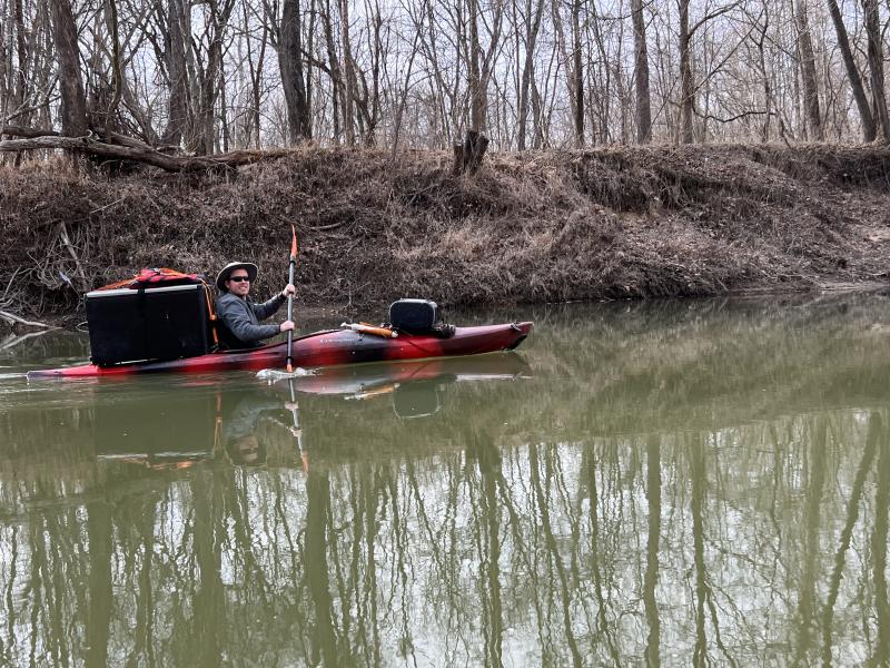
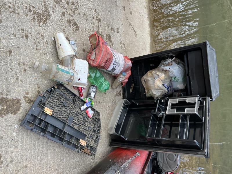
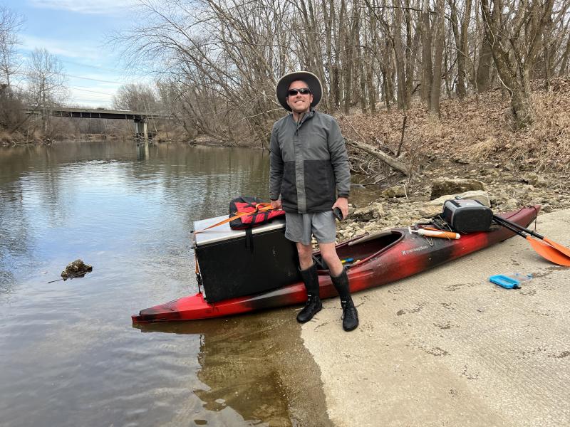
I always try to pickup some trash while out enjoying the rivers. Sometimes you find something useful such as a stainless steel water bottle or speaker along with the crap. What is the strangest thing you have found? Here are some of my contenders. -Flaming vacuum cleaner from old homeless camp. I plugged it in outside at home and the motor was frozen up. It caught fire right as it started to free up and put on quite a show for a couple minutes before it melted down in and inferno! That has to be my first choice for the strangest trash found. I have video of the best part as the thing really put on a show! -WORKING mini fridge. This is like one of the 3.2 cubic ft ones and I was able to get it down the river on my kayak with straps and some creativity. It didn't look to be in terrible shape and I set it upright for a while and plugged it in when I got home. I didn't put on a show like the vacuum but definitely works. The freezer part had frost after leaving it on for a couple hours. -Headless Santa -Halloween skeleton decoration -Wilson, as seen in "Castaway". -TWO meth labs unfortunately..... One was a propane tank discolored by ammonia and the other a gatorade bottle filled with noxious crap. Unfortunately I was just dumping out the contents to reduce weight and they went right in the river. I was greeted with some of the nastiest fumes you have ever smelled. I was unaware of what these were until after I picked them up. Luckily there was a cop at the river access with the propane tank so I told him about it. -One drug needle in a remote area along the Big Piney. I am surprised I haven't found more of these. -Dumped household goods like someone got kicked out of their house. I found tools, DVDs, baby pictures, home movies, and about 100x votive candles at a Meramec access. I found this another time near Ft. Leonard Wood so don't know if someone got deployed or kicked out of their house. -Several propane tanks which I used as trade ins. I made sure they weren't meth labs before picking up after that one incident. -Jacuzzi hot tub! I was unable to carry that one on a kayak but another group found out about it and removed it on 2-3 canoes like pontoons. This was a fullsize hot tub, not some dinky inflatable. -CANOE bent in half! It was one of these cheap platic Coleman ones but popped right back into shape and I towed it down the river. The aluminum bracing was busted in several locations but I repaired that and it seems to be a serviceable canoe with no leaks. -300lbs of jello shots, full cans of beer, water, airplane bottles, and other gear. This came from the destroyed canoe episode for sure and the canoe became a floating trash can to collect all the crap. -Kayak high above the banks in flood debris. -Smoking bongs and beer bongs, both on the Huzzah of course! Anyone else have some good ones to share? Conor
-
Yeah, I heard about Coles Landing and guess it was similar to what Mounts is like now. It is too bad this no longer exists because that would be a great intermediate point to use on a long 19+ mile section. Conor
-
I bet some of the fine sediments in this river are from the tiff as well. I don't think barite is as bad as lead but still not something you want a lot of in the river. Luckily it seems that this area has recovered pretty well since all that happened. As mentioned, it is amazing this river is as nice as it is with all the abuse it has had. I hear that one rapid is a pain so will be on the lookout to see if it is still there. I also understand there is some type of low-water bridge that must be portaged down from St. Francois State Park. Conor
-
Yes, all great info! Thanks! I assume the old borings probably continue down below Bone Hole a while as well. I had heard there was some sort of structure constructed along that stretch so this is good to know about. I guess eventually all the tailings will be stabilized or wash through the system but it will be many lifetimes. As mentioned, it is amazing the river is as nice as it is with all the abuse it has had. Unfortunately trash dumping has continued on this river so household trash, tires, appliances, etc. are still not uncommon. I did pull two old expired propane tanks out of the river and exchange them for new full ones. I paid $20 for the gas and got two $50 tanks free out of that deal! Conor
-
Someone interested in this subscribed to the online version of the newspaper for this area. There was an article in there saying these open boreholes should be capped. plugged, or grouted shut by 2021. Obviously that didn't happen. Conor
-
Thanks. I think the plan will be to make these day trips only. I guess a car would be safe parked in either of the state parks for an overnighter. That is the 19+ mile section so would be a good one to do and probably one of the more scenic of the 3 I mention. The converter theft and such seems to be a problem all over anymore. I have done 21.5 miles between Noser Mill and Rieker Ford on the Bourbeuse in a day and still have daylight to spare at the end so could do these all in a day. That is a slow river as we all know. If I were to camp overnight, I would make sure to be out of sight of any development and they would never know we were there after we were gone. Actually they might as we try to pickup as much trash as possible so it might look cleaner to them the next day. I don't think I would want to leave a car overnight at Browns Ford or Morse Mill. I haven't seen any nuts at Browns but Morse, Cedar Hill, etc. have some dandies. Some guy warned us about some crackheads at Cedar Hill once trying to rob him or something. He said he showed his 9mm and they were like "Go ahead and shoot us." Anyway, they started to come for us. I didn't want to have to repeat this with a .40 so we got everything just thrown in the truck willy nilly and the kayaks barely strapped in. We went like a mile down the road and got everything properly secured before getting on the highway. Conor
-
Thanks. This is all great info. I am amazed it took 10 years for the mines to fill but as you mention, they are HUGE. I saw several places were streams of water were pouring over the banks and wonder if there are pipes back there or springs that again started flowing once the mine filled. I think they still leave most equipment behind in mines but hopefully at least drain the fluids before doing so. I am also guessing that some of the far upper stretches of the Big River might not be impacted by lead. Is this correct or not? I am guessing somewhere below Mounts to Leadwood is where the impact from tailings and such starts. Apparently it gets really bad below Bone Hole on one of the sections I have yet to you. Your description of that area to St. Fran State Park isn't the most flattering but I still want to see it. Thanks again, Conor
-
I am looking at 3x long segments to complete the Big River. They are Bone Hole to St. Fran State Park. I don't expect this one to be all that great based on what I have been told and the aerial photos but want to do it. I wouldn't mind repeating something nicer like from Leadwood down and taking out before St. Fran, then going down to the St. Fran lower access. Then I have St. Fran to Washington State Park which is the longest I am looking at at over 19 miles. I have done distances like this but wouldn't mind splitting it up a bit. Then there is Browns Ford to Morse Mill. Are there any decent intermediate access points on these segments? I see some bridges mentioned as "poor" access points. I do not mind paying to use private property and would probably prefer it based on some of the nuts we have encountered at river accesses along the Big River. We have used Mounts twice and like that one. Conor
-
Many sites about the Meramec River watershed completely ignore the Big and Bourbeuse Rivers. The Big is the largest tributary by volume and I found reference to the Bourbeuse being the 2nd largest. I am not sure about that but maybe the AVERAGE is higher. It seems the Huzzah should be the 2nd biggest, especially down from the confluence of the Courtios. Anyway, these overlooked rivers are quite nice. The Bourbeuse has really grown on me as well. Conor
-
Thanks! I always like checking out new sections of river. The Big River is often overlooked because of its pollution and trash but I have found it to be quite enjoyable. I will never eat a fish out of it though! I found out that the boreholes are part of an old mine that has been allowed to flood. Apparently there is a confining layer that allows these to flow like this. The mine must slope/dip uphill from the river, allowing for artesian conditions to exist. Conor
-
Well, we found Bone Hole with no problems but thought the boreholes with flowing water were interesting. I assume they were just exploratory boreholes from the mining days that were left unplugged and now flow under artesian conditions. We saw several on the banks also one or two right at river level, spewing water like a geyser. There was also a larger diameter casing with an inner and outer casing. The outer casing was likely present to keep the unconsolidated materials from caving into the borehole above the bedrock. Conor
-
We found Bone Hole today with no issues. We did Mounts to Bone Hole and enjoyed it. The mining blight didn't seem bad, at least this time of year and we had no problems with crackheads or whatever. I could see suggestions of the tailings and "slime" you mention but it wasn't terrible, at least this time of year. It sounds like it is worse in the summer and downstream of this section. I thought this section was nice and definitely worth doing but do prefer the upper part from Hwy 21 to Mounts. I really think this is one of the best floats in the state at the right water level. The uncapped boreholes or artesian wells???? were interesting. I assume they were exploratory boreholes from the mining days that were left unplugged and now flow under artesian conditions. Conor
-
Thanks! It sounds like anything from Bone Hole to St. Francois State Park might best be skipped unless you do them in the colder months. Your description doesn't sound all that pleasant but I figure I should see it at least once. Yes, we put up about 2.5-3 miles above Cedar Creek at Hwy 21 so saw the area you talk about. I didn't see a ton of evidence of disturbance as it has recovered and enjoyed this part a lot. I would rank it as one of the best higher water floats in MO as it is fast, sporty, and scenic. We floated under the famous Iron Mountain Bridge and all. The put in was at Bootleg and the take out at Mounts. Yes, it is private with a $5 fee so we are happy someone is watching cars parked there. The part about Cedar Creek was nice but nothing out of this world. Think the Meramec around Woodson K Woods. The lower portion of this is worth another run for sure with really nice scenery and runs. It sounds like the section to Bone Hole is worth doing, then I will consider the next part another day or not. There are two long parts without access that I want to do including St. Fran to Washington State Park and Browns Ford to Morse Mill. The trash doesn't seem terrible down to Browns Ford although the Big River in general seems to have a lot of trash. Anything from Morse Mill down has LOTS of trash! I think the Morse Mill to Cedar Hill part is the worst section for this and the least scenic. I do like the other two and probably prefer Rockford to Times Beach even though you are floating amongst cars, tires, appliances, and discarded propane tanks. I pulled a propane tank out of the river and used it as a trade in core for a new filled one. Actually I have done this TWICE, both times on the Big River. I unknowingly pulled another out of the Meramec at Pacific but that was part of a meth lab. The Byrnesville section was neat as well and probably has the least trash of the lower 30 miles although it isn't exactly low on it either! I would assume all the trash starts somewhere above Morse Mill. This is probably the most abused river I have seen so far in MO. Some may have their share of trash such as the other more urbanized streams but it seems like the Big River is a special case. The Mineral Fork is not far behind on this but is scenic if you can arrange a private access point. The entire watershed is also a superfund site which probably doesn't really apply to most other rivers. I would definitely consider that portion through Leadwood but certainly don't expect anything super nice. I will just be connecting the dots and probably want to do this before the sun and heat activate the nastiness you describe. Conor
-
This is supposed to be a county park but I cannot find anything about the location. Several conflicting spots came up, some nowhere near the river! I think this is it but wanted to check. https://yellow.place/en/bone-hole-swimming-fishing-area-park-hills-usa We are thinking about doing Mounts (CR 511) to Bone Hole or about 10.2 miles according to what I have seen. The section above this is super nice and sporty at high flows. I know eventually you get into the old lead district where it isn't as scenic but want to eventually see it all. I have not been real disappointed in this river with maybe the exception of Morse Mill to Cedar Hill. This part and the rest of the last 30 miles or so is really full of trash. I probably prefer the last 10 miles the most of these sections even though it has lots of trash as well. Also, is this a safe access? I found news stories about crime and fights including a shooting. We ran into some real creeps at Cedar Hill as well. Conor
-
Access to and floating on Dry Fork of Upper Meramec???
Conor replied to Conor's topic in Meramec River
Interesting.... I remember reading somewhere that some of the water from the Meramec watershed might cross over into Welch Spring so wonder if maybe some of that water high up near Hwy 32 might be going that way as well. There are also a few small springs near Short Bend I have found so it could be coming back to the Meramec there as well. Conor -
This is another one of those headwaters/tributary streams that interests me. I am aware that the water goes underground so must be floated at high water much like the Dry Fork of the Meramec. I scoped this out during a high flow event and it looks like access at Plato would be easy. I was wanting to float this to Hwy 17 upstream of Ft. Leonard Wood (not Hwy 17 in downtown Waynesville lower down) and take out there. Has anyone here done this? How is the scenery and approximately what distance is it from Plato to Hwy 17? I assume this is mostly in the Roubidoux Sandstone and I have been impressed with other streams that have cut canyons into this formation such as the far upper Big Piney not too far from here and the Bourbeuse. That far upper Big Piney is very spectacular and was wondering if anyone here had done both stretches to compare them. I am talking about the part from Simmons Ford to Dog's Bluff in the Houston-Cabool area. Conor
-
Thanks. I assume you are talking about the crossing at https://www.google.com/maps/place/37°39'32.1"N+91°24'52.6"W/@37.6589081,-91.4168049,17z/data=!3m1!4b1!4m5!3m4!1s0x0:0x9f4a9e676918305d!8m2!3d37.6589039!4d-91.4146162 Also, since Hutchins Creek has more flow, how about using this spot? https://www.google.com/maps/place/37°40'17.6"N+91°23'39.0"W/@37.6715687,-91.3963415,17z/data=!3m1!4b1!4m5!3m4!1s0x0:0x94490cbff7451f5!8m2!3d37.6715645!4d-91.3941528 I may scope these two areas out next time I have a job down that way. I would probably consider going to Short Bend and no further on the first try. Conor
-
Access to and floating on Dry Fork of Upper Meramec???
Conor replied to Conor's topic in Meramec River
I have talked to someone who floated it and it sounds pretty nice if you can catch it right. It sounds like it has impressive sandstone bluffs similar or better so some of those along the Bourbeuse. Water quality also appears to be similar to the Bourbeuse. I was recently out driving Hwy 32 east of Salem and crossed the upper Meramec and something called Dry Valley or similar. Both were completely dry so I don't know if that water goes underground to the Current/Welch Spring or stays in the Meramec watershed. Conor -
Access to and floating on Dry Fork of Upper Meramec???
Conor replied to Conor's topic in Meramec River
Woodson to Scotts is only 9 miles. It isn't super slow but not super fast either. It picks up after the spring but slows down towards Scotts. I am talking about the Dry Fork and you are right that I might have to ask at private locations. I don't know if it would be OK to leave a car at a low water crossing. The Dry Fork comes in a little ways below the spring, then you could go on down to Scotts. Conor -
The first low water crossing upstream of Hwy 19 is covered in purple paint and signs.
-
Is it possible to put on above Short Bend without access to private property? I have driven some of the roads up that way and can see that the river is quite sporting in the extreme headwaters from the road. Has anyone ever put in above Hwy 19 and if so, how far and where? It looks like a couple creeks all come together up that way and maybe putting on at one of those creeks at higher water would work. Thanks, Conor


