bobber
-
Posts
550 -
Joined
-
Last visited
Content Type
Profiles
Forums
Blogs
Events
Articles
Video Feed
Gallery
Everything posted by bobber
-
we are floating the pruitt to hasty , (7miles) , or to carver(4) more makes it a 12 miler/ fishing is good ..but no big ones just a ton of 8 to 11 inch fish. sorry i posted so late .. hope it helps?
-
sounds like just what i'm looking for! shoot me a price ..
-
i'm looking for a small out board for a flatback canoe. not worried about looks but must run flawless! no fixer uppers wanted!
-
sorry, no lilly pads at all on the river start to finish. water is too low to float from ponca or steel creek.. but if you want to catch them ,.fish the root ball holes with the deep green colored water. small twister tails white, yellow, or brown 1/16th. sized jig heads ...........
-
My link
-

Search Under Way For Man Missing In Buffalo River
bobber replied to flytyer57's topic in Buffalo River
recovery was completed late on sat. evening .. -
Search Under Way For Man Missing In Buffalo River
bobber replied to flytyer57's topic in Buffalo River
still missing as of tonight sat./28 th. -
Search Under Way For Man Missing In Buffalo River
bobber replied to flytyer57's topic in Buffalo River
just got home, they have not recovered him as of 2;00 I did two 15 mile down stream run looking but the water is so muddy . and at the time the river was right at flood stage or maybe just under it . i just can't figure out why his friends watched him slip away down stream at 7:30 pm ? a very sad thing. these were non-boaters that drove down to the blue hole area. heading back in the morning but it's not looking good at all. -
Today about 11 am a large section of hill side slid off the top of the mountian and crashed in to the river below they had the river closed most of the day. it looked pretty spooky seeing how much slide off .
-
yeap! but if it's brown your out of luck ! it was clear down at pruitt. but the little buffalo was turning color @ DAVID, DID YOU SEE THE STRAINER TREE AT ERBIE?
-
12 inches of air space is beefy good water ! NOT SURE WHAT YOU MEAN ABOUT BUTT KICKIN' but it's fast and pushy (WARNING )there is a tree across the river @ erbie ...not sure if it's muddy brown water , might slow down the fishing?
-
watch what happens with the rain tonight .
-
everything changed easter weekend with the big flood event, in some parts the river channel move right to left. other spots it took out the middle . gravel bars washed away making camping a change from last year. had some mean strainers above the the erbie ford the park service has been cutting for days ........as for water levels around 23 inches of air space. and we move down stream to steel creek (this weekend) and as it drops we just keep moving down stream put ins.2 seasons ago gray rock was high up on the left back . now the river is moved so the water is pushing floaters back into it. some spots there isn't any gravel at all just boulders the size of grapefruits and bigger. hailstone is bad at low levels you can't miss the big rocks and it's a beat down run about half way your spent! and the tough stuff kicks your butt.the land scape is all together different than any other river i have been on. 16.5 miles of wicked white water. and you have to scout every bend some times twice ! lots of wood strainers, rock sives .and under cuts . we did it in a raft with 5 men and i was the guide. about 3 miles down from the put in we went over a pour over and the raft stopped dead! laughing at myself. i didn't stop. flew over the top of everyone slapping heads with my paddle as i went by. i landed about 15 ft. in front of the raft head first into a pool luckly it was deep water. we lost another guy under the raft as we walked a bad looking rapid. he stumbeled and was gone. the water pushed him belly first down the wash and under the raft. we pinned it twice and filled it to the top 4 times. at a low level 4.68 on the gauge. i don't want to go back anytime soon that's for sure!
-
back to fishing, the river is full of 10 to 15 inch fish .the problem is that on any given day 200 plus canoes splash by them. to have a better time you need to find a section less traveled. some spend all days in deep pools others fish the fast moving waters. crawdads are the main food along with river minnows. you don't see many big sun fish or cat fish but they have them.
-
IF YOU WANT GOOD DROPS. FROG @ RUDY OFF 540 OR CADRON NORTH OF CONWAY ON HWY 65 (TWO THUMBS UP )
-
ponca to kyles is the float of the buffalo! bar none it's a class II OZARK RUN it's best around 5 to 10 inches of air space . big wave trains in most rapids fast current you just steer paddling is'nt needed. crooked creek doesn't have the volume of water. but it's different it's creeky narrow and tree lined in high water there is no back to speak of. but the rapids are about the same in some of it .the parts i go to are just above lake harrison 10 to 15 miles private land we go in through cow pasture. and your talking about snow and the old highway kelly slab down yellville way ? right?
-
i have NEVER seen a jon boat that far up stream! but let me know where you pin it, and I will try to return whats left of it. fishing a white water section in a little jon boat? (it's a joke right?)... OK, let's say,if you make it past steel creek with out any problems as soon as you make that first bend to the left that big rock in the right side will high center you and you will fill up with water and sink before you can make it to the bank. and let's say you miss that one the next two sets of rapids will push you so hard to river right you will be knocked out by low limbs.... well so far you sank. and now are all bush wacked. and still have 8 more miles to go? hopefully you tied your gear down tight and haven't lost anything so far ? and let's just say you make it close to kyles the set of rapids above gray rock will for sure sink you ,just from the waves coming over the sides ,and front of the boat. and as the river pushes your boat under along with everything you tied down. swim to the bank on the right side and walk to the trail, it will leed you to kyles landing and we will bandage you up. do i need to go on to the next section? or have you had enough?
-
8.89 ft. on the st.joe gauge is fast water!
-
you need to call and check about the roads in. they were all closed due to the flooding most of them have big washouts and the road grader just did steel creek today, and was working down stream. i know rush is closed and maumee north.
-
http://www.facebook.com/photo.php?fbid=153530021380630&set=a.134484646618501.28066.132970643436568&type=1&ref=nf
-
photo.php slow week this is one we couldn't find! no wounder it was above the hiking trail
-
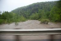
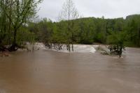
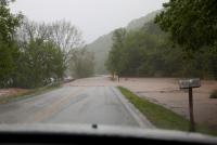
that's the ponca bridge under water. the other one is boxley bridge
-
please don't think i'm a thill seeker ! to me it's about safety first! that's why i took the time to get the training to be safe ........... but ,in that kind of water there only a handfull of people in the area that can do it > please don't make me do it again anytime soon!
-
the top pic is when we put on. the bottom is when we came off upper right is the ponca road it as 18 ft 5 hours later
-