Gene K
-
Posts
179 -
Joined
-
Last visited
Content Type
Profiles
Forums
Blogs
Events
Articles
Video Feed
Gallery
Everything posted by Gene K
-
Nice photos, Gavin - thanks for sharing.
-
It is not a designated county road. The owners can be found around there on occasion.
-
Not really. Ashley creek is about 1.35 miles from Baptist. Parker is a bit over 3 miles further downstream.
-
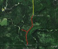
The yellow portion of the road is public access. The red portion is on private property. The portion that Y's off towards Ashley creek is gated and locked, private property. The red portion that runs to the area down stream of Ashley is also private property. Id do access the river from each location, but have permission from the owners. If you run into them, be courteous and ask. Where the yellow meets the red, there is also another trail that provides access even farther down stream. It's 100% public access (foot traffic only).
-
Yep, seriously. Going the back door I have made it in under 2:10, but I refuse to give details, as I am not sure of the statute of limitations, pleading the fifth and all that crap. Personally, I would never go Rolla unless I had a super model waiting for me there. But to each their own...
-
You are the mang! I couldn't make it from 44&270 in 2 hours driving a 600 hp sports car, driving like I stole it. And I have tried.
-
Naw, very fun - if in a 2 seater [thinking you meant 68]. Still not a believer - okay! Had to slow down for some deer, eh? NP, all in good fun. But one person was right about 68 (as I look back at past trips); Don't take someone down that road who is someone who is prone to motion sickness! P.S. - last time I took 72 was at 2:30 AM when the hurricane remnants came through a few years ago - mainly because we left from Salem hospital. Wife decided [okay, more like pushed by someone] to bust her head open at 2am. Talk about a long drive!
-
I drive this almost every weekend of the year. If I want to arrive 20 minutes later, I would take the Rolla route. 68 > 19 that is.
-
Neither. Take 68 at St. James to 19 to Salem and then west on 32 to 119 to the park (map link) Or... Take 68 at St. James to 19 (through Salem) to K to E to YY and in the back door to the Park.
-
CR 19-205 I think
-
Wear hunter orange!
-
Sounds reasonable to me, brownie. Once upon a time, about a month after I had a well drilled, the water suddenly became milky and stayed that way for months. Had to put a filtration thingy in. And just after that, all of a sudden it was clear and pure again. Had to be some portion of the uncased (albeit small) limestone falling apart.
-
There's a few (small), but if you are talking about this weekend the river level won't be helping with gravel bars. Below Baptist there are larger sand bars. FFM, naw - passing out in your car at Tan Vat just categorizes you as a safe driver.
-
Surely that was the Montauk gauge reading, and now it's higher. He was talking about near Eminence, so I bet down there the river is going to be really high and moving.
-
Yes, you are allowed to camp along the river and leave your car at Tan Vat. The sign is just for camping at Tan Vat.
-
bm, Actually, we call it Hidden Beach. On all the maps and Google Earth it shows up as the "S Turn."
-
Given that you will be there from Thursday - Saturday, and that we are in October now, I think camping at the beach at the S Turn would be a good bet. You can get there two different ways. A. You could park your car at the Parker access, wade across the river (knee deep) and follow the trail upstream. You will come to a spot where the river is in plain view and across the river from that spot is a large beach area. It's less than knee deep to cross over to that beach there. Going this way would be just over a half mile hike. And going this way there are a few other spots that you might decide are more fitting to you, but the S Turn area has a large beach area. B. This route would get you to the same spot without having to cross the river, but it's much longer, you can get lost if you don't know the route (it's not marked at all), or at least leave you wondering if you are going the right way. It would also require you finding a place to park your car other than Parker access, as it would be even longer. For instance, if you had to park your car at Parker access, the total hike distance would be close to 4 miles. If neither of those appeal to you, I can give you a few more ideas... Here's the hike from plan A from above: If you need directions on how to get to Parker let us know.
-
We were about a mile from the S Turn, and not on the stream.
-
Hear any bands where you were? j/k, we kept it down to a mild roar!
-
I think there are some places I would not care to leave my car. That said, given the right "trail-head," I think there are some possibilities of where he could leave his car. I feel sorry for anyone who might have been camping during that storm! I got down there just a few hours after it passed, and it was hard to even get down YY with all the trees down. No electricity for 7 days. 90 MPH winds that lasted for 40 minutes. Bizarre. More firewood laying around than all the boys in Perryville can sell!
-
I thought I posted something like that but I don't see it. Anyway... Yes, it's doable. What's the max distance you want to hike each way? No problem crossing the river during the hike? Yes, there can be somewhere safe to park the car. Just depends on where you start out. Yes, there are some good gravel bars that you can hike to. Others fishing Thursday and Friday would be minimal. Saturday probably see some.
-
Funny thread. A guy is PO'd because people share some information freely, thinking it hurts a fishery. Okay, it's his right to think that way. Everyone combined, if they were to share every single helpful piece of advice they could give, including specific geographic information and related fish populations/sizes, within this forum wouldn't do near the harm as some of the illegal activity that takes place from people who most likely never read this forum and probably never will.
-
Yea, I have NEVER received a reply to an e-mail I have sent them. I quit trying that route more than a year ago.
-
Did you complete and send in a commercial use application? I think that's the first step. You send that in and they send you back a packet of information. You can find the document here: http://www.nps.gov/ozar/parkmgmt/upload/OZ...Application.doc When you called did you call the Van Buren office (573) 323-4236?
-
Eagles Park - http://eaglespark.com/