


Conor
-
Posts
74 -
Joined
-
Last visited
Content Type
Profiles
Forums
Blogs
Events
Articles
Video Feed
Gallery
Everything posted by Conor
-
Some parts are not the most scenic. Overall I thought the part from Long to Davis Ford was well worth it. Davis down to Hazelgreen was nothing special but I didn't hate it either. It moved along nicely. I hear it isn't a good one in the summer as the scenery gets covered up. I will definitely try to figure out access up higher or plan to do an overnight and camp well above Evergreen. Conor
-
We went back and did Davis to Hazelgreen. The section from Long Ford to Davis is definitely the pick of these two. There was nothing wrong with the lower part but nothing special as mentioned by others either. I can see others here view this part like I view the Niangua around Bennett Spring. Pretty much every river of equal or closer distance to me is better than the section from Moon Valley to Barclay or so. I have done way high up on that river and enjoyed it and some of the scenery from Prosperine/Mountain Creek to Ha Ha Tonka is really nice but that part near the spring is nothing special compared to all what else is near me. The Meramec near the spring is close to me, the Current is close to me, and I can be at the upper Jacks Fork in similar time. The Eleven Point is just a few minutes farther. Again, that part of the Niangua isn't bad but when you have those other streams to compare it to, there is no comparison. Also, that section just needs to be avoided on a summer Saturday. That being said, I do plan to try and figure out a way to access the uppermost 30 miles. I can tell there is potential for some nice scenery. I guess I need to just get out and scope some of the water crossings upstream of Evergreen and see how they look, even if just getting dropped off or picked up. I would check cell phone signals at the same time so we could know if one could call for a ride when getting close to the end. Conor
-
Lambeth Ridge is still standing but closed to traffic. It is a thrill to get up there as some of the boards are missing or pretty rotted. I just made sure to stay over the beams below. Some of the beams are even made of timber which is strange. I am glad a few of these are still around but know it will only be a matter of time for most. I definitely think it is more scenic here in the winter. I have heard from others that they were not impressed with this stream so I guess I wasn't looking for much. It has some nice bluff lines, a pretty large heron rookery, and a couple very pretty springs. Overall the scenery was pleasant but I can imagine a lot of the good stuff being covered in summer. I always find the upper headwaters of streams to be most interesting. This includes places dozens of miles upstream of mile 0 on some streams. The upper Gasconade below Hartville has some great scenery but some longer pastoral sections as well. Catch it high and after a rain for the best scenery with some great waterfalls.... I suspect one could go higher on the forks above Hartville as well. There are several large tributaries downstream of there that look quite floatable too. I need to get out and scope Atlanta Rd. and Hwy J. I wonder if someone could be dropped off at Atlanta Rd. or not. I would assume leaving a car there is out of the question even if the Plasters aren't as bad as the old guy. Conor
-
I know this is an old thread but the upper Gasconade from Camp Branch to Wilbur Allen is pretty hard to beat. This is a high water float for sure but has a huge natural arch and more beautiful springs than you can count. You can cut it in two with the Buzzard Bluff Access as well. Once you get to the large natural arch 4 or so miles in, the scenery really picks up. I seem to recall it being around 20 miles total. We put in once below the spillway at Hartville but it was not worth the effort for the extra 3-4 miles. That distance was nice but nothing you cannot see elsewhere and there is effort in getting around the lake and dam. Conor
-
Well, I have been interested in this for years but have heard all the horror stories about the Plasters and the town of Evergreen which is essentially their little private kingdom. This is everything from them running folks off at gunpoint to lobbying to privatize float streams in MO. I had figured they likely had all the county Judges, Sheriff, etc. bought and paid for as well so best to just avoid it altogether which is probably what they want. Anyway, I am always looking to try new sections of river and have been impressed by far upper Roubidoux Creek, the far upper Gasconade, far upper Big Piney, and the Little Piney. To clarify, I am talking about the Little Piney that is a tributary of the far upper Big Piney in Texas County. If helps form the Narrows and flows in immediately upstream of Dog's Bluff. The Little Piney near Rolla is also a great stream. All of these drain the same plateau with similar geology so I figured that the Osage Fork would share similar types of scenery. I was pleasantly surprised when I started looking at the maps and accesses. I had two runs picked out on the last 30 miles. The first was Long Ford to Davis Ford and the next Davis Ford to Hazelgreen. Since the water was up, we decided to do the upstream of the two sections although I think there might be PLENTY of water even with a lot less. This is a bigger stream than I was expecting. We were also impressed with the scenery and flow. The old Lambeth Bridge was real neat. There were also some pretty springs pouring out as waterfalls, similar to what I saw on the far upper Gasconade. Scenery was overall charming and there were some nice sporty sections although that may be due to the water being so high. I basically drove the shuttle route from Hazelgreen to Davis Ford while on the way to Long Ford so it is super easy to access the last 30 miles. There are also a couple intermediate accesses we do not plan to use but could be used for shorter trips. One is Hull Ford and the other is Dryknob. Access on the last 30 miles of this stream is not an issue. The issue is the upper 30 miles which I have now read is quite scenic and sporty. Of course the town of Evergreen and the Plasters are right in the middle of this so don't know about access or if this needs to be made into an overnight trip ending at Long Ford. I was looking to see if any crossings might be an access. If one started at Rader, there is Hwy J 9 miles down. There is also Atlanta Road at mile 14.2 which is a perfect halfway point. From here it would be 14.5 miles according to the book to Long Ford so this is about as perfect of a halfway point to make this into day trips as you can get. The issue I see is that Atlanta Rd. is literally like 100 yards upstream from the first entry into the town of Evergreen with the Plasters. Here you can see that Atlanta Rd. is just south of the boundary of the town of Evergreen. https://www.google.com/maps/place/Evergreen,+MO/@37.523634,-92.6239916,16z/data=!4m6!3m5!1s0x87c548e986b0e327:0x445f56b2aaccf64e!8m2!3d37.5430999!4d-92.596838!16zL20vMHd3X2s!5m1!1e4?entry=ttu&g_ep=EgoyMDI0MTIxMS4wIKXMDSoASAFQAw%3D%3D I assume it would be a bad idea to leave a car at Atlanta Rd. but figure you could be dropped off there. Has anyone used this as an access or Hwy J? Are there any others I don't know about or is this one where you are committed to an overnight starting at Rader and ending at Long Ford? Of course you would want to setup camp somewhere upstream of Atlanta Rd. and away from the Plasters. Then the next day you would pretty much be committed through the town of Evergreen and the small outlier downstream on the map. I have heard that the younger generation of Plasters are not so bad and that everything is fine as long as you don't come up onto the banks. It sounds like the old guy came from humble beginnings and that old family and friends came out of the woodwork trying to hustle him for money when he made his fortunes. I guess it is like someone winning a big Powerball drawing where this happens. If Hwy J works, I would be willing to do a short 9 miler down to there, then commit to a long 20 mile day for the remainder of the run some other time. https://www.floatmissouri.com/plan/missouri-rivers/osage-fork/ Next on the list will be the obvious easy run from Davis to Hazelgreen but I hear that the upper part is even better than what we saw so it is on my list. I suspect there will be many springs issuing from the bluffs much like the 20 mile or so section of the Gasconade below Hartville. Anyone have any insights into this stream? Thanks, Conor
-
I haven't done this yet but plan to scope it out if I am in the area for another reason first. It is a far drive just to look around to find it isn't practical. This isn't at the absolute top of my list for new things to see just yet but I did just do the Roubidoux Creek from Hwy M to Hwy 17 above Ft. Leonard Wood, or about 20 miles. Many say this one cannot be done either but it was great. Conor
-
I have been curious about floating this and it looks like the float guide says there are about 8 miles of floatable water. Is this a nice float and what is a good put-in spot? I would plan to go down to the James and take out at HL Kerr. I see "Wire Road Conservation Area" mentioned and was wondering if that would be a good starting point. Is this a high water float only and what is a good gauge to correlate it with if so? For example, is there a good level on the James at Galena to look for? Thanks, Conor
-
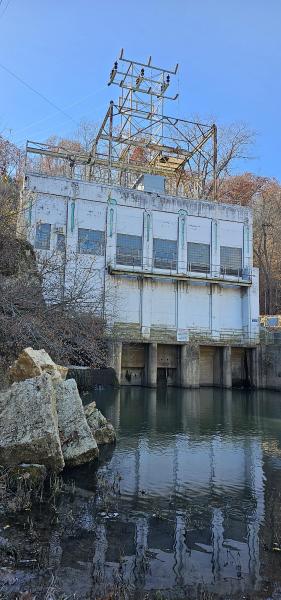
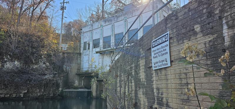
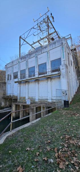
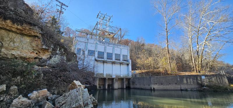
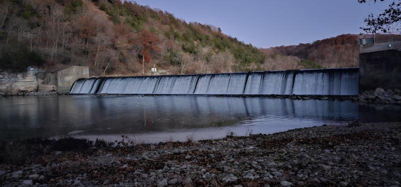
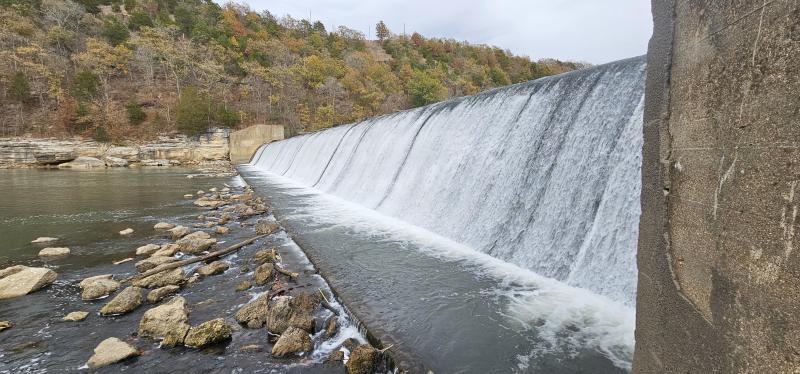
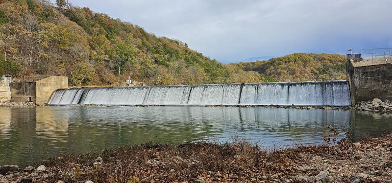
Here are some pictures of the dam and powerhouse. I like the art deco industrial architecture of the powerhouse.
-
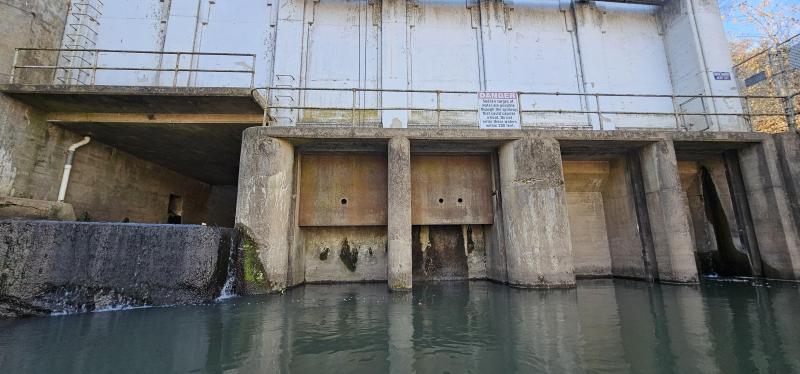
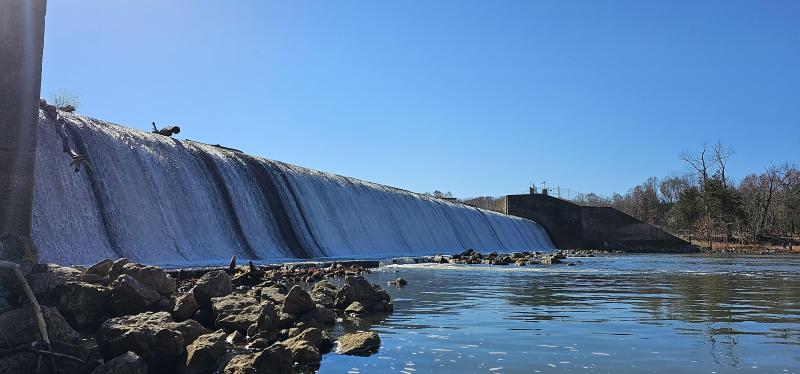
Yes, the gate is likely at the intake for the tunnel. I could see there was little water coming out at the powerhouse and that was likely leaking around the gate a bit. The dam is an ungated spillway which allows water to continually flow but the gate for the tunnel/powerhouse is at a lower elevation and can take all the water. Bagnell Dam has a gated spillway section to control the lake levels and the powerhouse is basically part of the dam which is more typical. The Lake was low. You couldn't even get into Onyx Cave and I hear that they are letting water out at the dam to meet power generation and water quotas downstream. From what I understand, no power will be generated at Lake Niangua/Tunnel Dam again. Conor
-
I think this is wrong. Note the mention of a "dry channel" at mile 66. https://missouricanoe.org/niangua-river/ We just floated this section and it is nice. There was no water coming out at the powerhouse and signs warn of unpredictable water flows when generating and to stay away. Signs say to move away if a horn blows because power generation is starting and a dangerous surge of water will follow. It also looks like there will be no more power generation here but the dam and lake will remain intact. https://ruralmissouri.org/tunnel-dam/ Conor
-
Interesting... I guess enough water flows over the spillway most of the time but I saw mention of it being a "dry channel" between the dam and powerhouse at certain times. Maybe only during seriously low flows which I would think might apply right now? Conor
-
I just found this. https://ruralmissouri.org/tunnel-dam/ Maybe they are no longer generating??? Conor
-
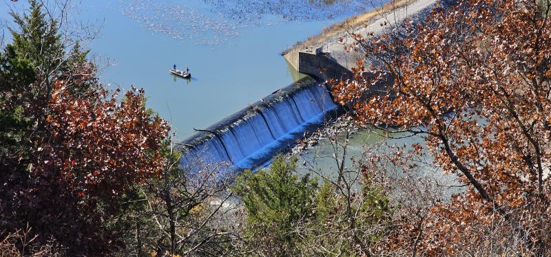
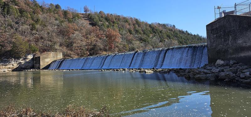
I did down to Lake Niangua/Tunnel Dam yesterday from Leadmine and really liked this section, even with several miles of slackwater paddling leading into and on to the lake. This whole area is super cool and I was wanting to do it from below the dam to Lake of the Ozarks/Ha Ha Tonka. I understand that is about 12-13 miles but that if they are generating power at the dam, the 6-7 miles below the dam will be too low to float since that section is being bypassed by the powerhouse. Water was spilling over the dam yesterday and the section below would have been easily floatable. I drove in this way and it looks like a super nice section of river that people likely don't float. This is a rugged and remote location for sure and you have to want to get there. Is there a standard power generating schedule or site that tells you when they will be generating or not? I understand little to no water will be spilling over the dam when they are generating. Conor

-
Also, we didn't fish but it looks like any part of this below Hutchins Creek would be good fishing with some nice holes and pools. For trash, it wasn't terrible but unfortunately most of what we saw were large trash items like tires and the white plastic wraps from round bales. These wraps are large and become a nightmare to remove with any water or sediment trapped in them. We picked up a few bottles, beer cans, airplane bottles, etc. but that type of trash wasn't terrible. It was just some of the bigger stuff and we didn't try to get that with this trip being a complete unknown. Conor
- 1 reply
-
- 4
-

-
Thanks. We were about to do this and decided to do something on the far upper Meramec above Short Bend instead. I posted that here under the Meramec. Either way, this one is on our list. Conor
-
We recently put in at the slab on CR 4280 which is 2 miles upstream from the confluence of Hutchins Creek and ended at Short Bend. A guy with a smart watch measured it at 13 miles or a tad more. We were dropped off at the slab as it didn't look like a good place to leave a car. The Cook Station gauge was at around 300cfs. The trip was scenic but nothing spectacular as many parts were rather pastoral, especially the first 7 miles or so.. Many minor springs pour in along the route which are pleasant. The first two miles was pretty low and scrapy. Parts are barely wide enough for a kayak. It is true creek at this point. At 2 miles in, Hutchins Creek tripled the flow or more and it became A LOT easier. I plan to scope slabs at CR 4270 and CR 4280 on that one which one looks like easy access off Hwy MM from the maps and maybe try that again next time as it looked more floatable at the confluence. Another slab at the end of Hwy W 4 miles into the trip must be portaged. This would make for a good access to avoid the upper slow parts with little water. Also, the scenery and sportiness of the river increase after getting 7 miles into the trip and just gets better until the end. You get many technical turns and such during the last 4-5 miles of this trip. Bluffs also increase in size and become more impressive. A steep sporty drop exists just before the Short Bend Bridge. You have time to react and decide to run or portage this bridge after the drop. The right bay was mostly open so I ran it without trouble. The others decided to portage. Hwy 19 and the public access come shortly after this. Overall it was a worthwhile trip but wouldn't be in a huge hurry to go back considering the logistics of being dropped off and such. I would definitely either try Hutchins Creek down or likely cut off the top and put in 4 miles down at the slab near Hwy W. You can get better scenery and similar or better sportiness from Short Bend to Wesco. Log jams were also pretty much a non-issue. There were snags to avoid but nothing crazy. The section below Short Bend has more logs all the way across than this part. I was concerned this section might be worse but it wasn't. Conor
- 1 reply
-
- 3
-
-
Nice. It sounds like this is going to be a good one and I plan to do it soon. How does it compare to slow sections of the Bourbeuse? The standing waves sound fun. Sometimes these slow rivers surprise you with really fast sections. The upper Bourbeuse is like that as well. Conor
-
I am interested in the 19 or so mile stretch from St. Francois to Washington State Park. I understand it has some long pools and that we will need to be going much of the time to make it in a day. Also, I was wondering about any obstructions to worry about? Are there any lead catchment structures like the Newberry Riffle below Desloge? I seem to recall hearing about some collapsed slab that might need to be portaged around as well somewhere. We plan to do this soon before the heat and sun turn this section into a slimy mess as described by Al Agnew. We did the stretch above earlier in the year and were pleasantly surprised it wasn't nasty and the scenery was pretty nice. We only had an "off" odor from Flat River to the lead containment structure which was a raging rapid in high water. Conor
-
Yep! Your description of this in lower water summer months told me I wanted to do it in the spring with less heat, sun, and higher flows and seems to have made it a much better float. I might have seen a few accumulations of greenish-yellow slime I usually don't see so guess I only got a mild preview of the summertime nasty. I would me most worried about lead in the fish. Are spotted bass not a concern? I figured eating anything out of this river would be a bad idea but I guess now. I think other low dams are being used for this. Someone told me that the dam at Rockford Beach had washed out a while back and that it was reconstructed to capture sediments but do not know if it is true. That is the last intact dam before the Meramec. Byrnes Mill is pretty much a fast riffle at this time and Morse Mill is washed out as well. Either way, based on what you say, I should probably plan on the part from St. Francois to Washington State Park sooner rather than later for water quality reasons. Conor
-
We did this not long ago on a warm day during a high water time. The river was at several thousand cfs on the Irondale gauge. We planned it this way as there is plenty of talk about this section getting pretty nasty when the water is low and the sun/heat are really out due to the sewage and lead tailings combining. Overall I was very pleasantly surprised by this section and thought it was well worth it. Disturbance from mining and some urbanization was obvious but not nearly as bad as some parts of the lower river. There was also not too much trash until the Flat River which appears to carry the bulk of the trash into this section of river. There was also an off smell, likely from the sewage, that started at the confluence and continued for a short bit. This seemed to stop after the Big River Lead Catchment Structure or whatever it is called which had turned into a Grand Canyon class whitewater rapid at this water level. Only one guy ran this. The rest of of portaged around it. Unfortunately the trash continued on down to the end and likely farther. The Big River is unfortunately known for trash. This section has nice bluffs and pleasant scenery. It definitely far exceeded my expectations but probably wouldn't attempt it in lower water when it is hot and sunny based on the description I read about this section at those times. The water was brown and muddy but not nearly as bad as most of the streams I drove across on the way there. I was worried about it being a death wish as well but the Big River was at thousands of cfs, not TENS of thousands of cfs like many I drove across that day. Conor
-
Access to and floating on Dry Fork of Upper Meramec???
Conor replied to Conor's topic in Meramec River
Well, the only thing better than the Dry Fork is the Little Dry Fork. We put in Sunday on the Little Dry Fork not far from Rolla. We were dropped off at the easternmost and most downstream crossing on County Road 3000 near where it runs into County Road 3220. The scenery is great from the start and you pass through scenic sandstone canyons on the way to the Dry Fork which has the same scenery on a grander scale, then proceeded to the take out at Boys Town. I have found several access points farther up. I feel that the western crossing of CR 3000 at the old WPA bridge would give you access to the remaining best scenery and topography based on the maps although one can tell it just gets more rugged as you drop farther through the watershed towards the Dry Fork. There are signs and houses here as well so would need to be dropped off. This is a higher bridge so hopefully could stay on road right of way. There are more numerous high water access points up in the city limits of Rolla and nearby. Some are in city parks near public walking trails that follow the tributaries of the Little Dry Fork. I have lived in Rolla for years and it is like a new connection has been made. These creeks drain much of the City of Rolla, especially the eastern and southern portions of the city. I drive over them daily and now look at them in a new way. I think the best high water access for something that isn't too crazy would be the Acorn Trail Parking at Deible Branch where it crosses Hwy O heading south out of Rolla. The other issue is adding miles. Both these trips were about 21 miles already so getting out before Boys Town is almost required. I think I could gain private property access near Hwy 8 which would cut off 3 miles at the bottom. There is also the possibility of getting picked up since this is near town and cell phone reception is good. You could call for a ride before you reach the end. Possibilities for this include the slab on CR 3000 near 3220 where we started or the CR 3410 "Pink Bridge" although that one is higher and the surrounding landscape is plastered with signs and purple. There was some trash in this stream but I would say it is overall very clean considering that this drains heavily populated areas with residential neighborhoods, businesses, and major roadways. You usually deal with lots and lots of trash in the river when you get near a city but this wasn't bad at all. I am used to seeing the Bourbeuse near Union and the Big River. The Big River is unfortunately a special case when it comes to trash. The entire thing has a decent amount but the lower 30 miles or so is the worst. I also found several Youtube videos of a guy kayaking these urban creeks through Rolla in flash flood conditions. Yes, there is real whitewater in the city limits of Rolla! Conor -
Access to and floating on Dry Fork of Upper Meramec???
Conor replied to Conor's topic in Meramec River
Anyway, I got to finally experience the Dry Fork in two parts. The first part was from Hwy F just SE of Rolla to Boys Town. We got dropped off and carried everything down below the bridge on Hwy F which was a bit of work. The launch was also pretty steep. This was 21 miles and a really nice float. The real scenery starts at the confluence with the Little Dry Fork but the part above this was nice as well. There was also a really nice little spring coming in on that upper part. This stream really reminds me a lot of the Bourbeuse but has its own personality. The geology is dominated by the Roubidoux Sandstone and the water clarity is on par with the Bourbeuse. The bluffs are sharper and more rugged than the Bourbeuse and I would say the gradient is definitely higher, with the exception of the part I recently did near Safe and High Gate. The Meramec Gauge at Cook Station was reading right at 1000 cfs when we put on so I am sure that helped with the flow! There are no gauges on this so you have to correlate with ones nearby. It was also mostly self-clearing of log jams which is a concern when you are committed to 21 miles! The Gasconade is definitely showing by the time you get down to around Hwy 8 or so. We saw the natural arch just upstream of Hwy 8 but missed the natural tunnel. The next part was from Boy's Town to Scotts Ford. There was about 2.5 miles on the Dry Fork and the rest on the Meramec. There is a nice pinnacle along the road at Boy's Town and supposedly a "Pinnacles Natural Arch" in the bluff although we couldn't find that. The bluff is very nice and attractive though. There are two nice bluff lines down to the Meramec and they are definitely in line with the sharper and more rugged bluffs you experience on the rest of this stream from the Little Dry Fork down. There is an MDC parking area at Boy's Town so you don't need to be dropped off. I think the next plan is to be dropped off at the Little Dry Fork on CR 3220 and take that down to Boys Town. That will cut off a few miles and allow us to experience new territory. This stream looks like a really nice tight little creek so it will need to be a high water float like the others. It also looks like the water is MUCH clearer than the main Dry Fork. The scenery from the CR 3220 slab is really nice and Roubidoux dominated. The CR 3000 crossing just east of Rolla might work but one would have to be dropped off there as well. This is an old WPA bridge with the ornate concrete railings but there are lots of signs on the surrounding properties. Another option to cut of more distance would be to get dropped off at the Pink Bridge on CR 3410. This isn't the best access though but could work if there wasn't enough water in the Little Dry Fork and you wanted to cut off the top part. Again, there are lots of signs on the surrounding properties. I do feel this would be a premiere float stream if it was floatable year round and the access was better. The scenery is great and this is a fun wilderness float. Conor Conor -
The far upper Big Piney from Simmons Ford to Dog's Bluff offers some spectacular scenery and is well worth the trip in the spring when the water levels are right. I would put this section up where with ANYTHING the upper Jacks Fork, Current, or Eleven Point has to offer in terms of scenery. The section is about 10.5-11 miles to easily done in a day and you will want to stop to admire the scenery on this one. This section is fast and sporty. It would eat the summertime drunks that pollute slower rivers alive. It also offers scenic sandstone bluffs and canyons, waterfalls issuing right from the bluffs as cascades and waterfalls, wild rock formations, and more. It definitely is among the top floats in MO without question. I understand one can go about 6 miles upstream to Gardner Ford although it is not as spectacular but worth doing. I might add this on to the top of this float sometime or end it early at the Tone Hogan Ford. One can also start at Tone Hogan Ford and add abuot 6 miles to the bottom by going down to Mineral Springs. This section is nice and scenic with ruins from the Lone Star Mill but slow. It is NOTHING like the fast sporty section just above. There is another tributary which I call the Little Piney of Texas County that comes in just upstream of Dog's Bluff. I have looked at a couple of the low water crossings on this one and it looks like it would have the same sandstone scenery I know on the corresponding Big Piney. Had anyone done this? I understand you want to blow through the Whites Ford/Flatrock crossing because the property owner is a jerk. Anyone done this one here? I am not talking about the Little Piney in Phelps County which is also a great stream. This one is about 4 miles from where I live and one of the best as well. I would suggest a gauge level minimum of 200cfs on the Jacks Fork at Mountain View Gauge as well as 900 cfs on the Big Piney at Big Piney gauge (Ross Access) in order to do this float. I have done it at 2000 cfs on the Big Piney Gauge and would probably try it up to 3000 cfs but boy would it be a sporting ride! Conor
-
- 3
-
-
I got private property access from someone about 5 miles upstream of Hwy B so just floated on through with no problems. The bridge would be a hard carry but could be done. I didn't see any no parking signs but parking is definitely not ideal at this bridge. It was rebuilt not too long ago and quite tall now with built up embankments and approaches. It looks like there is another access about 2 miles upstream from where I put in. The people who let me use their place put in here in tubes sometimes and float down to their property. Of course they are local so leaving cars there isn't a big deal. This is probably the farthest practical upstream access on the Bourbeuse. I don't see it being anything special for those 2 miles when compared to the scenery below Hwy B. https://www.google.com/maps/place/38°05'02.5"N+91°39'01.0"W/@38.084038,-91.650818,173m/data=!3m2!1e3!4b1!4m5!3m4!1s0x0:0x2beef5e9bfa32655!8m2!3d38.0840369!4d-91.6502708 Hwy 68 would be an extreme push to get it when there is enough water but not a flash flood. As with Hwy B, you would probably want to be dropped off here. Conor
-
It was just a nice float. I wonder if this has many fish as much of this part is just dry gravel with pools between in the summer. The scenery on the last 7 miles was really incredible and not what I was expecting. Conor


