chub minnow Posted May 21, 2010 Posted May 21, 2010 We have a group of guys (5-8) that are planning on floating Flat Creek from Mcdowell to Table Rock (James arm - hence the location of this topic). We were wondering if there were any really bad portages etc. along this stretch. We have scouted a lot of the river, but it's pretty remote out there and we have not seen a lot of it. The guys in our group are all experienced paddlers, so rapids and some technical sections are welcomed. We just don't want to drag boats through 2 miles of farm field - or worse - brambles. Getting information on this creek is next to impossible, so any help is appreciated. Also wondering if I should bring some trout flies for that upper section. we'll be C&R any bass or trout we might tie into, but no guarantees for any goggles or catfish that decide to eat my craw flies. Any fishing advice is welcomed, although I assume it fishes about like any other stream in the area. Information on good camp sites would be good to have as well. Thanks in advance!
Members ThatCopyGuy Posted June 25, 2010 Members Posted June 25, 2010 Did you float this? How long did it take? I floated Flat Creek from Jenkins down to EE last year and didn't have to drag the canoe once. Watch out though, if you haven't taken it, there was trees down under the water and all over the place. Our canoe got sunk twice in spots we couldn't avoid.
Paola Cat Posted June 25, 2010 Posted June 25, 2010 Did you float this? How long did it take? I floated Flat Creek from Jenkins down to EE last year and didn't have to drag the canoe once. Watch out though, if you haven't taken it, there was trees down under the water and all over the place. Our canoe got sunk twice in spots we couldn't avoid. That's some stellar SMB water. I've floated it many times .... In dead summer there's some draggin' but the fishing more than makes up for it. Cheers. PC
Members ThatCopyGuy Posted June 25, 2010 Members Posted June 25, 2010 Haha. I wouldn't know! We tried fishing for a bit, but then decided to tie everything down after the second sinkin! We had fun, though.
Wayne SW/MO Posted June 26, 2010 Posted June 26, 2010 These little streams are subject to the whims of high water, so its hard to get up to date info. Caution seems to be the key, that and the ability to read the current to avoid being pulled in to someplace you don't want to be. I haven't been on the creek in a couple of years, but I assume to log blocking it above EE is still there. Today's release is tomorrows gift to another fisherman.
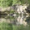
denjac Posted June 26, 2010 Posted June 26, 2010 Flat Creek, McDowell Low Water Bridge to Stubblefield Access (Winter Eagle Float) Usual Difficulty I-II (may vary with level) Length 7.5 Miles Avg. Gradient 6 fpm Dam Dam Photo of Third Passage by David Jackson taken 02/25/09 @ 4.5 ft. Gauge Information Name Range Difficulty Updated Level Flat Creek below Jenkins, MO usgs-07052820 150 - 1000 cfs I-II 00h32m 157 cfs (rc= 0.0 ) River Description FUN FACT: This is known as the "Winter Eagle Float" because it's renowned as a fine place for viewing eagles, especially in the winter (duh). Paddlers can see dozens of eagles perched on the bluffs along the river. The putin is at a low-water bridge with many large culvert tubes for good surfing. About a mile or so down from the putin lies the old flour millpond, a long, calm pool parallel to a steep rocky cliff and Farm Road 1165. At the end of the pool is the millpond dam. This dam remains mostly intact with three passages to exit. The "first passage" on the far left is most dangerous due to a hanging locust tree and a hairpin turn around the dam corner. The "second passage", about 10 ft. right from the first passage is floatable at higher water levels. When floatable, this passage is about 4 ft. wide and has a 2-3 ft. drop. NOTE: As of 2-25-09, the second passage has become obstructed with wood and debris. The "third passage" on the far right of the creek is your safest choice. This passage is a wide, broken section of the dam with a 2-3 ft. drop. About 200 ft. after the dam is "Canner's Ledge," which forms good creek-wide surf waves. After the ledge is a recently formed logjam (as of March 2009), passable at lower water levels through a slot to the far left corner of the creek. Approximately 500-600 ft. from the logjam will be another calm and deep pool, known as Eagle Alley. NOTE: Due to recent tornado activity in this area, many trees on the hillside to the river right and near the creek have fallen, none of which pose any obstruction to boaters. The Eagle Alley pool (approx. 1,000 ft. long) indicates you will be approaching another set of rapids. The first is a small surf wave that primes you for a creek-wide rapid called "Eagle Alley Ledge," which churns up some whitewater at all water levels (medium to high are best). Stick to the center of this rapid to avoid flipping. We've referred to this rapid as "final ledge" in conversation. NOTES: Most of all of the ledges on this section tend to smooth out more at high levels. After the final ledge (Eagle Alley Ledge), you will float under the FR 2080 iron bridge. This marks the beginning of some good surf waves and riffles that can be seen from the bridge. The flat rock bed underneath these rapids makes them smooth as butter. After these rapids and where the creek begins to bend lies Swallow Bluff, a great place to swim, fish, and picnic. I would approximate this as a halfway point on this run. Approximately another 1.5 miles will take you under the FR 1182 concrete bridge. From here you will float another approx. 1.7 miles you will arrive at the Stubblefield Rapids. The Stubblefield Rapids are the biggest stretch of whitewater on this run and ALL of Flat Creek. This fast set of rapids is very straightforward with no pin potential due to the smooth flat rock underlying. The entire stretch of this white water section is approximately 200ft. After these rapids is a large, deep, pool and the Stubblefield River Access Area (TAKE OUT). David Jackson See also this Google Map, with a few points of interest highlighted. StreamTeam Status: Not Verified Last Updated: 2009-05-04 22:50:58 Dennis Boothe Joplin Mo. For a nation to tax itself into prosperity is like a man standing in a bucket and trying to lift himself up by the handle." ~ Winston Churchill ~
KCRIVERRAT Posted June 27, 2010 Posted June 27, 2010 I've floated Flat Creek many times from the 39 bridge to EE. I've got buddies on this forum who don't care for the stretch but I have done well on it in the past. I have yet to float EE down to just above the lake, but plan to do so. Never have I had to portage around trees or such. Always a nice clean float. Plenty of smallmouth and goggleye. Check out the Missouri Gazzeteer for access points. HUMAN RELATIONS MANAGER @ OZARK FISHING EXPEDITIONS
chub minnow Posted August 27, 2010 Author Posted August 27, 2010 We did McDowell to Cape Fair with almost no dragging. Tree is still across the river and the portage was a pain, But other than that we had a great trip. Caught all species of bass We also caught crappie, catfish and I managed a nice Walleye right as we hit the lake. I'll post pics and more details later.
Wayne SW/MO Posted August 27, 2010 Posted August 27, 2010 Never have I had to portage around trees or such. There used to be a tree across the creek right above EE, I guess its gone now. Today's release is tomorrows gift to another fisherman.
ollie Posted August 27, 2010 Posted August 27, 2010 What? Rapids like that and I didn't know about it? Man I need to check that out at higher flows. "you can always beat the keeper, but you can never beat the post" There are only three things in life that are certain : death, taxes, and the wind blowing at Capps Creek!

Recommended Posts
Create an account or sign in to comment
You need to be a member in order to leave a comment
Create an account
Sign up for a new account in our community. It's easy!
Register a new accountSign in
Already have an account? Sign in here.
Sign In Now