


Sean P
-
Posts
8 -
Joined
-
Last visited
Recent Profile Visitors
862 profile views


Sean P's Achievements
Bleeding Shiner (1/89)
3
Reputation
-
 dpitt reacted to a post in a topic:
White River\North Fork Water Generation
dpitt reacted to a post in a topic:
White River\North Fork Water Generation
-
Thanks for for the explanation dpitt!
-
Thanks Dpitt! I did download this app but I'm assuming that in this app where it states "Units" that is the number of units currently running correct? If so that should help for sure. Thanks. that being said they can release water with out a generator running correct? If so that could be where my CFS come in to play correct?
-
Sean P reacted to a post in a topic:
White River\North Fork Water Generation
-
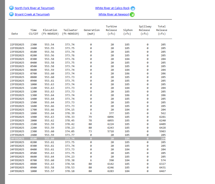
OK, I need some help! I feel stupid for having to ask but I was hoping to get a better understanding of reading the water generation for the White River and the North Fork. I will be down later in March and I usually Kayak and then wade certain sections while Kayaking if water generation allows. This trip though I wont have my kayaks, and I will be wading a few days before and after a two day guided trip on the white. So I was hoping to have a better understanding of the water generation schedule along with, if I know its up and moving to fast to wade I can move to another section of the river or say head to Crooked Creek (I will add if someone has another river that I can fish if water generation is up I would be up for the suggestion. Not asking for spots just public access to rivers that would be good for trout and Smallies. I know that the North Fork is easier to wade then the White. That being said I would like to have a better understanding of the water generation and how to read the schedule. I'm assuming the number that I want to look at is the "CFS"? If so, what is a good range to look at to determine if I will be able to wade safely both the white river and the North Fork. If its not the CFS that I need to look at what should I be looking at and is there a way to know about how many generators are actually running? Thanks!
-
 Sean P reacted to a post in a topic:
Best accesses for wade fishing?
Sean P reacted to a post in a topic:
Best accesses for wade fishing?
-
Sean P reacted to a article:
Lilley's fishing report, 2/8
-
oodlesiggy, why should I stay away from Smithville Lake? I know they have walleye in that lake also, are they hitting there?
-
trythisonemv reacted to a post in a topic:
Walleye at the truman dam
-
Thanks guys! I'm not looking for spots just if the bite had started yet.
-
Sean P reacted to a post in a topic:
Walleye at the truman dam
-
Has anyone had any luck with getting walleye at the dam?
-
 Sean P changed their profile photo
 -
I made it down and the fishing was great. Also fished the river and caught a few smallies. Cant wait for trout season. For now busy tying flies to replenish my supple.
-
Fishingmill reacted to a post in a topic:
New PB Rainbow
-
Nice fish! Congrats!

