
Phil Lilley
-
Posts
19,030 -
Joined
-
Last visited
-
Days Won
132
Content Type
Profiles
Forums
Blogs
Events
Articles
Video Feed
Gallery
Everything posted by Phil Lilley
-
Posted your report over on the Pages section under Jack's River Reports. Sounds like you had wonderful time. The boys will always remember these trips!
-

No generation on Taney this morning
Phil Lilley replied to Phil Lilley's topic in Upper Lake Taneycomo
Tomorrow - water off all morning, on at noon. <1 unit at 1, 1 at 2 pm. Then almost 3 units at 3. It's not impossible with 3 but not the best. Friday morning is your best bet unless you can get there before 3 pm. -
Looks like the generation pattern has finally changed to match the cooler weather we're enjoying. No generation over night, less than one unit running starting at 8 or 9, then heavy this afternoon.
-
 White River and Norfork Tailwater Dry Fly Fishing: Is this top-water bite as good as it gets? Author Unknown ~ The answer to the title question is highly subjective, and if you asked nine different anglers their thoughts, you would get nine different answers regarding favorite spots around the country for surface action. The allure of the White River and Norfork Tailwater is how easy it is to find absolutely perfect dry fly water when the flows are low. There are plenty of areas where a well-presented dry fly will catch fish most of the day throughout the year, but spring is the season where bigger bugs can make for easier and ultra-productive dry fly fishing. The most frustrating aspect of approaching these rivers from a dry fly perspective is that the most effective flies are going to have to be very small to consistently produce rises during the fall, winter and very early spring. Stalking wary trout with microscopic midges is not for everyone, but it is a great way to see just how good you are. Mid-spring through early summer is the time of year when White River guides and regulars can put away their tiny midges for awhile and focus on throwing bigger flies. Of course, low water and the hatches that accompany minimum flows are dictated by Bull Shoals (White River) and Norfork (Norfork Tailwater) Dams. Almost all of the best dry fly fishing occurs when the rivers are dead low, so be sure to take advantage of those uncommon years where dry weather patterns and spring coincide. It can be pure magic, as full days can be spent matching the hatch and coaxing rises in a setting that is comfortable and splendidly unique. Nymphs will usually catch the most fish, even during a good hatch, but there are times when only a dry fly will produce the desired results. How effectively an angler reads and approaches the skinny water of the White and Norfork is going to play a major role in whether they fail miserably or have the time of their life with their dry fly pursuits. Fly selection is also important, but Ozark trout are not quite as "snobby" as their counterparts found on other famous shallow-water fisheries like the Henry's Fork in far eastern Idaho. This is because hatches do not occur often enough for the fish to get overly selective, and the majority of anglers predominantly fish with weighted flies under a strike-indicator. Still, do not expect to find totally receptive quarry, as your dry fly must compete with natural insects on the surface during a hatch while also contending with trout that have access to all the nymphs they could care to eat near the bottom. That said, there are magical times when favorable conditions, perfect weather and decent hatches combine to offer up once-in-a-lifetime dry fly fishing. What makes it so special is that the river's big fish become very susceptible to surface presentations, and the setting is like nothing else - this water could not be more perfect for dry fly fishing when the dams are shut down. Matching the season In a perfect world, fish would rise to large caddis and mayflies all year long, but unfortunately, that type of activity is usually only witnessed in the spring if the water is low. Typical spring weather patterns severely limit wading opportunities on the White River and Norfork Tailwater because lake and river levels will often be high this time of year. Keep your eye on generation patterns and reservoir levels - the Blue Ribbon Fly Shop Web site also lets anglers know if prime dry fly fishing is a possibility at any given time. If low water becomes common during the day on either river from late March through early June, jump on the chance to get in on some great top-water fishing. The best dry fly action will usually start in the middle of April on the White, with the Norfork usually running a week or two behind. Low water in May is what dry fly dreams are made of and the hatches tend to peak sometime around Memorial Day. Summer can seem like a letdown from a dry fly perspective, but in reality, this season is a great time to hook into a large fish on the surface. Hatches are lighter than they were in the spring, so summer trout can become very opportunistic when it comes to taking advantage of a light insect emergence. The downside to the summer season is that low water is highly unlikely to be found after mid-afternoon, and forget about an idyllic evening spent analyzing the hatch and casting to rising trout; by dusk, both rivers will be high and fast. Anglers and fish alike must make the most of their efforts during the summer. Fall and winter offer up some great dry fly fishing and plenty of wading, but small midge and caddis patterns fished on 6x or 7x tippet will often be necessary to fool the fish. Large terrestrials can work very well in early fall, but that action drops off quickly through October. Spring is hands down the best time of year to fish dries on the White and Norfork, and a trip diligently planned with the help of a local expert can result in the dry fly fishing experience that dreams are made of. Matching the Spots Because the water found within a couple of miles of the dams is very cold, hatch activity is somewhat limited in the upper reaches. For the best chance at finding active surface feeders, fish below Wildcat Shoals on the White and the Long Hole on the Norfork. There can be decent action closer to the dams, but the bugs will almost always be smaller than what is found just a few miles downstream. On the Norfork, the best water for dries will be shallow riffles and flat runs along rock or rip-rap banks. In general, the deep and slow water of the Norfork are home to trout that are too lazy to steadily rise to the top for a beefy bug, but these same trout will eagerly eat a tiny midge emerger right below the surface. It pays to stick to moving water when dry fly fishing the Norfork. The same types of water that fish well with dries on the Norfork will also produce over on the White, but slow, deep pools can also be good spots on that river. Who knows why there is such a difference between what constitutes a good spot on these two sibling fisheries, but the fish are the ones in charge of telling us where and how to fish. The slow and deep waters of the White are the most productive if the wind is blowing upstream and there is chop on the surface. Look for areas where the bottom is dark and not overly deep - it also helps to fish near structure like submerged boulders and exposed root wads. Matching the hatch Over the years, the hatches on the White River and Norfork Tailwater have become more abundant and diverse. Now, the annual caddis hatch during the spring (water flows permitting) is an area draw unto itself. Caddis are not the only insects on the water; sulphur mayflies add some variety most days. Crane flies can also be found in decent numbers on the Norfork and there are a few showing up here and there on the White. Midge hatches will often coincide with the emergence bigger bugs, so it never hurts to carry some small midge dries for when the bite gets tough on caddis and mayflies. Fly selection is relatively simple when matching White River and Norfork hatches, and this simplicity makes this particular dry fly opportunity appealing to beginners and intermediate fly anglers. There have been many times where trout will literally eat anything floating - including white, fluorescent green or orange Palsa strike-indicators. If your indicator is getting more attention than your nymph, it is definitely a signal to switch to a dry. For matching the caddis hatches, standard elk hair patterns in #14 and #16 will suffice, but it never hurts to mix things up with respect to conventional sizes and colors. Basic grays and olives will work throughout the spring, and there is a micro-caddis hatch in the fall on both rivers that can be cinnamon in color. Make frequent casts, short drifts and never be afraid to add a little extra movement to the fly by delicately raising your rod tip. These fish are suckers for a skittering caddis pattern. Sulphur mayflies, which resemble PMD's, can actually be the dominant spring insect hatch on the White and Norfork, but it all depends on the individual year. Basic Cahill or parachute-style dries in #14 and #16 will work - for those who do not know; adult sulphurs are yellow to yellowish-orange in color. When fish are keying in on this hatch, the rises will resemble a toilet bowl flushing and every trout will look huge. Long dead drifts will produce better results than imparting movement to the fly like with a caddis. Because the little crane flies of the Norfork are similar in color and size to the sulphurs, if you find yourself in the midst of this particular emergence, then it does work to fish a sulphur pattern with some action. Sulphur and crane fly activity is pretty much limited to the spring and early summer, but caddis have a much longer presence. The best way to take advantage of the White River and Norfork Tailwater dry fly experience is to utilize a drift boat to get to difficult to access stretches of water, but there are plenty of good walk-in areas where excellent fishing opportunities are available. If you plan on fishing early in the morning before the hatches are really coming off, try nymphs that imitate both caddis and sulphurs. For caddis, soft hackles along with many other popular patterns will do the trick. A big mistake many new anglers make is that they assume that sulphur nymphs are yellow. This is not the case - sulphur nymphs are dark brown, so weighted pheasant-tails are always a good choice. Langdon's misson during our three day guide trip excursion was to land a 20" brown. Check! Photo taken March 15th, 2010. Getting to the right place at the right time to experience the incredible dry fly fishing available on the White River and Norfork Tailwater will take some luck and effort. Because perfect conditions do not occur every spring, many anglers will forget about the rewards and will get their dry fly fix on more predictable rivers. This means that fly fishermen who understand all of the variables on the White and Norfork can often have insane dry fly fishing all to themselves. Be prepared for anything on a trip to these rivers, and do not plan on having a solid dry fly bite all day long. This year (2010) is looking like everything may come together for optimal dry fly conditions to develop, but we will not know anything regarding this situation until the first of April at the earliest. It has been several years since there has been a steady and long dry fly fishing window during the spring on the White and Norfork. Hopefully, this will be the spring when we can trade outboards and indicators for dry fly dressing and upward-looking trophy trout.
 -
Good Morning. You have, and you're going to continue to see, posts made by me the next few days (weeks) as I build content on the "Pages" side of this forum site. As I've explained before, Ozarkanglers has 2 separate parts - a Wordpress driven site (http://ozarkanglers.com) and the forum (http://forums.ozarkanglers.com). Within the forum, Invision has developed an application for adding content like a regular website, along with the forum, chat, gallery and more. My goal is to eventually move everything viable from OA to FOA so that everything is in one place and connect better. Up to this last update, I had to copy/paste articles and reports from FOA to OA which is time consuming. Now I can "promote an article" to Pages with a couple of clicks, BUT when I do it duplicates the post and adds it to the feeds page (Unread Content). That's annoying to me and I'm sure others. I've had one person so far ask why his post was reposted in which I explained and he was ok with it. What this does is adds fishing reports to the lake or river's page under that category where someone can go and fine reports for that lake or river without wading through all the posts on the forum, like an archive. The Pages, like Table Rock's page, will show a lot of information about that lake. I'm hoping to develop these pages for all the lakes and rivers covered on OA, adding good, current information for anglers and outdoor lovers alike. I started OA back in the mid 90's for posting fishing reports for Lake Taneycomo... never thought it would get this big! But it's fun... especially meeting and getting to know so many wonderful people over the years. That's the best part about it. I'm very grateful for @Al Agnew and many others that have contributed so much to the content of this site. I'm always open to ideas... just have to be patient with the progress. I don't have a lot of time to dedicate to it, especially in the summer. It's a good winter-time project.
- 1 reply
-
- 1
-

-
 Water levels are running at 372cfs and water clarity has been clear. The river is looking great and the trout have been on the bite. Y2k’s are the hot fly this last week. Really hitting it hard. And olive woollies and hopper dropper rigs have been fun to fish on some days. Not many hitting the hopper but that occasional trout coming up to hit the hopper is priceless. Got to have the dropper below the hopper. It is where you will get the most hits. I like a small nymph or small Y2k. Hot pink and white trout magnets have been hot this week. And to be honest hot pink trout magnets always catch trout. Fish just off the bottom below a trout magnet float. And works great on a fly rod for smallmouth on local creeks like the Myatt and South Fork. These smaller creeks that run into the Spring River are hot spots for catching smallmouth. Nice weather this week, get out and enjoy. Tight lines and good luck, Mark Crawford
 -
Fished today by myself for about 5 hrs Had 12 keepers and 21 shorts. Caught the first 6 fish jig and crawler fishing then switched to bottom bouncer and spinner harnesses in 16 to 20 ft deep. Gold and green where the colors today. Biggest fish 19 inches. He was part of a double the other was 16 12 inches. Together with what the wife and I caught yesterday. Had 21 keepers and 28 shorts. Only kept one fish all they others r still there. Spent the first part of yesterday fishing flats. Without much success. Then hit points in the lower end of the lake and that was much more productive. View full article
-
 Special State Bass Management Areas Mainstream and its tributaries, except as noted below: Daily limit: Black bass—12 fish including no more than 6 largemouth bass and smallmouth bass, combined total of both species. Size limit: Spotted bass—None From Leadwood Access to the Meramec River: Daily limit: 12 black bass including no more than 6 largemouth bass and smallmouth bass, combined total of both species, may include only 1 smallmouth bass Size limit: Smallmouth bass—minimum 15 inches
 -
 Two Rivers Canoeing Adventures Akers Ferry Canoe Rental Cave Spring Park and Current River Cavern Circle B Campground Dogwood Cottages Harvey's Alley Spring Canoe Rental KC's on the Current Riverside Motel, Cabins & Beulah's Country Home Shady Lane Cabins & Motel The Landing Troutt & Sons, Inc. Windy's Canoe Rental Big Spring Lodge and Cabins Golden Hills Trail Rides and Resort Van Buren Chamber of Commerce Camelot RV and Campground Jadwin Canoe Rental Running River Canoe Rental
 -
 **Bass, black (largemouth), smallmouth and spotted bass (kentuckies)- 12-inches length limit, 6 daily, 12 possession. Exceptions: the Jacks Fork River from the Highway 17 bridge to the Highway 106 bridge -- Only One (1) smallmouth bass over 18-inches. Statewide season on bass in rivers and streams is open from the 4th Saturday of May till the last day in February annually. White bass, striper, hybrid bass- 15 total daily (only 4- 18 inches or longer can be kept in a daily limit), 30 possession. Rock bass (goggleye) - no length limit, 15 daily, 30 possession. Crappie, white or black - no length limit, 30 daily, 60 possession. Bluegill - no limit Catfish - no length limit, 10 daily (only 5 can be flatheads in a daily limit), 20 possession. Walleye - 18 inch minimum length, 4 daily, 8 possession. From Cedar Grove to Arkansas state line - daily limit on hogsuckers is 5. Fishing Licenses - Residents - those fishing of the ages of 16 and older and 65 are required to have on their person a valid Missouri fishing license. Those 65 and older do not need a fishing license. Proof of residency - Valid Missouri Drivers License. Non-residents - those fishing of the ages of 16 and older are required to have on their person a valid Missouri fishing license. A Missouri TROUT STAMP is required for ANYONE who fishes the trophy or Blue Ribbon area on the Current River, regardless if the angler is keeping or releasing their catch. (New March 1, 2005) Costs - Resident - $12 annual Non-resident - $42 Daily - $7 Trout Stamp - $7 Buy Missouri Fishing Licenses Online! Report Violations - Poachers In cooperation with the Missouri Department of Conservation, Operation Game Theft works to stop the illegal taking of fish and wildlife that includes trophy animals and rare and endangered species. Missouri Wildlife Code
 -
 Jack's Fork near Mountain View, Missouri Jack's Fork at Alley Spring, Missouri Jack's Fork at Eminence, Missouri
 -
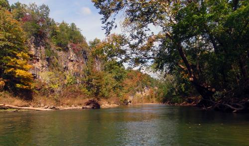
 Mark, a member on OzarkAnglers forum, ask a question about help on floating and fishing the Jack's Fork River. One thing nice about OA's forum, there's quite a few members who's knowledge of Missouri's rivers is extensive and their willingness to give advice is second to none on the world wide web. The following is a compilation of postings by various people answering questions about the Jack's Fork. Mark's questions: He and his buddy are planning on floating the second week in June. Their put-in point is Prongs or Buck Hollow. They expect to float between 5 to 10 miles a day and pull out somewhere between Bay Creek and Eminence. Mark is hauling down a squared off Stern canoe and thinking about taking a 2.5 hp motor to get them through the slow stretches of the river. River levels are important when floating any stream. USGS provides measuring stations at various points in Missouri's rivers and there are 3 on the Jack's Fork. The Prongs stretch of the river can be marginal later in the summer for floating because the river becomes too low and Mark's next question is about which measuring station should he read and at what level should he not put in at Prongs because of low levels. Gavin - The river really flattens out below Rymers and the main obstacles are submerged rocks, sweepers, and there are a few sporty little ledges to run. Best scenery is between Prongs & Rymers. I'd want at least 150 cfs if you want to head down from the Prongs in a loaded boat. Prongs or Buck down to Alley would be a nice trip for 3 nights on the river. Bring a good saw because firewood can be scarce. Moreover, the shuttles are LONG...you might want to hire that out to maximize your time on the river. I'd use Harvey's @ Alley Springs and park your vehicles in their lot. Watch for flash floods, forecast. Steve - Four or five days = 3 or 4 nights? Three nights is perfect for me from Buck Hollow to Alley assuming the river is floatable. My reference point on the gauge is feet instead of cfs. My preference is 1.5 to 2.0 feet. Below 1.5 & you will start dragging quite a bit. The gauge gets to three feet & the river is moving along a somewhat better clip. Much less time will be needed on the river. I think it is closed at 4 feet. My wife and I do Buck to Alley every year in three nights, and and we paddle basically not at all & fish it pretty hard. About the only "must see" location on the river to me is Jam-up cave. Really a spectacular entrance. Also the mill at Alley Springs. Flash floods- always camp high above the water and have a way to escape rising water if there is rain in the forecast or if it's raining. River levels can rise as much as 10 feet in some areas. ColdWaterFshr - I think you could get away with as less as 100 cfs on that gauge, but you would have some dragging to do. If it were me, I would put in at Prongs or Buck and take out at Alley Spring. Leave your cars at Alley because they'll be safer there due to the Park Ranger and campground host that patrols the area. Only time I felt it was slightly tricky was from the Prongs and that was in high water -- the gradient is a little steeper up there and its a little more twisty. I remember once when we floated that 7 or so miles from Prongs to Hwy 17 in a little over an hour and it had some fun little rolling waves, but still very mild class I-II. From Buck (Hwy 17) on down to about Bay Creek its not as fast, and after Bay Creek its slows even more. Blue Spring and Ebb and Flow Spring are also cool to check out, but the bluffs are what you'll spend your time viewing. Freeze milk jugs full of water for ice. Always keep a damp cloth over the ice chest lids, this will help keep the ice. Al Agnew - The Mountain View gauge is the best one to use, but the Alley Spring gauge is located above the spring, and much of the time there isn't much difference between the two gauges. With a square stern canoe loaded with camping gear and two guys who don't want to work too hard, I'd want at least 120 cfs on the Mountain View gauge to float from the Prongs. But also keep in mind that the upper river from the Prongs to Rhymers has some steep little rapids and rock gardens, along with some serious sweepers here and there (sweepers are trees that lean over the river or into the river on the outside of fast water bends, too low to go under, and the current "sweeps" you into them, "sweeping" you out of the canoe or the canoe under the tree). Unless you are really good at maneuvering that square stern in fast water, you for sure don't want TOO much water. I wouldn't attempt it from the Prongs if the gauge reading is much over 300 cfs unless you're sure you know what you're doing in that canoe full of gear. I know you float the Eleven Point a lot, but the Eleven Point is much wider and more open in all the riffles than the upper Jacks Fork. The Buck Hollow and the Alley Spring gauges are about equally valid for the Jacks Fork above Alley Spring. The Alley gauge is above the spring, and its flow readings are usually pretty similar to the Buck Hollow gauge (note I'm talking flow in cfs, not level in feet) unless there's a flash flood that has reached Buck Hollow but not Alley yet. If I'm floating from Rymers to Alley I'll use the Alley gauge, if floating Prongs to Rymers the Buck Hollow gauge. I'll say it again, if you are already familiar with a stream and know what the level in feet signifies for that stream, that's great, but the flow in cfs is a much more useful reading if you aren't familiar with the stream. If you tell me the Jacks Fork is at 2 feet on the gauge and I don't know the Jacks Fork and have never paid attention to that particular gauge, I have zero idea what you're talking about. But if you tell me the Jacks Fork is flowing 200 cfs at that gauge, I KNOW what 200 cfs looks like on ANY Ozark stream, and know that on any stream comparable in size to the Jacks Fork, 200 cfs is very floatable but not high. From the Prongs to Buck Hollow, the river is all short rocky pools and fast, steep riffles full of rocks. The pools start to get a little bigger below Buck Hollow, the riffles are a little wider, but it's still a lot of fast water to Rhymers. From Rhymers to Bay Creek you start encountering a lot more shallow, gravelly pools and runs, but with enough deep water and rocky riffles to keep things interesting. From Bay Creek to Alley the runs get longer and shallower, the pools farther between, and the riffles often wide and very shallow. From Alley to Eminence, due to the influx of Alley Spring, the river is much bigger and easier to run, but the fishing suffers. In the upper end the bluffs are numerous but not very big. The farther downstream you go, until you reach Alley Spring, the bigger the bluffs get. Below Alley the valley widens considerably and the bluffs get less tall. But the upper river is almost a canyon, with no bottomland, just a hill on one side and a bluff on the other all the way. Which is why it comes up so quickly after heavy rain and gets so high. It truly is the most dangerous river in MO when there is heavy rain in the watershed. Jam-up Cave is the only "must-see", although I would argue that the whole river from the Prongs to Alley is a "must-see". If you wanted to, you could spend a day poking around Jam-up Cave, because it's a part of a very interesting geological system. The cave comes out onto the river valley in a big bluff. Jam-up Creek is a small stream that flows off the highlands toward the river to a point just a hundred yards or so in back of that bluff, and then the valley of Jam-up Creek swings away from the river and winds through the hills for another couple of miles before reaching the river valley. But the creek drops through a hole in its bed (which is sometimes jammed up with driftwood, hence one origin of the name) right where its valley comes closest to the Jacks Fork, to emerge at Jam-up Cave. Not only that, but there is another hole in the roof of the cave between where the creek enters it and where it empties into the river, which gives you a "skylight" into the cave. The creek within the cave drops over a waterfall a little ways back into the cave, and that skylight, at the right time and the right sunny days, shines a sunbeam right onto the waterfall. it's a truly magical place. So you could hike around the bluff and atop it, and look for the holes from above, as well as clambering around within the cave.
 -
Just got word - the gates at Powersite Dam that were stuck in the down position are now fixed. So we should see normal levels on Taney (higher levels) now. You'd have to spend a lot of time on the upper lake to notice the difference... but the biggest change will be the depth of the lake during very little generation or no generation. By the way, it has been mentioned that they may try to get more cars out Thursday morning. That means no generation. It has not been confirmed.
- 1 reply
-
- 4
-

-
 Meramec River at Steelville Meramec River at Cook Station Meramec River at Sullivan, MO Meramec River at Valley Park, MO Mermaec River at Eureka, MO
 -
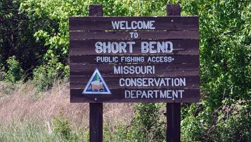 Missouri Department of Conservation Public Accesses Area Name Acres of Public Land Frontage Miles Allenton Access 7.88 0.50 Blue Spring Creek Access Campbell Bridge Access 10.0 Catawissa Access Chouteau Claim Access 15.11 0.50 Flamm City Access 20.44 0.50 Highway 8 Access Redhorse Access 47.33 0.25 Riverview Access 15.15 0.10 Sand Ford Access 32.65 0.25 Sappington Bridge Access 10.0 Scotts Ford Access 17.81 0.30 Scotia Bridge Access Short Bend Access 74.63 Times Beach Access 0.96 0.25 Valley Park Access 5.00
 -
 Special Management Rules for Meramec River Main steam and its tributaries, except as noted below: ◾ Black bass—Daily and possession limit is 12 fish and may include no more than 6 largemouth bass and smallmouth bass, combined total of both species . ◾ Spotted bass—No minimum length limit In Crawford and Phelps counties. ◾ The use of porous-soled waders is prohibited . ◾ Only flies and artificial lures may be used, and soft plastic baits and natural and scented baits are prohibited when fishing for any species. From Scotts Ford to the railroad crossing at Bird’s Nest. ◾ Smallmouth bass—15" minimum length limit . Daily and possession limit of 12 black bass, which may include no more than 6 largemouth bass and smallmouth bass, combined total of both species, may include only 1 smallmouth bass. From Highway 19 bridge in Dent County to Pacific Palisades Conservation Area. ◾ Goggle-eye—8" minimum length limit Red Ribbon Trout Area: From Highway 8 bridge to Scott’s Ford and in Dry Fork Creek from the elevated cable crossing to its confluence with the Meramec River—8 .2 miles. Two (2) trout daily limit and must be at least 15 inches in length to keep, using only artificial lures and flies only. Bass, black (largemouth), smallmouth and spotted bass (kentuckies)- 12-inches length limit, 6 daily, 12 possession. Statewide season on bass in rivers and streams is open from the 4th Saturday of May till the last day in February annually. White bass, striper, hybrid bass- 15 total daily (only 4- 18 inches or longer can be kept in a daily limit), 30 possession. Rock bass (goggleye) - no length limit, 15 daily, 30 possession. Crappie, white or black - no length limit, 30 daily, 60 possession. Bluegill - no limit Catfish - no length limit, 10 daily (only 5 can be flatheads in a daily limit), 20 possession. Walleye - 18 inch minimum length, 4 daily, 8 possession. From Cedar Grove to Arkansas state line - daily limit on hogsuckers is 5. Fishing Licenses - Residents - those fishing of the ages of 16 and older and 65 are required to have on their person a valid Missouri fishing license. Those 65 and older do not need a fishing license. Proof of residency - Valid Missouri Drivers License. Non-residents - those fishing of the ages of 16 and older are required to have on their person a valid Missouri fishing license. A Missouri TROUT STAMP is required for ANYONE who fishes the trophy or Blue Ribbon area on the Current River, regardless if the angler is keeping or releasing their catch. (New March 1, 2005) Costs - Resident - $12 annual Non-resident - $42 Daily - $7 Trout Stamp - $7 Buy Missouri Fishing Licenses Online! Report Violations - Poachers In cooperation with the Missouri Department of Conservation, Operation Game Theft works to stop the illegal taking of fish and wildlife that includes trophy animals and rare and endangered species. Missouri Wildlife Code
 -
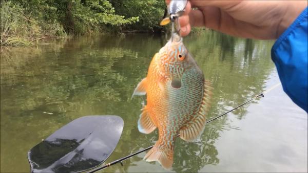
 Huzzah and Courtois are sister streams, indeed almost twin sisters. They both begin in rugged country along Hwy. 32, which divides their waters from the headwaters of Black River, they flow parallel to one another toward the Meramec, and they finally merge just a mile or so before emptying into the larger river. Along the way, they are similar in size and character, with exceptionally clear water, wide gravelly beds, and narrow valleys rimmed by high wooded hills. They are as pretty as you'll find in the Missouri Ozarks. They are also as popular as you will find anywhere in the Ozarks. Large campgrounds and canoe rentals are located on both streams, but the total amount of easily floatable water is less than 15 miles on each, so those lower miles are almost always crowded during warm weather, even on weekdays. The do-it-yourself floater who is willing to work at it can avoid some of the crowds by going farther up on the Huzzah and Courtois, or by putting in very early in the morning. Or one can just put up with the crowds of river dorks and still catch some fish. The smallmouth is king in these two streams. Largemouth are fairly uncommon, and although one can occasionally catch a spotted bass or two in the lower reaches, the spots don't seem to like the cool, clear, fast waters of these two streams. Goggle-eye are abundant along with the other sunfish species, and suckers are thick. Huzzah Creek Level near Steelville, Missouri
 -
 **Bass, black (largemouth), smallmouth and spotted bass (kentuckies)- 12-inches length limit, 6 daily, 12 possession. Exceptions: On the Meramec, Big, and Bourbeuse rivers and their tributaries, the daily and pos- session limit for black bass is twelve (12) in the aggregate and may include no more than six (6) largemouth bass and smallmouth bass in the aggregate, except that the daily limit may include no more than one (1) small- mouth bass on the Big River from Leadwood Access to its confluence with the Meramec River, the Meramec River from Scotts Ford to the railroad crossing at Bird’s Nest, and Mineral Fork from the Highway F bridge (Washington County) to its confluence with the Big River. Statewide season on bass in rivers and streams is open from the 4th Saturday of May till the last day in February annually. White bass, striper, hybrid bass- 15 total daily (only 4- 18 inches or longer can be kept in a daily limit), 30 possession. Rock bass (goggleye) - no length limit, 15 daily, 30 possession. Crappie, white or black - no length limit, 30 daily, 60 possession. Bluegill - no limit Catfish - no length limit, 10 daily (only 5 can be flatheads in a daily limit), 20 possession. Walleye - 18 inch minimum length, 4 daily, 8 possession. From Cedar Grove to Arkansas state line - daily limit on hogsuckers is 5. Fishing Licenses - Residents - those fishing of the ages of 16 and older and 65 are required to have on their person a valid Missouri fishing license. Those 65 and older do not need a fishing license. Proof of residency - Valid Missouri Drivers License. Non-residents - those fishing of the ages of 16 and older are required to have on their person a valid Missouri fishing license. A Missouri TROUT STAMP is required for ANYONE who fishes the trophy or Blue Ribbon area on the Current River, regardless if the angler is keeping or releasing their catch. (New March 1, 2005) Costs - Resident - $12 annual Non-resident - $42 Daily - $7 Trout Stamp - $7 Buy Missouri Fishing Licenses Online! Report Violations - Poachers In cooperation with the Missouri Department of Conservation, Operation Game Theft works to stop the illegal taking of fish and wildlife that includes trophy animals and rare and endangered species. Missouri Wildlife Code
 -
 Huzzah Creek USGS river gauge: Huzzah Creek Near Steelville, located at the Hwy. 8 bridge, just downstream from Dry Creek. This gauge is very reliable for the creek downstream, but with low water levels, Dry Creek adds enough water to make a noticeable difference between the stretch above and the one below. Low flow information, as well as highest flow that is likely to be fishable, may not be as accurate as it is on some gauges, because the Huzzah gauge has only been online for a couple of years. Normal flow for December through February: 100-250 cfs. Normal flow for March through May: 200-400 cfs. Normal flow for June through November: 70-120 cfs. Low flows range from 30-60 cfs. Highest flows likely to be fishable range from 500-700 cfs. Huzzah Creek Level near Steelville, Missouri Courtois Creek USGS river gauge: There is no gauge on the Courtois. However, the proximity of the Courtois and Huzzah makes the Huzzah gauge fairly useful for the Courtois as well; the two streams are not only similar in volume but they usually receive similar amounts of precipitation. Once in a while a localized storm will cause one to rise while the other does not, so one cannot depend entirely on the Huzzah gauge. See Huzzah gauge information for normal, low and high flows, and navigability.
 -
One of those days where I couldn't really nail anything down, fished different kinds of structure using several techniques and baits. Caught one here and there and ended up with a dozen bass, biggest went about 2.5 lbs. The rest were 12-14" spots and LM's. Got the most on a Trick Worm fished on a Spider head. Got a couple of a c-rig, a couple early on a wobblehead with a Megabug, and one or two drop shot fish. A couple of brush piles that were in the 10-20 foot range held a few, a few out on gravel, and the early fish were back in a main lake pocket. There was some scattered TW activity, I was able to throw a Nutech Zinc spoon a few times on TW fish, had a couple of bites, got one about halfway to the boat that jumped a good three feet out of the water and tossed the spoon. I could be wrong, but I am thinking we may see some main channel, summer early morning, TW activity soon, I think they are just getting started. Lots of shad out in the channel for them to eat. Surface temp as close to 90 as it can get, I saw it hit 89.9 at one point. When I got to the ramp there was a husband/wife team (assuming they are married) launching. Husband in the boat, wife backing the trailer in. Husband yelling instructions: BACK! BACK! TURN! TURN! NO, TURN THE OTHER WAY! I SAID THE OTHER WAY! PULL UP! PULL UP! OK, NOW BACK! BACK! They got it done, you have to learn sometime right? View full article
-
Generation has been consistent the past few weeks. Dam officials have run "fish water" from about midnight until noon each day and then up to three or four units until late at night. With temperatures in the mid 90's, Table Rock's turbines are turning out much needed electricity.I call "fish water" the generation to the tune of 20 megawatts, or less than one unit. The top of the spillway at Powersite Dam is still damaged from the May flood, so it's letting more water through than normal, dropping Taneycomo's level below 701.3 feet. This causes major problems, exposing a lot of gravel flats uplake that normally are covered with water, so the water is run to keep them covered until the dam is fixed. Navigating the lake above Fall Creek is extremely tricky, so much so that a lot of our guides can't get their boats above the Narrows, a shallow, narrow spot in the lake about three-fourths a mile above Fall Creek. But it's makes for some interesting wading and fly fishing! The cars . . . the drama of the cars in the lake continues. But there is word that they are to be pulled out Friday and Saturday morning, July 21 and 22. Long story short, a local wrecker service is pulling them out at no charge. We'll see if he gets it done since it won't be easy. Our lake temperature is holding at 57 degrees, not increasing for a month now. Dissolved oxygen levels remain at good levels, too. There is some concern about the amount of water moved out of Table Rock over the last three months due to the flood in May. Cold water is pulled out of Table Rock at 130 feet, and when too much is pulled out too early in the summer/fall season, the water that's left becomes stagnate, not good for our trout. So we are thankful the water is looking pretty good in this hot part of the summer. http://forums.ozarkanglers.com/topic/17240-quick-link-lake-levels/ We've seen and heard of a lot of big trout reports all this week, both browns and rainbows. Most have been caught on bait but some on jigs. Almost all have been released to be caught again. Night crawlers has been the hot bait all summer. I took a couple of friends and their kids out this morning fishing. They were running less than one unit as we headed up to Fall Creek, mainly to see the cars in the lake. But that's where we started drifting. I had four-pound line on the reels, using a small #7/0 split shot (about 1/16th ounce) 18 inches above a #8 short shank hook. I wanted to use the smallest weight needed to throw out the line, letting the bait sink to the bottom. The kids were novice anglers, so I didn't want them confused between the feel of bites and the feel of bumping the bottom. I pinched a worm in half and hooked it once in the middle, letting it hand off each side (I don't hide the hook). It didn't take long to hear, "Fish on!" Lily hooked her first trout! Gavin was the second, but his attention turned to being the net man for the rest of the morning. Keagan wasn't far behind, catching two in a row. It was hard keeping all the lines in the water. All and all, they caught their limits plus a couple and kept four for lunch. Randy and Tracy Kemp are regular guests of ours who have been here all week. Randy started fishing with jigs a few summers ago -- may have been last summer when he started. He told me he showed Tracy how to use them this trip and she's been out fishing him. "She hasn't asked to use Powerbait at all this week." And they've caught some nice trout. Below is a brown she caught on a sculpin jig. The stretch from Fall Creek to Short Creek has been pretty good, but a lot of people have been going down as far as the Branson Landing and doing well. Beside night crawlers, orange and chartreuse Powerbait Gulp Eggs have been enticing bites. The size of rainbows has been up this summer, too. We're not seeing many really small rainbows as we did in summers past. Above Fall Creek, if you can get above the Narrows in the morning, trout are really starting to take zebra midges under an indicator early, before the sun hits the water. Also working are fishing a Miracle Fly (egg fly on a jig head) and a San Juan Worm dropper (bacon and eggs as Duane calls it) under an indicator six- to seven-feet deep. I've been testing out my dry flies fairly often -- a beetle, ant or a hopper -- with limited success. It may be too early, but they should be producing bites shortly. In the afternoons, fishing has been tough with three units running. I've tried throwing jigs with limited success. I did find some warm water species in slack water close to the dam. Yes, they're still up there. Crappie, red ears, smallmouth bass and spotted bass. I'm catching them on a sculpin 1/8th-ounce jigs. Also catching a few nice rainbows in the same places.
-
Generation has been consistent the past few weeks. Dam officials have run "fish water" from about midnight until noon each day and then up to three or four units until late at night. With temperatures in the mid 90's, Table Rock's turbines are turning out much needed electricity.I call "fish water" the generation to the tune of 20 megawatts, or less than one unit. The top of the spillway at Powersite Dam is still damaged from the May flood, so it's letting more water through than normal, dropping Taneycomo's level below 701.3 feet. This causes major problems, exposing a lot of gravel flats uplake that normally are covered with water, so the water is run to keep them covered until the dam is fixed. Navigating the lake above Fall Creek is extremely tricky, so much so that a lot of our guides can't get their boats above the Narrows, a shallow, narrow spot in the lake about three-fourths a mile above Fall Creek. But it's makes for some interesting wading and fly fishing! The cars . . . the drama of the cars in the lake continues. But there is word that they are to be pulled out Friday and Saturday morning, July 21 and 22. Long story short, a local wrecker service is pulling them out at no charge. We'll see if he gets it done since it won't be easy. Our lake temperature is holding at 57 degrees, not increasing for a month now. Dissolved oxygen levels remain at good levels, too. There is some concern about the amount of water moved out of Table Rock over the last three months due to the flood in May. Cold water is pulled out of Table Rock at 130 feet, and when too much is pulled out too early in the summer/fall season, the water that's left becomes stagnate, not good for our trout. So we are thankful the water is looking pretty good in this hot part of the summer. http://forums.ozarkanglers.com/topic/17240-quick-link-lake-levels/ We've seen and heard of a lot of big trout reports all this week, both browns and rainbows. Most have been caught on bait but some on jigs. Almost all have been released to be caught again. Night crawlers has been the hot bait all summer. I took a couple of friends and their kids out this morning fishing. They were running less than one unit as we headed up to Fall Creek, mainly to see the cars in the lake. But that's where we started drifting. I had four-pound line on the reels, using a small #7/0 split shot (about 1/16th ounce) 18 inches above a #8 short shank hook. I wanted to use the smallest weight needed to throw out the line, letting the bait sink to the bottom. The kids were novice anglers, so I didn't want them confused between the feel of bites and the feel of bumping the bottom. I pinched a worm in half and hooked it once in the middle, letting it hand off each side (I don't hide the hook). It didn't take long to hear, "Fish on!" Lily hooked her first trout! Gavin was the second, but his attention turned to being the net man for the rest of the morning. Keagan wasn't far behind, catching two in a row. It was hard keeping all the lines in the water. All and all, they caught their limits plus a couple and kept four for lunch. Randy and Tracy Kemp are regular guests of ours who have been here all week. Randy started fishing with jigs a few summers ago -- may have been last summer when he started. He told me he showed Tracy how to use them this trip and she's been out fishing him. "She hasn't asked to use Powerbait at all this week." And they've caught some nice trout. Below is a brown she caught on a sculpin jig. The stretch from Fall Creek to Short Creek has been pretty good, but a lot of people have been going down as far as the Branson Landing and doing well. Beside night crawlers, orange and chartreuse Powerbait Gulp Eggs have been enticing bites. The size of rainbows has been up this summer, too. We're not seeing many really small rainbows as we did in summers past. Above Fall Creek, if you can get above the Narrows in the morning, trout are really starting to take zebra midges under an indicator early, before the sun hits the water. Also working are fishing a Miracle Fly (egg fly on a jig head) and a San Juan Worm dropper (bacon and eggs as Duane calls it) under an indicator six- to seven-feet deep. I've been testing out my dry flies fairly often -- a beetle, ant or a hopper -- with limited success. It may be too early, but they should be producing bites shortly. In the afternoons, fishing has been tough with three units running. I've tried throwing jigs with limited success. I did find some warm water species in slack water close to the dam. Yes, they're still up there. Crappie, red ears, smallmouth bass and spotted bass. I'm catching them on a sculpin 1/8th-ounce jigs. Also catching a few nice rainbows in the same places. View full article
-
- 1
-
-
And if you don't have a profile image uploaded, you get a letter. Also default.
-
Is *snowflakes one word or two?
-
*Snowflakes

