


Al Agnew
-
Posts
7,067 -
Joined
-
Last visited
-
Days Won
26
Content Type
Profiles
Forums
Blogs
Events
Articles
Video Feed
Gallery
Everything posted by Al Agnew
-
Well...it was somewhere between Scott Ford and Times Beach
-
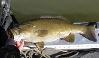
I know it's going to be warmer by mid-week and the fishing will probably improve with the warmer weather, but I just couldn't wait...today was the first day in a long time that I COULD go, and according to the river gages, the Meramec was high, but I figured it would have decent clarity, and the weather was supposed to be clear with fairly light north winds. So I went. Got a late start and didn't get to the river until 11:30 AM. I wanted to go about 5 miles upriver in the jetboat to one of my favorite winter holes, and fish my way back down. But it was darned chilly, so I stopped after a half-mile run and started fishing. Water temp showed 43 degrees, and that was warmer than the air. Visibility was about two feet. Very first cast...14 inch smallmouth. Two casts later, 12 inch largemouth. Both took a jerkbait. I decided to see if they would hit a crankbait, and soon caught another small largemouth before I finished fishing the short stretch of bank that was out of the main current. The current was strong, river up 18 inches or so, and I figured that much of the pool where I had stopped had too much current. I really expected all the fish in the pool to be in this one spot. I was probably wrong. So by now I had warmed up, found a heavier jacket, put on some mittens and pulled my hat down over my ears, and took off upriver. Went all the way past my objective to try a backwater that usually is full of largemouths. There was current coming through the backwater due to the high water level, and there was also another boat farther up the backwater than where I usually fish. At any rate, I caught nothing in the backwater, and went back down to my "all-seasons" pool. I had called it that when describing it (without telling where it is) in my talk at the Smallmouth Alliance banquet Saturday evening, because I've caught big fish there in all seasons. The usual best wintertime spot in it looked great, gentle eddying current just off the stronger main current. But the best log was gone, washed out in recent high water. I immediately started catching fish on a black tube, but they were all small largemouths. In the second best winter spot in that pool, the current was much too strong (I thought). So I went down toward the lower end where I had never really fished in the winter because it's usually fairly shallow and a relatively long way from deep water. I was using the jerkbait, and felt a fish load onto it. I knew it was a good one when I set the hooks. It turned out to be a beautiful, fat 20 inch smallmouth. I snapped a quick photo with it lying on the front of the boat (where I have a ruler taped) and gently released it. Two casts later, I caught a 14 incher. Then a nice largemouth, around 15 inches. It was tough fishing, because I had to hold the boat out in strong current and fish angling upstream, so I didn't really fish that spot the way I would have liked to. I finally hung up, and not wanting to lose a high dollar Japanese jerk bait, went in to get it. The spot was rocky, with a very narrow deep channel along the bank, 6-7 feet deep but only about 5-10 feet wide, rising very quicky to three feet or less as you came out toward the center of the river and the stronger current. Then I went back upstream to the area that I had thought had too much current, and caught two small largemouths on the crankbait. By this time, it was already after 4 PM, and I wanted to fish several more spots before quitting. So I motored back down to the first of them, where I caught three 12-14 inch smallmouths. Then to the second...a couple of smallies of the same size. Then the third...a couple more, same size. By the time I got to the last spot I wanted to fish, it was after 6 PM (glad it's now daylight savings time). I caught a couple more small smallies there, and hooked one more fish that felt like a pretty good one. It hit the jerkbait right against the bank before I had gotten it more than a foot or two deep. But it got off. By the time I loaded the boat on the trailer it was getting dark. Uneventful wildlife viewing day except for a LOT of vultures, and one armadillo rustling around in the leaves on a steep hillside. It never got more than 45 degrees all day, although the water temp actually rose to over 46 degrees by late afternoon. Only one notable fish...but any day I can catch a 20 inch smallmouth is a GREAT day...and this was my first 20 incher of the year.
-
Dan, glad you took my suggestion! By the way...I finally got out today. Remember that spot I described as the "all-seasons spot"? It produced a very fat 20 incher today!
-
Closest I ever came to drowning... Sometime in my early teens, 13 or 14, I was wading Big River with my best fishing buddy. We came to a pool that we knew was too deep to wade from bank to bank. High banks on both sides. Lots of thick brush and itchweed (stinging nettle) on the banks. We knew all this because we had fished it plenty of times before, and suffered each time trying to go around that pool through that brush. So this time, we decided we'd swim it instead. So we take off our tennies, tie the shoelaces together, and wrap them around our necks. Put our fishing rods in our teeth, and start swimming. Now, my buddy was having no trouble making headway, but the stupidest thing I kinda didn't take into consideration was that I also had a stringer of sunfish and the insides to a minnow bucket tied around my waist. So I wasn't going anywhere fast, but I still figured I could make it, after all, it was only 100 feet or so. About 50 feet, at the exact point of no return, I realized I was in trouble. I glubbed a bit and shouted to my buddy that I had to get the bucket off my waist. Took a halfway decent breath and slowly sank while I tried to get it off. Hit the bottom at about 10 feet, and couldn't get it off. Pushed off the bottom, made it to the surface, took a hurried breath and began to sink again. This time I reached the bottom but I was out of breath and no dice getting the bucket loose in my semi-panic. Made it to the surface one more time, choking on water this time, and sank again, figuring this was my last chance to get the bucket off...my buddy was swimming toward me, but he had taken the time to dump his fishing rod and shoes on the bank before turning back and I didn't think he could get to me in time. The bucket was still attached, and just as I was getting pretty sure I wasn't going to make it--funny thing is all I could think about was how mad Mom and Dad were going to be at me for drowning--I felt a submerged limb, which I happened to know was attached to a tree that was attached to the bank. I was able to pull myself up that tree limb and to the bank, coughing an choking and having swallowed a gallon or so of water by the time I got my head to the surface.
-
Good tip on how to set the trap, Bryantsmallie. You HAVE to set it that way to have any success. I can pretty much guarantee that there are stonerollers in any creek that has permanent flow that runs into Norfork.
-
The only thing that makes me question the accuracy of all those statistics is...BOWLING has more participants than fishing????? Who the heck bowls?
-
Missouri Conservationist Insults Hunters And Trappers
Al Agnew replied to vonreed's topic in Conservation Issues
Seems to me that some people just look for a chance to jump all over MDC. I read the letter in the mag, and was somewhat peeved at the woman's attitude. I was not peeved at the magazine for printing it. Nor was I peeved that they didn't jump down her throat (although I probably would have had I been the editor). Not that MDC is blameless and perfect. They've made mistakes, and I believe they've done some things purposely that they shouldn't have done at times. And, since they get all those funds from the 1/8th cent sales tax that everybody pays, they have a broader constituency than hunters, anglers, and trappers. But one thing they haven't done is turn anti-hunting and anti-trapping. -
I keep a daybook in which I put down whatever I do that day, especially the stuff related to my artwork. Hours spent painting or doing other art related things, business trips, shows, reference gathering trips...and fishing trips. I don't get too detailed, just how many fish I caught and any "big" ones, how big they were, what I caught them on, and where exactly I fished. Occasionally, if conditions are out of the ordinary, I might mention weather or water conditions, and in winter, early spring, and late fall I'll mention water temperature. I used to write down a lot of the other stuff, but found that it really didn't tell me all that much when I looked back upon it...I haven't ever come to any consistent conclusions about barometric pressure or moon phase. It's funny how even your own memory will exaggerate the size of the big fish you caught a couple years earlier...that 19 inch smallmouth I thought I'd caught in November of 2004 might turn out to be an 18 incher when I look back through my records!
-
I mentioned this in a previous thread, but thought I'd just put it on a new thread for those in the St. Louis area... The Missouri Smallmouth Alliance will hold their annual banquet at the Knights of Columbus Hall, 1623 Jeffco Blvd. in Arnold, MO, on Saturday, March 8. The banquet is the major fund-raising event for the Smallmouth Alliance, and includes a bunch of stuff that will be offered by auction and silent auction, including rods and reels and other fishing tackle donated by local businesses, guided trips, etc. I always donate a few of my homemade lures for auction, and offer a day of fishing with me in the silent auction. In addition, I'll be the featured speaker this year, with the topic, "Maximizing Opportunities--Ozark Stream Smallmouth Fishing". I'm not sure exactly what I'll actually cover at this point, but it will be geared toward my experience in nearly 50 years of fishing Ozark streams. The public is invited and advance reservations are required. You can get more info on it by calling Dennis Schuetz at 314-838-2789, or Rich Schuppan at 636-493-1817, or visit the alliance website at www.smallmouth.org Click on the link for the Missouri chapter, then on Calendar of Events.
-
Giving A Talk Tomorrow (saturday)
Al Agnew replied to Al Agnew's topic in General Angling Discussion
Brian, that's probably me...what did the painting look like? (I'm the only Al Agnew--artist that I know!) MOFishwater, I'll be the main speaker at the MO Smallmouth Alliance Banquet at the Knights of Columbus Hall in Arnold on Saturday, March 8. Public is invited and advance reservations required. You can get more info on it at www.smallmouth.org Click on the link for the Missouri chapter, then on Calendar of Events. There's always a good turnout at the annual banquet, and there are a bunch of raffle items, an auction, and door prizes. I always put up a few of my homemade lures for auction, as well offering a day of fishing with me in the silent auction. -
Question...are you fishing river habitat, or in a lake? I know something about river walleye, not much about lake walleye.
-
Dano, river smallmouth fishing ain't rocket science. It's actually very simple in some ways, but there are variables. It's simple in that, except on larger streams in the winter months, you've already got one variable solved. Unlike in reservoirs in which you have to find out how deep the fish are and where they are, in our smallish Ozark streams, current and cover are everything, and the fish will be anywhere the current and cover allows them to be. As for depth, the active fish are almost always within reach of whatever lure you wish to throw at them, from topwaters to bottom draggers, and the only depths to AVOID are too shallow for them to swim, and too deep for there to be much food. Don't spend much time in deep water (over 6 feet) because there ain't much smallie food in those places, so whatever smallies that ARE there are going to be inactive, anyway. So, once the water temps get up around 60 degrees or so, usually sometime in April, you'll find smallmouths NEAR fairly shallow water with current (if not IN fairly shallow water with current). The stronger the current, the warmer the water has to be for smallies to be spending a lot of time IN it, but they'll be close. And they'll be in places NEAR, if not in, cover, especially cover they can get UNDER, whether it be logs, rocks, or old Sears refrigerators. And they'll stay in such places, only changing their exact locations in relation to current, until the water starts getting cold again in the fall. So then, the biggest variable still remaining is water conditions, especially how clear the water is. Here's my rule of thumb. Visibility more than 6 feet is "very clear". Visibility 4-6 feet is "clear". Visibility 2-4 feet is "murky". Visibility under 2 feet is "tough". Each division will suggest (not require) different lures and lure colors. This is one place where fly fishermen who have a trout fishing background are often handicapped. Smallies aren't trout. Unlike trout--which tend to zone in on one thing and feed on it to the exclusion of everything else, even if it's a trico hatch and there are nice, fat minnows swimming by them--smallmouths are highly opportunistic feeders whose only criteria for whether they'll eat it or not is that it's alive and small enough to swallow (and even there they sometimes misjudge). So while in clear water they might be willing to eat something small, even there they'll usually prefer something bigger. In murky water, they'll either ignore or simply not notice little stuff. So, for the most part, avoid small flies and lures, the kind of stuff the longear sunfish eat with abandon. Instead of going really small and unobtrusive in very clear water, go bigger. But pick colors that aren't highly contrasting. If you're fishing it on the bottom, make it a color that's close to the color of the bottom (very simple, and very effective rule for several reasons...the natural food will be that color, and the smallies won't be alarmed by some jarring contrast). If you're fishing it close to or on the surface, make it as light and bright as possible (seems counterintuitive, but the fish will be looking UP at it, against the background of the water surface, which is the brightest view in their world, so something that is light and bright will blend right in). And...keep it MOVING. Don't pause it and give the fish a good look at it. This won't always work, and sometimes pausing is the ticket, but it's a good place to start. Very clear water requires stealth and long casts. But the casts don't have to be as accurate, and in fact, if you're using larger lures, aim to land them a few feet away from where you think the fish actually is, and let the fish come to the lure. Landing a big lure on top of a fish in very clear water usually spooks the fish. Clear water, as opposed to very clear, gives a bit more margin of error on the stealth factor, and also gives you a few more choices in lures and colors. While crankbait type lures don't usually work well in very clear water (with a few exceptions), they start to be better in water with a little less visibility. But accuracy becomes a bit more important. Get your lures a little closer to cover. Murky water gives you lots of margin for error in getting close to the fish. But you also have to be accurate with your casts, and you have to know where they are. Murky water, if from a rise in the river, sometimes makes the fish feed with very little caution and move to shallows where they wouldn't ordinarily be, but it can also, especially if the river is dropping fast, position them off the banks in deeper water and make them difficult to find and catch. In murky water, you want bigger lures that make noise and displace water. Crankbaits really shine. Spinnerbaits are great. Topwaters are good as long as they are fairly big. And you want the colors to contrast with the background, especially in lures you will be fishing high in the water column, which in that case means dark colors (contrasting against the light background of the water surface with the fish looking up). Muddy water is tough. Lure choices--keep it simple but cover the entire water column, from topwaters to mid-depth swimmers to bottom bumpers. If spinning or baitcasting, have a couple of walk-the-dog topwaters, a couple of poppers, a prop bait or two, and a couple of smallish to medium size buzzbaits to cover surface fishing. A few spinnerbaits and shallow running crankbaits cover the mid-depths, along with a few soft jerkbaits. For bottom bumpers, a few deep diving crankbaits, some jigs with plastic chunk or crawfish trailers, and an assortment of tubes will work. For the fly rod, hard-bodied poppers, Sneaky Petes, and deer-hair sliders cover the surface. A variety of streamers can be fished at mid-depths. Weighted Woolybuggers are fine for bottom bumping. You can also use a variety of soft plastics weighted with split shot on the fly rod. Lots of fly rod baits will work well, but size is important. If, in general, you're wanting to imitate a minnow, your streamer should be somewhere between 3 and 5 inches long. If imitating a crawdad, your lure should be at least 2 inches but no more than 3.5 inches long. If using a "generic" lure like a Woolybugger, it can be anywhere from 2 to 6 inches long, depending upon how thick it is...long and thin works, short and fat works, short and thin no, long and fat no. The other thing I see fly rodders with the trout background do wrong is, they don't impart enough action in their lures. Dead drifting and dead sticking sometimes works, but usually the smallmouth wants movement. It may just be an occasional lift or twitch as you're letting the lure drift with the current, or it may be hard, fast strips and sweeps. Let the fish tell you what they are interested in that day. Okay, that's my River Smallmouth 101 course.
-
Ask away...we may not be a walleye expert, but we can play one on OA!
-
Just thought I'd drop a line to those in the St. Louis area to let you know I'm giving a couple of talks on Ozark stream fishing from a canoe, at the Great Canoe and Kayak Event put on by the Alpine Shop. The event is at the Kirkwood Community Center, 111 S. Geyer Rd. in Kirkwood. There are a bunch of programs going on both Saturday and Sunday. My talks will be at 11 AM and 3 PM on Saturday, Feb. 9th.
-
Thoughts On Montana? Where To Go? Where To Stay?
Al Agnew replied to OKFlyFisher44's topic in General Angling Discussion
Well, wife and I like Montana so much we bought a cabin out there. In my opinion, the area with the most possibilities is the Livingston area. Not only do you have the Yellowstone River there, you're an hour from Yellowstone Park and its streams, and within an hour in other directions you have choices of several streams, including the Gallatin, Madison, Boulder, Shields...plus a bunch of little creeks that the crowds don't know much about. Lots of guides and outfitters in and around Livingston. -
I love fishing streamers, but on rivers like the Current it's mostly a low-light or murky water deal. When the river is clear and during the daylight hours, catching fish on streamers is usually tough.
-
I'm not sure there is a best section. But I can discuss the different sections: Gruner Ford MDC Access to Syenite MDC Access--7 miles The St. Francis at this point is being fed mainly by Farmington's sewage plant in low summer water levels. It actually dries up completely not far above Gruner Ford in a "losing" reach, although above that reach there is permanent flow and actually some interesting fishing if you can find access (and I ain't gonna tell you the access). So water quality isn't great in the summer and there isn't enough water to float it anyway. In higher spring water levels it's floatable and the sewage water is diluted, so it's pretty decent. No smallmouths in this stretch. No real shut-ins, either. But it still has some rapids that I'd call low class 2 in normal spring water levels, some log jams, and a lot of narrow, twisty riffles. Syenite to Roselle MDC Access at Hwy. 72--10.5 miles About a mile below Syenite you encounter the first real shut-in. The MDC float book says the "river begins to flow more rapidly. Next 3 miles has a gradient of 20 feet per mile." That's kind of an understatement. At the first shut-in the river drops about 10 feet in a half mile. Then it goes through several long, dead pools with short rapids between them for the next mile and a half, dropping maybe another 10 feet at most. That last mile below, it drops the rest of the way, a good 40 feet. The shut-ins are beautiful, but there is a big (and pretty shabby-looking) resort development on the right bank that kinda detracts from the wilderness character throughout much of this stretch. Below there it used to run into the worst willow jungle I've ever seen on an Ozark stream, but the last time I was through there it wasn't nearly so bad. Mostly long pools from there on down. Floatable in higher spring water levels, but you better be experienced in whitewater to do it. In late spring and early summer you can sometimes find it marginally floatable and doable if you're willing to get out and clamber over rocks in places. Class 2 to low 4 rapids, depending upon the water level. By mid-summer, it's a Bataan Death March in a loaded canoe. There are good numbers of smallmouths in the shut-ins areas, mostly largemouths and spotted bass otherwise. Almost every long pool has a school of crappie if you can find them. Roselle to Silvermines USFS Campground--5.5 miles This is the famous whitewater section. In this stretch the river drops 20 feet per mile through 3 separate shut-ins, with short sections of long pools between. The first shut-in starts a half mile below the put-in and goes for a mile or so, and it's the tamest. The second one is Tieman Shut-in at Millstream Gardens MDC area, and it's the roughest on the river, a mile of continuous rapids, including one 4-6 foot drop. The Whitewater Championships are usually held here, and at Silvermines, the third shut-in. The drop through the old Silvermines rock dam is the worst part of that one. This is all class 3 at "normal" spring water level to class 5 in very high water. The water levels are about the same as the stretch above, so it's only floatable in spring water levels, and a real bear to wade or float when it gets low. Hardly anybody floats it to fish it, but wading can produce some smallmouths in the shut-ins sections. Walleye were stocked as far upstream as Hwy. 72, so the long pools could hold some. Silvermines to Cedar Bottom (Hwy. E)--4 miles After the whitewater stretch, this water seems pretty tame, although there are a couple of nasty little riffles. The Little St. Francis comes in about halfway through it, adding some water. It's mostly a mixture of short and long pools, no shut-ins, some pretty sandstone bluffs. It can be pretty good fishing, with a good mixture of all three bass species. I've caught more channel catfish by accident while fishing for bass on this stretch than any other place I've ever fished. Class 1 riffles, with maybe a very low class 2 here and there. The Cedar Bottom bridge has a small informal parking area, but it's mostly highway right-of-way and not a true public access. There is a bit of Forest Service land with rough parking along the highway a couple miles below the bridge that can be an alternate access. Cedar Bottom to the Dug Out Bridge (Highway C--or N, it changes somewhere in that area)--15 miles This is the most remote part of the river. There is no public access between the Forest Service land a couple miles below Cedar Bottom and the Dug Out Bridge (called that because the highway crosses the bridge and "crashes" into a bluff, making a sharp right angle turn to go down the bluff and around the hill). The access at the Dug Out Bridge isn't great, either. It's actually a rough bit of gravel road turning off the highway about a quartermile below the bridge. Parking is tight and the drop to the water is a bit steep. Like the river above, it's got a lot of long pools, but there is one beautiful shut-in with a nice rapid that can be high class 2 or low class 3 at optimum water levels, and the highest, most gorgeous granite bluff to be found anywhere in the St. Francois Mountains. There is also another rapid of similar difficulty a few miles below. The river here flows past the Rockpile Mountain Wilderness Area on the left bank, and there is a limestone bluff with pedestals and natural arches. All in all a very scenic stretch, but one you almost have to float in two days--I've done it in one day during the summer, but it's a daylight to dark thing. Because of the lack of access, the fishing can be very good, with a good mixture of bass species. There's usually enough water to float it throughout June, and if you want to do a lot of dragging you can get down it in all but drought conditions, but trust me, it WILL be work. Dug Out Bridge to Head Ford (undeveloped MDC access)--11 miles There is an intermediate access at Shelton Ford, about 3 miles below the Dug Out Bridge. It's on a county gravel road that fords the river. Head Ford has a nice informal parking area and good access to the river. The river in this stretch is floatable most of the summer, and sometimes has enough water for jetboat use, but there are still tight turns and sharp drops that limit the jetboats. And it gets low enough by late summer that you'll still be dragging a lot of riffles. There are no real shut-ins, but still a lot of granite outcrops and sharp-dropping riffles. But the gravel bars are bigger and the river looks a bit more like a normal Ozark stream. Good fishing for all three bass species, walleye, crappie in the big pools, and catfish. Head Ford to Sam A. Baker State Park--11 miles There is a canoe rental in the park that puts in floats about 6 miles above the park, but it's not a public access. Big Creek, the highest volume tributary, comes in at the upper end of Sam A. Baker. This stretch is similar to the one above. While the canoe rental doesn't mind putting in novice canoeists, a lot of them end up wet by accident, because while there are no rapids, the riffles can be tight, partially log-jammed, and difficult. Sam A. Baker to Wappapello (U.S. Highway 67 bridge access)--12 miles There is intermediate access at Highway 34, 3 miles below Baker Park, and at several other points. The river is a bit bigger down here and always floatable, but still has some tricky riffles. It's often but not always runnable by jetboats. The smallmouths start to disappear through this stretch. The good access and size make it the most heavily fished section of the river, but it can still be good fishing. Wappapello backs water up to about 2 or three miles above Hwy. 67 at normal pool. Wappapello Dam was built at the farthest downstream place possible, right where the river leaves the Ozark hills and spills out onto the flatlands of the Bootheel. So the river below the dam is a slow, winding, swampy Mississippi Delta stream. The St. Francis's one big spring, Davidson's Blue Spring--one of the 15 largest springs in the state--was inundated by Wappapello. The Little St. Francis is marginally floatable from Fredericktown down, a distance of 15 miles. It's a spring or high water run, but can be float-waded in summer if you're willing to work at it. Accesses are at Highway 72 (poor access and difficult parking), MDC Thompson Ford access 5 miles below, and a concrete slab ford 4 miles below Thompson Ford. The next access downstream is on the St. Francis at Cedar Bottom. The Little St. Francis, true to its name, is like a smaller version of the St. Francis, with shut-ins, a beautiful granite bluff, and long pools. It's class 3 through the upper shut-in, class 2 at optimum levels along the granite bluff near the mouth. Smallmouths are present but not real common--the other bass species are plentiful. Big Creek is the other big tributary. It's a lot different, being a very clear, fast creek with a lot of gravel. It has one beautiful shut-in with low class 2 rapids. It's floatable from Hwy. K, a distance of 19 miles, with accesses at Hwy. 49 and Hwy. 143. It's usually floatable from Hwy. 143 until early summer. It is mostly smallmouth water.
-
Those of you who are familiar with Ozark streams but haven't been on the St. Francis would find it to be VERY different from the "normal" Ozark stream. This is due mostly to the geology through with it flows. As it says in the introduction, the St. Francis heads up in the St. Francois Mountains (and yes, the two different spellings are correct--although the river can be spelled either way, it's usually spelled without the "o", while the mountains and the county are spelled with the "o"). To truly understand the St. Francis, you have to understand a bit about Ozarks geology. The St. Francois Mountains are the geologic center of the Ozarks (though of course not the geographic center). The Ozarks are basically a gently uplifted plateau--or actually three plateaus--that has been eroded by the streams draining it. That's why the hilltops over most of the Ozarks are all about the same height--their tops are the remnants of the original plateaus. As I said, there are three separate plateaus in the Ozarks. The highest is the Boston Plateau, called the Boston Mountains, in Arkansas. It's made up mostly of Pennsylvanian rocks lying atop Mississippian rocks. The second highest is the Springfield Plateau, which makes up much of the area in the upper White River country and the Springfield area. It's made up of Mississippian over Ordovician rocks. The lowest, which covers much of the Missouri Ozarks, is the Salem Plateau, which is made up of Ordovician and Cambrian rocks. Now if you know your basic high school geology, you'll know that Pennsylvanian sediments lie over Mississippian over Ordovician over Cambrian, with Precambrian lying beneath all of them. Drill a hole deep enough through the Boston Mountains and you'll eventually get to Precambrian rock. But since the Ozarks have been uplifted and eroded, the closer you get to the center of the uplift, the closer the Precambrian rocks are to the surface. And in the St. Francois Mountains they are exposed, with all the other rocks eroded away. The Precambrian rocks of the St. Francois Mountains are usually called granite, although they are mostly not true granite but other igneous (volcanic) rocks. What all of them have in common is that they are very hard and resistant to erosion, compared to the sedimentary rocks around them. So a stream that flows through igneous rock, unlike one flowing through the sedimentary rock of the rest of the Ozarks, cannot carve out wide valleys. And what this means to the St. Francis River is that, wherever it encounters igneous rock, the valley pinches in, gets narrow and V-shaped. But what you also have to consider is that, not too many millions of years ago, those igneous rocks were still covered up by sedimentary rocks. They weren't a flat surface, but consisted of buried knobs and valleys. The St. Francis then flowed over the sedimentary rocks in a typical meandering Ozark course. But as it wore away the sedimentary rocks, it began to encounter the buried Precambrian. Those hard rocks actually formed "dams", backing up sediments behind them, with the river eventually pouring over them and starting to wear through them. Topographically, the St. Francis flows for a while in wide, flat valleys between low sedimentary hills, then encounters one of those Precambrian outcrops and pours through it in a V-shaped canyon with a lot of fast water, then slows down again when it comes to the next sedimentary rock valley. The narrow canyons are called "shut-ins". Johnson's Shut-in on the East Fork of Black River is probably the best known, but the St. Francis has more, longer, and arguably more spectacular shut-ins, and that's what makes it a great whitewater river when there is enough flow. While the average floatable Ozark stream drops somewhere between 2 and 8 feet per mile, the St. Francis drops 20 feet per mile in two different 3-5 mile stretches. And in the shorter stretches of true rapids it drops a lot more than that. The only problem with the St. Francis as a whitewater river is that it just doesn't have a dependable water supply. The same geology that gives it the shut-ins is not conducive to supplying it with a lot of springs. It will usually be flowing enough water in the spring, though not always. But in the summer it often drops to less than 50 cubic feet per second even far downstream at Sam A. Baker State Park. So for the angler, the St. Francis is not a real convenient river to fish. If there's enough water to float it, some stretches are dangerous. If it's low, it's almost unfloatable. Wading is problematical because those igneous rocks are rounded and usually SLICK, with deep holes between them. Only one canoe rental services the river, at Sam A. Baker. Not much of it is normally jetboatable. I've fished the entire length of the St. Francis above Wappapello. It's different in the composition of fish species (especially bass) as well. There are few if any smallmouths in the upstream end, above Farmington. Smallmouths don't really get common until you hit the first real shut-in stretch, above Hwy. 72. Largemouths are more abundant on the St. Francis that any other Ozark stream, and spotted bass are common throughout. For unknown reasons, smallmouths have actually become a lot more common than they were 30 years ago. Back then, you very seldom caught smallmouths anywhere on the river, but now they are quite common in fast water areas. The river consists of a lot of long, dead pools, separated by riffles that are often willow-choked and rocky rapids that are usually tricky to float. The water is seldom truly clear, and often very olive green to olive brown in the summer. Bass fishing on the St. Francis seems more of a feast or famine thing to me than other streams. When it's right, it's terrific. When it's not right, you'd swear there weren't a dozen bass in the whole river. As for other fishing...catfishing is excellent over most if not all the river. There are walleye in the St. Francis, thanks to a stocking program by MDC that has tried to replace the vanished native walleye which once produced some big fish, including a former Missouri record. Sunfish and goggle-eye are abundant, and the St. Francis may be the best crappie river in the Ozarks. And if you like a different challenge, there are a LOT of big gar. Some years there's a white bass run out of Wappapello, but it's very inconsistent. I love fishing it, however. You have to pay in effort and sometimes bruises to fish the St. Fran. I've encountered worse willow jungles on it than anywhere else. I've fallen on rocks, twisted ankles, crashed canoes, lost rods. But the shut-ins and the granite bluffs and the rapids make it worthwhile even when the fish aren't playing.
-
Personally, I haven't spent enough time on the St. Francis to know much about it firsthand. For a while, from what I've been told, things looked good, but MDC couldn't get a good handle on how the original plantings were doing. They had hoped to do some shocking on and around possible spawning riffles, but everytime they tried it the weather and water conditions didn't cooperate. You're right...they did it right. They took the native fish from Black River, right next to the St. Francis, and they did well in the difficult job of hatching and raising them. I had high hopes for the St. Francis walleye, and maybe they'll still make it. From the beginning of stocking back in the late 1990s until 2003, you couldn't keep walleye on the St. Francis. In 2003 they opened the fishing with a four fish, 18 inch limit. They were seeing some evidence of natural reproduction, but personally I think they should have kept a bit more protection on the fish. I know of several people around here who have caught the usual one or two walleye while fishing for other species, but if anybody is regularly catching walleye from the St. Francis these days, they are keeping it quiet. I hope that's the case.
-
Mark... I'm probably not the best person to talk to about Colorado...some of the other guys on here probably know a lot more about it. I've only fished in a few places in CO, since I like Montana so much better. Problem with CO is that their stupid stream access laws make the public water somewhat limited and thus crowded...at least every place I've been in CO was crowded.
-
As I wrote in my Ozark walleye post, there WERE walleye in the White River system prior to the building of Bull Shoals Lake, and the book I quoted has reports of them being caught in the James River in the 1920s and 1930s. Apparently, however, they were rare. You would think that giggers would have taken more walleye if they were at all common. However, they may not have been as rare as we might think. The tactics and lures used for catching bass in the White and other Ozark streams back in those days would not have lended themselves to catching walleye with any regularity. Those of you who fish rivers like the Current, Black, Meramec, and Gasconade could ask yourselves how many walleye YOU'VE caught by accident while fishing for bass. The answer, I'm sure, would be few to none. In all my years of fishing Ozark streams, while fishing for bass I've caught, as near as I can remember, two walleye on the Bourbeuse River, four on the Meramec (two in one day this past autumn), one on Big River (a couple years ago, and Big River is my home stream and I've fished it for nearly 50 years), several juveniles on Saline Creek, a half dozen or so on lower Black River, and that's about it. And yet we know there are breeding populations of them on all these rivers. And even the giggers, back in the old days, probably didn't do much gigging on the White river system when the walleye were most vulnerable. Ozark river walleye are early spawners, staging near spawning riffles starting about mid-February, and pretty well finished spawning by early March. So you would have had to be gigging at night in late February to really have a good chance of seeing a lot of walleye. Otherwise, you would be gigging when the walleye were widely scattered and likely in water too deep to gig. The key is that walleye are almost totally nocturnal feeders in the summer when most Ozark float fishing was done, and spend most summer days in deep water. According to one old guy I knew on Current River who spent a lot of time studying them, they hang out in the deepest parts of pools during the daytime in warm weather, right where the rocks coming off the talus slope of the bluff meets the gravel of the other side of the pool, well off the banks toward the middle of the pool. Back in those days, and even today, most floatfishermen fish the banks for bass, and the boats would be right over where the walleye would be. And most bass lures back in those days were meant to be fished shallow, anyway. So it's no surprise to me that very few walleye were caught by the old time floatfishermen on the White. They were probably never common, but they were there. As for sauger, I've caught them while walleye fishing on the lower Black River, and also in the Diversion Channel. Compared to walleye, they are not as common on the Black, but there are enough of them that it's no surprise to catch one.
-
Just a little more about shadow bass and the other rock bass species...used to be that we all thought there was just one goggle-eye species in MO, but there ARE major differences even in the appearance of the three different species. Which one you are catching depends on which river system you're fishing. Osage, Gasconade, and Meramec river systems, it's a northern rock bass. Current, Black, and St. Francis river systems, it's a shadow bass. White River drainage, it's an Ozark rock bass. However, the northern rock bass was not native to the Gasconade and Osage systems, and got there by stocking a long time ago. And some other streams have been stocked at different times with non-native species, so there are hybrids in some streams. Shadow bass hybridize readily with northern rock bass, but Ozark bass apparently do not hybridize with the other species. If you know what to look for you can tell them apart by appearance. Northern rock bass have well-defined, continuous rows of very dark spots on their sides, pretty much a spot on each scale. Shadow bass have a camoflage pattern of big, dark blotches, and the black spots are only within the blotches. Ozark bass have more scattered black spots, with no particular rhyme or reason where each one is.
-
SIO3, yes, that's the Diversion Channel. Castor and Whitewater used to flow straight out of the Ozark hills into the flat, swampy land of the Bootheel, and continue down all the way into Arkansas before getting to the Mississippi. Castor cut through Crowley's Ridge just north of Bloomfield and continued south, while Whitewater split into two channels and then came back together to form Little River. The two finally merged a bit north of New Madrid. In the flatlands they meandered and had a lot of side channels and flowed through a lot of wetlands. In order to drain the wetlands for agriculture, the Diversion Channel was built, starting at the point where Castor emerged from the hills. I believe it was completed around 1900, but I don't remember for sure. It starts where the Castor emerges from the hills at the little town of Greenbrier, and runs along the edge of the hills, gathering Whitewater and other smaller streams emerging from the hills, running to the Mississippi between Cape Girardeau and Scott City. I fished it quite a bit when I was living in the area. I never caught any hybrids, but caught lots of white bass. There are also a lot of catfish, and some spotted bass. You can Google "Headwaters Diversion Channel" and get several listings for information on it, from Wikipedia and MDC among others. The MDC info said nothing about either white bass or hybrids. The white bass fishing was always a spring-time thing as they made a run up from the Mississippi. According to the Wikipedia entry, it was built between 1916 and 1920. Another interesting thing that I noted was that the Little River, which Castor and Whitewater merged to form, flowed parallel to the Mississippi and actually entered the lower St. Francis River in Arkansas rather than directly into the Mississippi. Therefore, Castor and Whitewater were originally part of the St. Francis River system, and the originally native walleye were probably similar to St. Francis walleye. However, the Diversion Channel fish are likely coming up from the Mississippi these days.
