


hank franklin
-
Posts
532 -
Joined
-
Last visited
Content Type
Profiles
Forums
Blogs
Events
Articles
Video Feed
Gallery
Everything posted by hank franklin
-
I'm an Oilers fan, not a soccer man. My arms are red and so is my blood. Sorry.
-
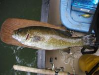
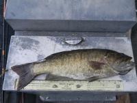
My favorite yet is the one in the video on the Current. This was my 20-incher, caught on the Meramec with a white fluke. Here's Mr. 21, also caught on a white fluke.
-
Awesome awesome.
-
Yeah, when I first got into fishing this was one of my go-to haunts. This was early to mid-late 90's, it was very consistent and I pretty much always caught fish. The water right at the foot of the Suicide trail almost always gave up something. The reach from Suicide up to the gravel bar pictured above was my favorite, you could fish through there all day and catch em consistently. I also liked to walk in at the Spring park and then bushwhack downstream. Here again, very consistent and often with big numbers. About mid-way between the spring and Dry Fork used to be a deeper shelf type of feature, one year I caught them by the handful off there, one after the other, including the biggest trout I ever caught, a 24-inch or so rainbow that I released. One of my first big smallmouth was also caught through there, on river right against a cut bank in 4-foot of water. The cut bank remains but the deep chute is filled in. The area above and below Dry Fork of course used to be never-fail. Just below the Dry Fork entry used to be a very deep hole; it's still there (or was last year) but it is not as deep as it used to be. One year we hit it just right and literally caught them one after the other. Not sure when the fishing went south, maybe mid 2000's or so. The last several trips it seems have been very poor. No idea why. Probably the most disappointing to me is the stretch below the spring to Dry Fork used to be much richer in terms of habitat and fishing features. Deeper holes, deeper flowing chutes, etc. Maybe it's low water or just selective memory or what but it seems this stretch is just flat, shallow and feature-less these days. I'd be interested to hear if others have had the same experience.
-
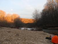
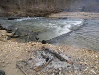
Nice report, I imagine you saw eagles? Looking forward to the pictures. I didn't make it down. I always get confused with Cardiac and Suicide. I've actually never walked in from Cardiac, always Suicide. Suicide Hill thus is visible in this photo, the far-off ridge. I'm not sure where the Cardiac trail actually hits the Meramec. So in this regard maybe this chute is below Cardiac, though it's clearly above Suicide.
-
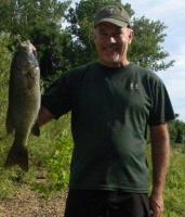
I have one 21-inch and one 20-inch. Fortunate to have caught them both. Both were exactly 21 and 20, tip of nose to tail pushed together. Both on the Meramec, though far apart. A 20-inch stream smallmouth to me is the Holy Grail of Ozark stream fishing.
-
The river is at a pretty good stage right now, (153 cfs Cook Station, 651 cfs at Steelville) actually probably ideal for floating. Probably discolored just a bit. Only drawback is wading at this stage can be a bit iffy, especially if you're trying to cross back and forth. I may be down there myself on Sunday. Good luck.
-
Either the Hog Trough Road to Tea Access or Tea Access to Shawnee Ford Rd floats can be good in spring. My favorite stretch is probably Wenkel Ford to Peters Ford. In higher water you can run Mt. Pleasant Ford to Mint Springs which I've found to have great Ozark character. Good luck.
-
Matt, No pics of any consequence, nor any pics of any fish. I think I mighta got one or two that trip. The river gets slow in the reaches above Scott's Ford. I would definitely concentrate most of my fishing above Cardiac. Yes, please post a report. I'd be interested to know if that chute I referenced above has been cleared.
-
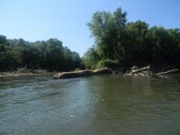
I too have been eyeing it. We floated overnight January 2012 with Steelville gage at 346 cfs, it's 396 today. At this level it's still pretty skinny above the spring but doable. Once below the spring you should be fine. There was a quite impressive rift on the bend above Cardiac that we had no intention of messing with it all w our loaded canoe. Instead we portaged around through the very skinny and trickling channel divide to river right. Photo below. The rift itself is not the problem but the big log just below. I did not want to take the chance of wrangling with him. The fishing was bad on this trip but the river itself I find to be beautiful. Bald eagles in abundance.
-
Sounds great. Hawn is one of Missouri's jewels.
-
Looks like one of them sassafras paddles. Made by some guy out of Mountain Home if my eye don't deceive.
-
Why Cant The Media Cover This
hank franklin replied to Feathers and Fins's topic in New News and General Discussion
If my local school district wanted to bring in a police officer on occasion to talk to kids about gun safety, I'd say sure, go for it. Oh, wait, my local school district already does that. What I object to is making this a STATE LAW. Is the DARE program a state law? No. Lots of schools do it but it's not required. When it comes to schools I am all about local control. This is one more intrusion on that. Secondarily, it seems the fine senator's proposal is a perverse argument for more gun control. If in fact the STATE needs to teach kids about gun safety because the ignorant parents can't do it for themselves, then what right does such an ignorant parent have to a gun in the first place? -
Why Cant The Media Cover This
hank franklin replied to Feathers and Fins's topic in New News and General Discussion
Uh, my point exactly. -
Why Cant The Media Cover This
hank franklin replied to Feathers and Fins's topic in New News and General Discussion
I seem to recall mentioning this to my kid a time or two. See gun, stay away. Guns bad. Not for kids. Don't touch. Guns go boom. I think I as a parent can handle this one. -
Why Cant The Media Cover This
hank franklin replied to Feathers and Fins's topic in New News and General Discussion
So what do we make of this Dan Brown character in Rolla, MO, a MIssouri state senator who wants the state (vis a vis) public education, to teach first graders about gun control? http://gasconade.countynewslive.com/content/regarding-senator-browns-bill-would-mandate-1st-graders-receive-firearm-training-public-scho The nanny-state on steroids. Don't worry about teaching your kids about guns, our first grade teachers will do it fer ya! Are you freaking kidding me? Will the nanny-state wipe my child's butt for me too? -
Also, I agree that a slip and fall, broken ankle, etc. is a real hazard. If you're out alone, an ounce of prevention...just don't do something stupid. I've also become a stickler for maps. They are easy to get from Internet sources and with a compass can keep you "in contact." I will not go on a journey of any length without a good map.
-
I carry a change of clothes pretty much everywhere. UnderArmour shirt, packable rainpants. I have a small magnifying glass to supplement matches and lighter. All my survival gear goes in a small waterproof bag. If I flip my canoe it's the first and theoretically only thing I'd need. It rides right at my feet. I sometimes clip it to the boat but mostly I just let it ride. When backpacking I usually transfer all the gear into a large ziploc bag or two. Again, key is to keep the stuff dry. My closest encounter with backwoods danger came as a young guy hiking the Smoky Mountains. 3-night hike. Night one was fine. Night two started fine but after bed unexpected rain came. A lot of stuff stupidly was left out and drenched. We waited in the tent under rain until mid-morning and then packed up wet in a small break in the rain. Pretty much everything was wet, tent floor was soggy and the sleeping bags got in it. The clothes we were in were dry enough; change of clothes had stayed dry through the night (in a stuff sack used for a pillow) but we changed into dry clothes as we packed up and by mid-day with heavy rains back on we were soaked again. It was probably 50-ish but we were stating to chill and rain was not abating. By mid afternoon we had a decision to make, try to push out or hope for the best. We were pretty deep in and not exactly confident in the map, and had an idea to push for one of the bear shelters or whatever those raised platform cage things they have there. Fortunately by late afternoon the rain abated and we took the first chance we had to put up camp and try to dry out. We gathered enough dry stuff and soon enough had quite a good fire. For whatever reason I've never had much trouble starting a fire, you can always find dry stuff in the woods if you look. Long story short the worst part of the trip was trying to get back to dry clothes. In soggy clothes we were basically screwed, without fire we really would have been on the edge. The semi-dry clothes dried well enough once we put them back on and hung around the fire. But literally nothing in the camp ever really got dry. The sleeping bag in particular was spongey despite efforts to dry out. Yuck. It all turned out well enough, the next morning was glorious, but we really were on the edge for a period. Without fire ability and dry clothes we wouldve been up against it. Stay dry my friends!
-
Nice.
-
What Should We Do About Mass Shootings?
hank franklin replied to jdmidwest's topic in New News and General Discussion
Schools are run by the local communities. In our small town we're having a debate over spending for more security, whether it be a SRO (don't have one) or improvements to the buildings, or something else. There's no way you can "fortify" our buildings, but you can take some modest steps. Best we can do. Don't know if we'll get the SRO or not. $50K budget and in a small town that's big bucks. So if the feds edict that you must fortify your buildings, or hired an armed guard (SRO), do we genuflect to the feds and pay up? A federal edict in this area is just that, a federal edict and more federal CREEP, which is the last thing we need. So many problems. The media lives for blood. Hollywood violence is entertainment. Munch your popcorn and watch people die! Gun nuts are tripping over each other ammo-ing up and now and then a stray bullet gets loose, whoops. Obama=Hitler. I'm a rural conservative Republican but my "leaders" (such as they are) are primarily shills for the billionaires who fund them, this is true at federal and state levels. Obama is a stuffed shirt and the federal government underneath him is absolutely sucking the lifeblood from the country. Yet we conservatives are sliding downhill. Why? Look yourself in the mirror sometime. Sorry to bluster. -
I love this topic. Here's a couple pics of the confluence from July 2011. This pic shows that clay bank peninsula I was talking about. It must be gone now, doesn't show on the most recent June 2012 Google Earth aerial. This is a view from downstream. From this perspective it seems the river may rush directly over and connect with the old Huzzah channel. It seems inevitable that we'll eventually get an island here, with the old Huzzah Channel as the outside bend and the current Meramec channel as the inside? Fascinating. I guess I'm a river geek. Going back to your Horseshoe above Hamilton Creek, this is before my time and I never knew it was there. However I have of course walked Hamilton Creek and been a little perplexed by the nearby slough, which shows on the recent aerials. Wonder what might be a remnant of? The topo you posted above shows it as an intermittent stream however the aerial doesn't give a good indication.
-
Al, thanks very much for your post above. I have been amazed at how quickly the channel change above Green's Bluff has happened, literally the last couple years. The right channel for years was dominant but now the left channel is. We camped at the head of that island in October and there was not enough water on the right channel to float a canoe. One positive aspect of this is it makes Green's Cave less accessible; you will miss it if you don't know it's there. The old right-hand channel of course dropped you right at its feet. Meanwhile, at the Huzzah-Meramec confluence, it appears that the last of the thin peninsula there has caved in. If you look closely at the aerial now it seems possible that the river may actually reclaim the old Huzzah channel left behind years ago, now that the last bend before the Huzzah has been eroded through. Which way will the river go, will it stay left or go right? What do you think?
-
Smallmouth Bass Management Update - Jan 16Th
hank franklin replied to Dan Kreher's topic in Smallmouth Talk
I have followed this issue from afar for the 20 or so years I've been serious smallmouth bassin. Kudos to the Smallmouth Alliance for their continued focus on this. Without them I'm not sure if MDC would be paying much attention at all. It is terribly frustrating to me as a smallmouth angler that MDC has made so little progress. Yes we have seen some management areas introduced but very little if nothing since. My perception as a distanced observer is that there's a political calculation in all this. There's an urban / rural split in Missouri politics, and I believe MDC sees the 12 inch 6 creel reg as the "rural" position. The urban/suburban smallmouthers are all catch and keep environmentalist liberal wackos. So MDC for political reasons is not going to side with the urban / suburbans. I think Bob Todd's op-ed piece in River Hills Traveler a couple years back is a perfect example of this. Bob basically played the "dont tread on me" rural card. The MDC I think is not treading on him for political reasons, not science. Excellent point on angler point restrictions. I think 4-pt rule is ludicrous actually. Why did MDC act so decisively? Because the big buck constituency wanted it, and who's going to argue with big bucks? No urban rural split here. My two cents. Once again, kudos to Smallmouth Alliance for all their hard work. -
The Ozark trail maps clearly put the total roundtrip distance at app. 16 miles. Too much for one day with young children. I wonder if he had a map. It would appear from this map that at Mile 93.5 he could have went down the "Missouri Branch" creek hollow along a rough logging road. This would have got him "out of the woods" so to speak. Yes, possibly flash flooded but structures are shown on the map in near vicinity. If I was in trouble at that point that's likely what I would have done. Did he have a map? I haven't seen this referenced. To be on a 16 mile hike without a map, not good.
-
I had a hard time believing the story at first but it's very likely classic hypothermia. They got soaking wet, cold set in, and they had no way to warm up. No light, no fire, lost in the woods. Early hypothermia makes you confused, erratic. They were physically spent from the day on the trail. With mental capacity dwindling and body temps dropping they got to a point of no way out. If they had ability to start a fire, if they had one change of clothes, they probably would have survived. It's the combination of wet plus cold (and it doesn't need to be freezing cold) that did them in. Very sad story. I have kids who have accompanied me floating / hiking during all seasons. The thought of the fun and excitement these kids were having suddenly turning terribly wrong is really heartbreaking. It can happen. Be careful. For the floater / hiker, the biggest danger is rain. Camps that get flooded overnight on the river. Backpack camps that aren't prepared for huge rain. You always need to consider the worst-case and what you do for escape. I have been out for 3-4 days at a time and the number one thing is staying dry. If not you, then at least your gear. Heartbreaking.


