
Phil Lilley
-
Posts
19,030 -
Joined
-
Last visited
-
Days Won
132
Content Type
Profiles
Forums
Blogs
Events
Articles
Video Feed
Gallery
Everything posted by Phil Lilley
-
Have no idea. It may. But then the gates might be shut down - may be that day. The water is getting clearer by the day.
-
They've said they'd run this till Table Rock gets to 920. It's dropping almost 9 inches a day now so it could be down by next weekend??? Unless they start dumping Beaver
-
BS is at 684.44. No slow down in sight. I bet the Corps isn't worried about BS since they're able to run up to 6 units now.
-
All ramps are open. Not sure about Rockaway though.
-
Ok... here's the skinny. The guys had a tough time yesterday. Between water levels, speed of current and dingy water color, it was hard to get the lure or bait down to the fish. Lots of rigs and jigs lost. But there were some good trout caught. The guys who did the best either tied up near the bank or in the mouths of creek, out of the current, and fished white jigs, minnows and night crawlers. Others drifted and worked inside bends with small crank baits or white jigs. Some drifted Powerbait on the bottom and did well, but they stayed on the inside bends. Best area was between Fall Creek and Short Creek but guys did well around Monkey Island and even further down. Shad were seen in the water as far down lake as the Landing. They were small threadfin - about an inch long. Today- our water color looks much better for some reason. I'd say visibility went from 24 to 36 inches.
-
I'm only going to post the results right now. Will comment on details later this afternoon.
-
Does that mean I have to go fishing everyday? I wish
-
Just got off the lake. Tried a few things - some worked and some didn't. Stayed on the outside bends from Fall Creek to our dock - that's almost a no brainer. Current is too fast to fish the outside bluff banks. Some places on the inside are pretty slow which I think the trout like. I did the best throwing a 3/32nd ounce marabou jigs, 4 pound line, keeping the boat about 3 boat lengths from the bank and throwing to the edge. The water is off colored and it's hard to judge the bottom, plus there's some downed trees on that bank but you have to get your jig down fairly deep to get bit. Unfortunately, you'll lose some jigs. I did the best on white but did catch a few on sculpin colored jigs.
-
Ha Ha... there is no 1.5 feet unless you're 1.5 feet from a bank Water will be this high for several weeks.
-
You crack me up...
-
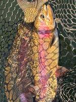
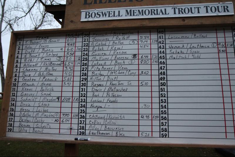
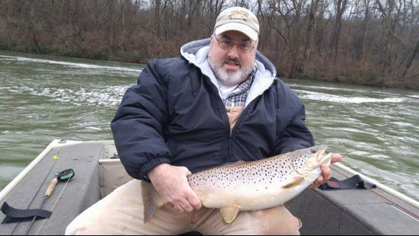 The annual Boswell Memorial Tournament is Saturday and already the dock is full of boats, here to practice for the contest. This group of anglers have been coming together to fish and fellowship for over 30 years and each year they never know what to expect, fishing in January, the dead of winter. This year is no different, but they are being greeted by something different-- flood gates and off colored water. Snow they're use to, cold they're used to, but not this. "No one knows how to fish this", said one angler just arriving in the parking lot. Others have said the high, fast water is pretty intimidating. Some in smaller boats want to find a place out of the current and try their luck there. That may be the ticket too -- getting out of the current. In the past, that's usually where you'll find big numbers of trout -- in the creeks out of the fast current. Today was tough. That's what most of the guys said when I talked to them this evening. But yesterday, some of the same anglers caught quite a few fish so it may be just one of those days the fish didn't bite well. But tell that to Don Collins and Mark Mazdra. They have been fishing together in the Boswell contest for many years. They chose to boat to the dam and throw white jigs and look what they caught. You can see how fat these fish are. The big shad run I saw was almost 10 days so either these fish are finding more things to eat or they're still seeing shad. The next couple of days should tell me a lot about the fish, and fishing conditions of the lake. Stay tuned.
 -
The annual Boswell Memorial Tournament is Saturday and already the dock is full of boats, here to practice for the contest. This group of anglers have been coming together to fish and fellowship for over 30 years and each year they never know what to expect, fishing in January, the dead of winter. This year is no different, but they are being greeted by something different-- flood gates and off colored water. Snow they're use to, cold they're used to, but not this. "No one knows how to fish this", said one angler just arriving in the parking lot. Others have said the high, fast water is pretty intimidating. Some in smaller boats want to find a place out of the current and try their luck there. That may be the ticket too -- getting out of the current. In the past, that's usually where you'll find big numbers of trout -- in the creeks out of the fast current. Today was tough. That's what most of the guys said when I talked to them this evening. But yesterday, some of the same anglers caught quite a few fish so it may be just one of those days the fish didn't bite well. But tell that to Don Collins and Mark Mazdra. They have been fishing together in the Boswell contest for many years. They chose to boat to the dam and throw white jigs and look what they caught. You can see how fat these fish are. The big shad run I saw was almost 10 days so either these fish are finding more things to eat or they're still seeing shad. The next couple of days should tell me a lot about the fish, and fishing conditions of the lake. Stay tuned. View full article
-
- 2
-

-
My guess... July!! By then we'll see the bottom of the lake - may be.
-

Corps statement from their Facebook page
Phil Lilley replied to Quillback's topic in Table Rock Lake
In 2011, after the rains stopped, it didn't rain all summer... flood turned to drought. We need cold weather... snow is better than rain. -
Copied from a thread on Table Rock. It has the same importance to Taney. Here's the most recent UPDATE I've received from the Corps- Table Rock surcharge release ended 31 1800 Dec 2015. Currently releasing 20,000 cfs and will do so until Bull Shoals gets to 684 elevation. Bull Shoals is currently 681.69. Beaver passing inflow with double firm power generation equivalent, 2000 dsf, according to the water control plan. Table Rock continuing its routine release of 20000 cfs continuing to evacuate storage. Bull Shoals continuing to rise as releases are restricted by downstream conditions. Rainfall/Forecast. Rain returns to the forecast starting Wednesday and remains in the forecast through Sunday night. Next forecasted rainfall includes 1.4 inch rainfall depths for Little River Basins and 0.75 inch to 1 inch for all other SWL basins starting Wednesday this week. 7-Day QPF is: http://www.wpc.ncep.noaa.gov/qpf/p168i.gif?1451913322 RISK ASSESSMENT. (AMBER) District Wide Flood Storage - with all Flood Risk Management Projects using flood storage. We are very concerned about the impacts of future rainfall as we look ahead to our rainy season. SWL begins 2016 with the White River System storage at 63%. Forecasted rainfall will slow current flood storage evacuation efforts and possibly return Beaver and Table Rock Lakes to rising pools requiring increased releases to crest pools at or below the top of their respective conservation pools. (AMBER) Table Rock is below its top of flood pool and continues to fall slowly, releases steady at 20,000 cfs. Weather forecast is favorable to evacuate flood storage for the next 3 days. Rainfall forecast for about 1 inch over four days beginning Wednesday, this event could cause a rising pool and require increased releases. WHITE RIVER SYSTEM. Beaver will have a steady to slow falling trend. Table Rock is falling slowly. Bull Shoals is continuing to rise and will continue this trend. BS and NF are restricted to firm power release because Newport gage remains above regulating stage; plan to initiate secondary releases by mid-week. GF is still restricted to firm power release because of downstream conditions at the Georgetown gage. Beaver: elev 1129.12 (90% fs) and holding; release is double firm power generation equivalent, about 2000 dfs. Table Rock: elev 929.7 (91% fs) and falling ; releasing 20K cfs. This release will continue for several weeks. Bull Shoals: elev 681.65 (58%fs) and rising ; restricted to firm power (3750 dsf) release. Norfork: elev 571.14 (63% fs) and cresting; restricted to firm power (1300 dsf) release. Greer's Ferry: elev 474.79 (48% fs) and cresting; restricted to firm power (1200 dsf) release. Current stage at Newport is 28.62' and falling; crested at 32.26 ft on 12/30 (21' regulating stage). Current stage at Georgetown is at 27.48' and falling; crested at 27.97 Saturday night (21' regulating stage). Table Rock has dropped from 929.53 to 929.04 in the last 24 hours. Bull Shoals has risen from 681.81 to 682.42 in the last 24 hours. When BS hits 684 feet, they will cut back Table Rock's flow - to what I don't know. The levels to watch is at Newport and Georgetown. http://www.srh.noaa.gov/lmrfc/ This shows the Mississippi continuing to rise. They're not going to let go of any water here until these levels drop. You have to look at all the lakes in the White River chain as one lake... we're in a holding pattern and will continue to be in one until - #1. the Mississippi goes down or #2. we get a bunch more rain and they have to dump. I don't see this changing for at least a week or two. One to 1.5 inches forecasted for Thursday and Friday. Our water clarity changed a few nights ago. It's now a dingy green color- about 24 inch visibility. While this should not affect fishing, it will affect how the fish see lures and bait and I think they will become more aggressive. The change was cause by Table Rock turning over - that's what Shane Bush thinks. He's MDC fisheries biologists for Taney and Table Rock. Before the rains, Table Rock had not fully turned over. This explains why the water coming over the flood gates right now is clear and the water from the turbines is off color. It should clear up gradually as time goes on.
-
Corps statement from their Facebook page
Phil Lilley replied to Quillback's topic in Table Rock Lake
Table Rock has dropped from 929.53 to 929.04 in the last 24 hours. Bull Shoals has risen from 681.81 to 682.42 in the last 24 hours. When BS hits 684 feet, they will cut back Table Rock's flow - to what I don't know. The levels to watch is at Newport and Georgetown. http://www.srh.noaa.gov/lmrfc/ This shows the Mississippi continuing to rise. They're not going to let go of any water here until these levels drop. You have to look at all the lakes in the White River chain as one lake... we're in a holding pattern and will continue to be in one until - #1. the Mississippi goes down or #2. we get a bunch more rain and they have to dump. I don't see this changing for at least a week or two. One to 1.5 inches forecasted for Thursday and Friday. -
Corps statement from their Facebook page
Phil Lilley replied to Quillback's topic in Table Rock Lake
Here's the most recent UPDATE I've received from the Corps- Table Rock surcharge release ended 31 1800 Dec 2015. Currently releasing 20,000 cfs and will do so until Bull Shoals gets to 684 elevation. Bull Shoals is currently 681.69. Beaver passing inflow with double firm power generation equivalent, 2000 dsf, according to the water control plan. Table Rock continuing its routine release of 20000 cfs continuing to evacuate storage. Bull Shoals continuing to rise as releases are restricted by downstream conditions. Rainfall/Forecast. Rain returns to the forecast starting Wednesday and remains in the forecast through Sunday night. Next forecasted rainfall includes 1.4 inch rainfall depths for Little River Basins and 0.75 inch to 1 inch for all other SWL basins starting Wednesday this week. 7-Day QPF is: http://www.wpc.ncep.noaa.gov/qpf/p168i.gif?1451913322 RISK ASSESSMENT. (AMBER) District Wide Flood Storage - with all Flood Risk Management Projects using flood storage. We are very concerned about the impacts of future rainfall as we look ahead to our rainy season. SWL begins 2016 with the White River System storage at 63%. Forecasted rainfall will slow current flood storage evacuation efforts and possibly return Beaver and Table Rock Lakes to rising pools requiring increased releases to crest pools at or below the top of their respective conservation pools. (AMBER) Table Rock is below its top of flood pool and continues to fall slowly, releases steady at 20,000 cfs. Weather forecast is favorable to evacuate flood storage for the next 3 days. Rainfall forecast for about 1 inch over four days beginning Wednesday, this event could cause a rising pool and require increased releases. WHITE RIVER SYSTEM. Beaver will have a steady to slow falling trend. Table Rock is falling slowly. Bull Shoals is continuing to rise and will continue this trend. BS and NF are restricted to firm power release because Newport gage remains above regulating stage; plan to initiate secondary releases by mid-week. GF is still restricted to firm power release because of downstream conditions at the Georgetown gage. Beaver: elev 1129.12 (90% fs) and holding; release is double firm power generation equivalent, about 2000 dfs. Table Rock: elev 929.7 (91% fs) and falling ; releasing 20K cfs. This release will continue for several weeks. Bull Shoals: elev 681.65 (58%fs) and rising ; restricted to firm power (3750 dsf) release. Norfork: elev 571.14 (63% fs) and cresting; restricted to firm power (1300 dsf) release. Greer's Ferry: elev 474.79 (48% fs) and cresting; restricted to firm power (1200 dsf) release. Current stage at Newport is 28.62' and falling; crested at 32.26 ft on 12/30 (21' regulating stage). Current stage at Georgetown is at 27.48' and falling; crested at 27.97 Saturday night (21' regulating stage). -
Yes. You have to be invited by someone who fishes it. Most of the guys are from the St Louis area.
-
The water hasn't been down to see what's new. Hopefully there's some trees that are gone. About 8 docks are either damaged totally or just gone this time. May be more. Fall Creek is ok. All the banks help up well. Bottom of the Narrows and a little further down on the east side is interesting. Lost a lot of bank there and there's some big trees along the bank in the water. There is a tree mid channel at the bottom of the Narrows too that may make boating up with no generation interesting.
-
You can wear out a trolling motor for sure.
-
First pic - that bank has been money for me last year for browns.
-
Talked to you guys as you went by the dock. Water was clear with bright sun Saturday. Now the water is stained- chalky green. Much better for jerk baits.
-
Small fish are threadfin shad. Some say that the bills could have swam up from the main lake to the dam, swimming into the very fast flow. When they turn to go back down, the force of the current rips the bill off and/or blows the gills out.
-
The new year came in with a bang this year, not the bang of fireworks or of a big winter snow storm. No, we've had unseasonably warm weather all winter so far -- but a little rainy. Just a little bit. We're talking 10 inches of rain in less than two days. Flood rain. Our water is high right now, but it could be be oh so much worse. The U.S. Corps of Army Engineers will run 20,000 cubic feet per second of water through Table Rock Dam for the next several weeks, according to the last email we received. The Corps wants to get Table Rock Lake down to 920 feet, which will take time. Taneycomo's level is at 713.34 feet, about two feet higher than if all four units were running. We're getting about one-thrid from the flood gates and two-thirds from Table Rock's turbines. Table Rock's gates are open six inches wide. Earlier this week, when Table Rock's Dam was open 5.5 feet, a lot of thread-finned shad floated into our lake and our trout feasted on them. We had shad floating past our place, something we haven't seen in many years. We also witnessed clouds of freshwater shrimp along the bank as Taneycomo dropped on Wednesday and Thursday. Friday morning there was a thick gray cloud of scuds at our boat ramp five feet long. Dozens of trout were lining up for a shot at them. We caught trout off our wall, our back office deck and from the window of our house during the high water. All were bright and fat fish. They always eat well during high water and this year-end flood was no exception. Fishing for these trout takes a boat right now, unless you can find slack water that's accessible from the bank. The water is too fast and deep to do well off a dock right now, but several anglers have been catching them from our bank. Out in a boat, whatever you use, you need to get down close to the bottom where the fish are holding up. They are also going to hug the banks, out of the fast current, looking for food flowing by to ambush. White jigs, spoons, spinners, shad flies and small crank baits are going to work for several weeks from the dam all the way down to Branson Landing because all these fish have been seeing shad. Drifting night crawlers and minnows will also work because of the shad and worms that washed in to the lake during the flood.
-

