


Al Agnew
-
Posts
7,085 -
Joined
-
Last visited
-
Days Won
27
Content Type
Profiles
Forums
Blogs
Events
Articles
Video Feed
Gallery
Everything posted by Al Agnew
-
It's actually surprising how the trout so quickly dwindle to almost none below Akers. You'd think that, even though they aren't stocked from Akers down, Welch Spring would keep the river cold enough to support a lot of roaming trout on downstream for at least a few miles. After all, it's cold enough that the smallmouth apparently don't do well in that stretch. And it's certainly as cold as the stretch from Cedargrove to Welch Spring, in which trout are doing well. (Also, some years the Cedargrove to Welch Spring stretch has MORE smallmouth than the stretch from Akers to Pulltite.) Of all the floatable stream stretches in the Ozarks, the Akers to Pulltite stretch is probably the WORST fishing. And at the same time the most popular with the get wet and giggle crowd (used to be called the aluminum hatch, but nobody rents aluminum canoes anymore). Sure is gorgeous, though.
-
The only way it would be any different temperature would be if the hole was quite deep and the flow going into it was VERY small. As long as there is visible movement of water in the hole, it would stay mixed well and almost uniform in temperature. Bass don't necessarily "go deep" in streams to reach warmer water. They gravitate toward deep, slow water in the winter for security reasons. They do not want to be visible to overhead predators, and also the deeper they go, the less visibility there is in water that is anything but extremely clear. Plus, the bigger the pool, the more room they have to flee and evade predators like bigger fish, or otters. They evolved to seek such shelter in winter when their metabolism makes them slower. One of my winter fishing rules of thumb is that the fish will be just deep enough that you can't see them, IF the water has some color. If there is four feet of water visibility, they will be at least 4 feet deep, but if they are in the least active, they won't be much deeper than that, because the deeper the water the less food there is. The problem comes when the water is very clear, as it often is in the winter. If you can see the bottom everywhere, the fish are doing one of two things; they will either be hiding under overhead cover, like under ledges and big rocks and logs, or they will be continually (if slowly) moving in open water, like moving along the edges of dropoffs or moving up and down a bluff pool where the rock debris on the bluff side meets the gravel or sand bottom coming off the other side. Here's the other thing I'm convinced of...smallmouth aren't monolithic. They don't all do the same things or move to the same places. SOME of them move out of smaller tributaries into larger streams. SOME move many miles to certain wintering pools. But SOME stay put, as long as the water where they live contains places to hide out of sight and out of the stronger current. Under typical winter conditions, the ones that stay in smaller streams become tougher to catch, because I think that they spend much of their time being pretty dormant in their hiding places, especially in the clearest, coldest water. But give them a 40 degree rain that raises the creek a bit and puts some color in the water, and they may come alive and do some serious feeding for a while. So winter creek fishing (assuming the creek isn't too heavily springfed) is kind of a feast or famine type thing, almost impossible under typical conditions but can be so good you swear that all the fish that were there in the summer are still there. On larger rivers, winter fishing is more consistent, with fewer times when the fish are totally inactive.
-
Cryptozoology is an interesting subject (it's the study of unknown to science and seemingly scientifically impossible or improbable critters). I wonder what the explanation really is for animals like sasquatch, black panthers, the Loch Ness monster, or the White River monster. Is it all just delusion and bad observations? Are a lot of sightings hoaxes? Or is there really an element of truth there somewhere? I am a skeptic about all of it, but I never completely dismiss it. If you want to be imaginative about it all, maybe all these critters actually reside in a different universe but occasionally push through the veil and temporarily reach our own universe, but they are not completely here, so if by some chance one gets killed in this universe, it fades back into its own.
-
Ultra Light or Med Light to add to arsenal
Al Agnew replied to Crowley's topic in General Angling Discussion
No, a medium light power rod wouldn't necessarily be too heavy for trout. But far too many people choose rods based upon either the size of fish they are targeting or their presumed advantages using light line in very clear water. In my opinion, there should be one overriding reason for choosing a certain rod power, and that's the size and weight of the lures you'll be casting with it. Casting with any rod means "loading" the rod; the bend the lure puts in the rod at the end of the backcast is what helps propel the lure with distance and accuracy on the forward cast. The lighter the lures you plan to throw with it, the lighter power the rod should be because it will load better with light lures. In my opinion, ultralight tackle should only be used for casting extremely light lures (like 1/32 to 1/64th ounce), or when fishing for smallish panfish like bluegill or crappie. It has no place in my bass arsenal, nor really in my trout rods. Why? One, I don't like nor want to "play" a good size fish for too long because it's unhealthy for the fish if I plan to release it. Two, a light (not ultralight) or medium light rod will cast a wider range of lure sizes better than an ultralight. Of course, I very seldom use a spinning rod for trout, but if I do, it's because I'm targeting big trout like big browns using some decent size lures. So my advice...go for a medium light rod. -
Not renting out bedrooms, but could be persuaded to rent out boat space for a nice dinner or a bottle of good scotch whiskey
-
Well, I have experimented with a two fluke rig...small fluke in front, Superfluke about 12 inches behind it like it's a predator going after a smaller fish. It works!
-
Well, unlike some of the others, I usually use two flies, unless I'm stripping streamers. Hopper-dropper? I don't much care what the "correct" terminology is, to me that means a hopper or other big, high-floating dry fly with a nymph dropped off it. To be honest, I don't use it much. I prefer using the hopper as my easy to see fly when I'm wanting to use a really small dry fly. When it's hopper season out here in Montana (and this year it's been exceptionally warm all autumn so far, and there are STILL hoppers around and a trout willing to take one now and then), I usually use a hopper with a small Adams dry off it, because there are also usually some kind of mayflies appearing now and then. A couple weeks ago, there was a pretty decent hatch of big brown drakes, so I tried the hopper with a good imitation brown drake. But only tiny trout were taking the drakes and nothing was taking the hopper. Foam hoppers are big out here, but the trout are quick to get used to seeing them and start avoiding them. I prefer a Parachute Hopper or even an old school Joe's Hopper. And for the dropper nymph if that's the way I want to go, I really like a small (size 16) beadhead soft hackle. Earlier this summer, I started using a larger soft hackle as a dropper fly off a streamer. I mostly use my own rabbit hair streamers, and I had the idea with murky water to use the streamer slightly like a big nymph, dead drifting it and the soft hackle beneath a Thingamabobber for a bit, and then stripping it in. It worked the first time I tried it to the tune of a 22 inch and a 19 inch brown, so I used it a couple other days with excellent results as well. Most of the bigger fish took the streamer when I'd begin to strip it, but I caught plenty of smaller fish on the soft hackle dead drifting.
-
Chief is still Chief. He and I often have our little arguments on Facebook these days. All in fun, we can pretty well predict ahead of time how it will go.
-
I agree. Water temperature might have a little to do with it, but it's mainly photo period. I suspect that when it comes to fall migration, photo period tells them when they should start "thinking" about moving, and then if a bit of high water comes along, they opportunistically move. Otherwise, they move when the pressure to move becomes great enough. But I have found that movement in the spring starts in March. By mid-April, most of the fish are in the spawning areas, whether it be in smaller tributaries or in the main rivers. I have seen good-sized smallmouth migrating up Courtois Creek and Huzzah Creek in late March. They will be swimming up the middle of the pools and not interested in anything you throw at them.
-
Gavin has it right. But it all depends upon several things: first, in the winter, they instinctively "know" they need one thing above all else; a place to hide. This can mean deep water. It can mean an undercut bank or rock or mess of logs they can get UNDER. They are more sluggish in the winter and escaping predators isn't as easy, so they want refuges where they aren't visible from above, and also room to evade underwater predators. So that's the first requirement of a wintering spot. Second, they will seek out "thermal refuge" if it's available. That means spots where significant springs enter the stream...not because they feel more comfortable in warmer water, but because it keeps their metabolism moving better so they are faster and better escape predators. Third, they also know they need refuge from the occasional big wintertime flood. When a fish is sluggish, they can't fight heavy current, so they need spots to get out of the current. So think about your favorite small stream...how many places on that stream fulfill these requirements? Not many. So they move to places that do fill the requirements. Some may remain in the creek, finding smaller spots where they feel secure. But many move downstream to larger bodies of water, whether that be a larger river or a lake. But here's the kicker that I think might be true, though I can't prove it...I believe that smallmouth in these streams winter in the same spots every year, and very possibly in the same spots where their ancestors did. Because tagging results have shown that migrating smallmouth often pass up a bunch of very good wintering pools that other smallmouth are happily using, and end up traveling a lot farther downstream than they need to, while others end up wintering in less than optimal spots that USED to be better wintering pools. And they crowd into good wintering pools, a few I know of in such numbers that some of them spill over into pools immediately nearby that aren't good wintering spots. Meanwhile, some pools that to us anglers look like perfect wintering pools are almost devoid of fish.
-
They do start moving this time of year, and they apparently can make it down some pretty skinny riffles when they start to move. I suspect they move through the riffles at night. By October a lot of the smaller creeks will just not have many fish left in them. Those that don't move to wintering pools downstream will move to pools with undercut banks or large rocks that they can get under.
-
Yup. Hybrid.
-
Yup, great answer! Autumn leaves and the often extremely clear, low water really limits the lures you can use in the fall. It's not a good time to be experimenting with different lures. But a lot depends upon the weather conditions and water temperature. Windy days are the worst, because they put great masses of leaves on the water. You can try spinnerbaits if the leaves aren't TOO bad. They may or may not work. On the fly rod, a popper or slider with a weedguard on the hook can work well if the water temps are still above 60 degrees. The Flukes, rigged weightless on a lighter hook with hook point under the skin of the lure, are very versatile and won't be affected much by leaves. I like to throw them atop masses of leaves washed up against obstacles and drag them off the matt of leaves, then let them sink and be carried under the leaf mass by the current. But basically, until the leaf fall is about done, any lure with treble hooks is going to be frustrating to fish.
-
Security a river accesses? Safe to leave car overnight?
Al Agnew replied to Conor's topic in Bourbeuse River
Last winter sometime I parked at the Union Access and paddled downstream two or three miles. There wasn't anybody there when I parked. Coming back up the river, when I was a couple hundred yards below the bridge, somebody with a semi-auto rifle decided to fire off a dozen rounds or so into the water under the bridge. I hung back for a bit and waited to see if they were going to do any more shooting. Nothing else happened so I paddled on up to the ramp. As I was walking up to get my truck and bring it down the ramp, a county cop pulled up. He asked me if I'd seen anybody shooting. I said I'd seen the shots hit the water but hadn't seen the perpetrators. We talked for a bit and then he got out of his car and wandered around the edges of the lot for a bit. So I guess somebody quickly reported the shooting. -
Well, since the smallie limit on most special management streams is 1 fish, 15 inch minimum, you don't need to catch many to catch a limit! You just need one nice one. Sorry to say I haven't fished all the special management sections; still missing the Elk and Tenmile Creek. But...as near as I can remember, I've caught 18 inch plus smallmouth from most of those I have fished. Don't think I caught any good ones from the Osage Fork, the biggest I caught on the James was maybe 16 inches (though I did briefly hook a much bigger one), and the biggest from the Eleven Point was also about 16 inches...but have caught 20s from Gasconade, Big Piney, Mineral Fork, Big (of course), Meramec, and Joachim.
-
Nice strategy, and certainly has more than a grain of truth! The messier your house is, the more recluse you'll have to deal with. Stacks of cardboard in the basement are the worst. We used to keep a lot of flattened cardboard boxes and sheets for shipping art prints in the basement, and every time we'd grab a box to start to pack a print, we'd have to kill a recluse that was hiding behind it. Along with brushing off a couple of carapaces of the males that female had stuck to some webbing and killed after mating with them.
-
Bowfin are just really cool fish! Especially in spawning colors with all that neon lime green on fins and body parts. I caught a few pirate perch in a small creek in the SE MO Ozarks one time, and kept them in my aquarium for a year or so. Only ones I've ever come across.
-
Yeah, I kill every brown recluse I come across, but it's a losing battle. The only thing it accomplishes is making sure that particular recluse doesn't bite me. Probably every household in Missouri and Arkansas has at least a few brown recluses. Pest control people, if they are honest, will tell you that treatment for them actually kills their food sources (along with their predators), and not the recluses. Want to find out how common recluses are in your house? If you have baseboard around your floors, especially hardwood floors, wait until the lights have all been off for a couple hours, get up, turn on the lights, and look around the baseboards. Chances are you'll see some; they love to hide between the baseboard and the floor during the day, and come out at night to hunt. Or, you can just put sticky traps in the corners and see how many you get.
-
I was floating the James River not far below Springfield when I looked upstream and saw a snake swimming as if it was trying to get from one side to the other. It was floating high in the water and not moving very fast. Even from 30 yards away, I thought it looked like a copperhead. It kinda gave up swimming across and just started angling downstream toward me, and sure enough, it was a very big copperhead, over three feet long. It came right up to the front end of my canoe, and disappeared at the front. I was thinking I'd next see it trying to get into the canoe, because it acted like it was looking for a way to get out of the water, but soon it appeared again on the other side, and kept half swimming, half floating downstream until it reached a little log jam about 20 yards downstream on the same side it had apparently started from, and crawled out onto a log and just draped itself over the log like it couldn't move anymore.
-
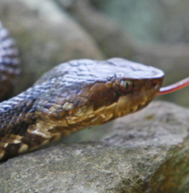
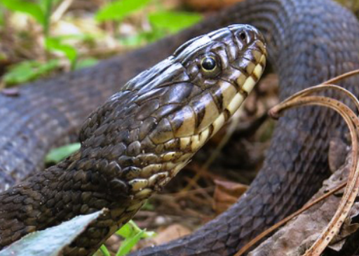
That's not exactly a good identifying feature. Most snakes that DON'T typically live around water swim with their bodies floating. And I've seen harmless watersnakes do the same. I've seen black rat snakes swim completely on the surface and completely underwater. And since cottonmouths feed on fish, they can and do swim submerged, mostly submerged, or whatever suits them. However, cottonmouths seem to have a way of swimming on the surface that is different from most other snakes. It's distinctive IF you have seen enough cottonmouths swimming and enough other snakes swimming that you can recognize the distinction. But to use it as an identifying rule if you haven't seen enough of them just won't work. Two main keys to IDing cottonmouths: the black "mask", a broad black band running from behind the eyes through the eyes to the tip of the snout, which contrasts sharply with a light colored jaw below it. And the flatness of the top of the head from the eyes to the tip of the snout, with a sharp drop off all the way around that flat top, like the edge of a shelf. Every harmless snake in MO has a rounded snout, like the end of a cigar (except for hognose snakes). Here's a cottonmouth head, showing both characteristics: And here's a common watersnake's head for contrast. Note also the vertical bars on the jaws, which are typical of watersnakes and not found on cottonmouths:
-
One thing that's refreshing is to see somebody actually correctly identify cottonmouths! Facebook (especially the Missouri Nature Lovers group) is a cesspool of people misidentifying harmless water snakes as cottonmouths (when they aren't misidentifying them as copperheads). I've had several over the years swim up to my canoe and look it over. I've had to splash them with the paddle before they'd back off. It's not that they are thinking of attacking me. I think they are just curious about that strange log floating by and want to check it out and maybe climb up on it for a bit. And they really don't much care if it's already occupied. Half the cottonmouths I've ever encountered fled from me like I was certain doom. The other half were just of the opinion that if I had a problem with them I was expected to back off and get out of their way.
-
Correct. Like I said, under stable water conditions (no big rains recently), you can figure that the Gasconade above the Osage Fork will be contributing about 60% of the flow at Hazelgreen, and the Osage Fork 40%. So if you're floating not too far above the confluence, take the flow at Hazelgreen and multiply it by 0.6 and you'll be in the ballpark of the flow where you're floating. So...150 cfs times .6 equals 90 cfs. 100 cfs is minimum for easy floating (though, Wrench will tell you and I agree that if you're fishing and willing to work at it a bit, you can have a lot of fun on flows well under 100 cfs). But if there's been rain in the area recently, it's impossible to predict just how much water one stream is contributing and how much the other is.
-
Gotta remember that the gage at Hazelgreen is below the confluence of Osage Fork and Gasconade, and you were floating well above the confluence. So if Osage Fork flows about 2/3rds the volume of the Gasconade above where they come together (which is probably about right for lower water conditions), you were floating on about 115 cfs, give or take 10 cfs.
-
Panfish Identification and Weight Estimation
Al Agnew replied to MOBass N Beer's topic in General Angling Discussion
Several of the sunfish species hybridize with green sunfish. Given the length of the gill flap, this one very well could be a longear/green hybrid rather than one of the more common bluegill/green hybrids. It's definitely a hybrid with green sunfish in it. -
Personally I only use snap swivels when I absolutely need to, and since I don't fish in-line spinners at all, and don't troll, I never have to worry about line twist. So I really can't give you much advice...but I DO use snaps (without the swivel) almost 100% of the time using hard baits, whether it be walk the dog topwaters, crankbaits, or spinnerbaits (I make of modify spinnerbaits so that they all have closed eyes; the R bends that many have to tie your line to won't work with snaps). It really doesn't matter much whether the lure already has a split ring to tie to...I usually leave the split ring on and snap directly to it. There are a bunch of reasons why I do this; for one thing, the snap helps the action on some lures (especially crankbaits and walking topwaters if they don't already have a split ring to tie to), second it makes tying the only knot I ever use, the palomar, a whole lot easier tying it to a snap instead of directly to a big treble hook lure, third I can switch lures quickly. Only drawback is that I sometimes fail to retie after several hours of heavy use.


