Devan S.
-
Posts
1,387 -
Joined
-
Last visited
-
Days Won
14
Content Type
Profiles
Forums
Blogs
Events
Articles
Video Feed
Gallery
Everything posted by Devan S.
-
Idk about the rest of you guys but i'm in reasonably good shape. When I start dragging a deer through the woods, I make enough noise to scare everything off for the entire section....I wheeze and pant enough too that I could easily mistake myself for a mad cat.
-
I'm gonna say possible but highly improbable. I've called quiet a few cats in predator hunting and they are pretty sneaky and easily spooked. Usually just the slightest movement and off they go. I will say one thing though, a bobcat in a foothold trap, may be the meanest acting animal I've ever seen.
-
I use yellow power pro for my crappie jig rods......99% of the time I straighten the hook and for long casting the sensitivity helps. Yellow hasn't washed out in 3 years of use.
-
I have.....problem is the boat lifts block the brush they hang right underneath the walk way.....I'm just not good enough to get it all the way back there. I think a 16ft. rod I could just dip em. Although maneuvering a 16 ft. rod is a nightmare. We ran across 5 slips that I could see the lines under the walk ways holding the brush but they all had empty boat lifts blocking the way....I tried to toss over them but it doesn't work as well..once we found a slip I could get into with brush we found some fish. My normal timber/brush pile run was difficult lots of trash in the way. I've found they like the bobby garland swam slower than slow and with no other action. Hard to do that in mats of trash.
-
Water is pretty stained, actually dirty maybe a foot visibility. Lots of debris blown together in mats and some large stuff. Fished between Viola and Akin back. Brought home 6 crappie and probably caught another 5 or 6 shorts. Had several short bass, all the fish were really washed out with the dirty water. Never turned on the graph to get a water temperature. I've determined that i'm just dang near worthless fishing docks. Really considering buying a 16' jig pole to try and dip jigs way back under the docks and around the boat lifts.
-

What is your bucket list fishing trips?
Devan S. replied to Devan S.'s topic in General Angling Discussion Archives
I'm marking one off my list in Jan....gonna spend a couple days in an ice sleeping in MN. -
Phil do you think you would see the same amount of downturn though if you were above the dam vs. below. Obviously even reasonable flows can turn wading fly fishermen away, moderate flood gates open can turn people uncomfortable with boating in current away but does the same downturn hold true with high water on the "lake" side of things?
-
You're the man! That is a killer deal then for minors if there is any thought they may grow up to hunt and fish!
-
The only reason I ask is back when I looked into it I didn't see a benefit for any age group unless you bought every license, every year and even then the math never really worked out it just got close with some semblance of convenience. . Where is shined was for a minor it was something like $300 for lifetime for both. Well what says they would stay and remain a resident?
-
Crappie and walleye fishing is the same way for me. If I catch one walleye, I will absolutely froth the water trying for more....most of the time, I'll pick up another.
-
Out of curiosity.....what happens if you become a non-resident after buying the lifetime tag? Do you retain your privileges?
-
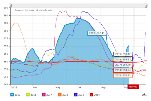
Red flat line is "normal" more or less for Bull Shoals. 6 years of data, maybe 5 times its been over 10ft high I see 3 solid summers of near normal levels. Substantial flood in 2017 that covered the entire summer. 2015 had most of the summer high.....a couple high water times in off peak. 2017/2015 were high water years for all White river lakes we're talking record events in all 3 lakes...high inflow, high outflow, high levels. Rain falls....people get pissed because it disrupts there "season". Anyone care to imagine what 200k+ CFS going through Branson or Lead Hill would look like?( I can tell you lost business doesn't remotely compare to the actual damage) The dams and their operators worked exactly like they should to reduce downstream impacts. Guess what Bull Shoals has 40ft. of flood pool for a reason....it was designed from the get-go to be the catch basin. Although I guess I'm missing 40ft. high every summer. I'm not aware either way about what gets flooded but I would assume much like Table Rock the "take" line prevents tons of flooding that would happen otherwise(mostly because people are out of touch with the realities that come with living on a lake). As for the additional knock on engineers/architects, I work with a bunch that are idiots, some of those idiots call me an idiot. I also meet cashiers, bank tellers, employees, welders, hair dressers, accountants, car salesmen, doctors, lawyers, telemarketers, management, teachers, IT workers, pastors, immigrants, police, firemen, EMT's, mechanics, dog walkers, salesmen, painters, construction all out of touch with reality on a daily basis. There's people good/bad in every profession, people that will lie, cheat, steal, twist numbers to benefit themselves in every single profession. Being out of touch with reality, stupid, and/or ignorance isn't by definition related to your day job. It's a disease that effects EVERY single person in the human populace at some point and time because nobody has all the answers. FWIW- I don't really care about water level, I'm a farmer and I like rain until its muddy, then I like sun, until its too hot, then I like cool and rain, and the cycle repeats. I primarily fish Table Rock for species that aren't the golden child of the fishing world(Bass). I would happily take 10+ft of water. It opens up a literally whole new world of crappie, walleyes, whites, and catfishing for me. In fact, I firmly believe that more water is more habitat, better recruitment, stronger population of fish, which I am all for. It does seem funny however that on the Beaver forum the complain about high water, TRL forum they complain about high water, and Bull forum complains about high water every stinkin year. Mostly by people that are merely inconvenienced by high water, compared to what it does downstream.
-
Did Dick Cheney attend? Sounds like his kinda party.
-
Auto-Pro detailing in Cassville usually has a few boats sitting outside. Probably a bit of a drive but I've heard they do a good job but have not used them myself.
-
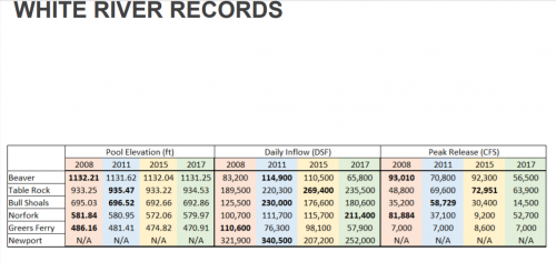
Flood control isn't about upstream of the dam.....its all about downstream of the dam. Once they pass water at Bull Shoals its no longer controlled, they regulate to a stage based that is reactive to other water coming down the Mississippi to prevent downstream flooding. All the peak inflow records are 2008 to present but its probably not more weather/flood events is probably mis-management. More water in = more water out or higher levels. BTW I'm sure you would say this data is made up anyways. I get it y'all need something to complain about and facts and data can't get in the way of that. Irregardless what anyone thinks, the Corps laid out exactly how they intend to release or hold water in the slides. Read it you might learn something. If you don't like it then break your piggy bank open and throw your money at it. You literally cannot expect to live on or near the water and not expect high water and floods to happen. Its like buying a pig farm and complaining it smells like pig crap.
-
Devil's cut......mmmmmhmmmm.
-
We don't put much stock into anything they do or tell you yet we use stuff built, designed, and manufactured by them everyday. Don't worry I get it your not a facts and data guy. Shoot, ready, aim right? I'm well aware Johnny has interest in Table Rock Lake but the lake level being 915 or 930 doesn't matter to him. Life goes on at Big Cedar, Dogwood, Top of the Rock, and Bass Pro regardless of lake level.
-
I'm not trying to play both sides or stirring. I think its a fairly complex problem, that covers a fairly large area of land, that is extremely reactive to conditions that most don't think about. Add in downstream effects and the magnitudes jump more than 10 fold. All the data is out there including historical: -Peak stream flows -Mean stream flows -Lake levels -Generation/dam releases -Personal weather stations all over the place that record everything you could need You can theorize that Johnny Morris is paying someone to keep Table Rock prime for tournaments but he has bigger fish to fry. The guy make far more money selling T-shirts, hats, and junk out of his store than he would by keeping Table Rock at prime level. It just doesn't matter to him. The only people a flood hurts is Ma and Pa shops and even then I side with @snagged in outlet 3 The people lining pockets for these decisions are influenced by big AG/insurance companies and the results of downstream flooding. Nothing more, nothing less. FWIW a personal gauge in Protem did record 3" of rain on October 6th but it was relatively slow steady rain that came on the heels of a month of September with highs in the 90's and minimal rainfall. Based on that I would theorize your 10" of rain that fell in NW Arkansas(not all of which actually fell in the white river basin) was mostly held back by Beaver/TRL which both showed a rise and to the east where less rain fell, at a slower rate, it mostly soaked in. Shortly after that they begin lowering Table Rock(which by the way has much bigger inflow potential compared to Beaver) and then another rain happened. All the while, the only way Bull can release short of a true historical flood, is for the downstream gauges to allow them. The corps handed out their guidelines which is pretty bold of them with the number of morning after engineers now a days.
-
https://www.accuweather.com/en/weather-news/flood-damage-and-economic-loss-in-the-heartland-to-reach-125-billion-this-spring/70007899 12.5 BILLION I hate to burst your bubble but its not Johnny you have to outbid.
-
Is there an optimal tournament water level?
-
Well sure if you use localize rainfall amounts over the entire basin but you know it didn't rain a solid 10" from Rogers to Springfield to Mountain Home and circle back through Kingston Phil showed where the bulk of the rain fell in NW Arkansas during that storm.
-
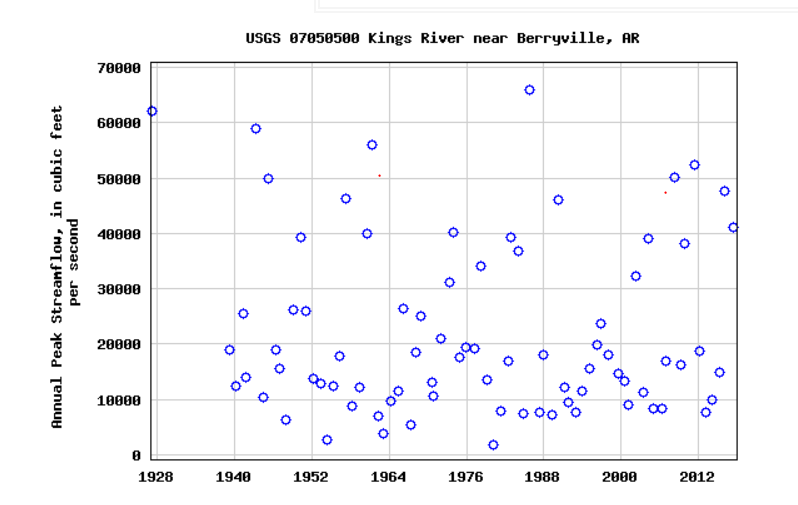
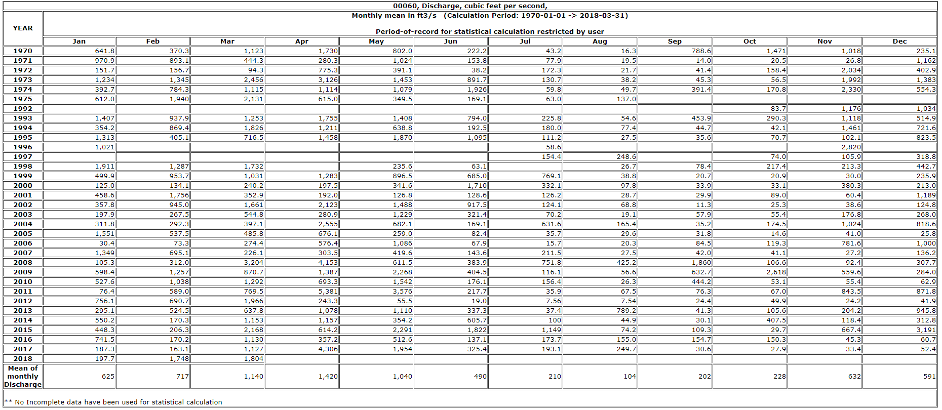
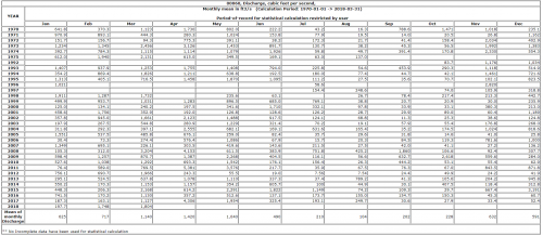
So the cool thing is......someone with some free time on their hands could in theory mine this data using the USGS water data(I bet the corps actually has this data). For example on the Kings river(which is a large inflow to table rock) and starts within spitting distance from the white which is Beaver's big inflow. You can easily find Annual peak stream flow. In addition they will give you monthly mean discharge(sorry for the small copy/paste) So you could easily mine the data to make the case that either: A. there have been more floods in the last 10 years. B. there haven't been more floods in the last 10 years. I would bet they have the same statistics for the James river too which could add an additional data point and even further prove or disprove the theory. In addition, someone could probably pull the daily lake level along with the daily inflows and ACTUALLY tell us how bad of a job the corps does at actually managing.


-
It actually does compute......look at the aforementioned slides. They clearly give you the outline of how and when. Slide 32 clearly states 6.6" average runoff volume for the upstream area so a 8ft rise isn't out of the question for a 2" rain at all.
-
I agree.....I also feel the same way for the people constantly complaining about the high water on the lakes. Specifically when for 99.9% of those people its only an inconvenience to recreation.
-
Real floods, as in uncontrolled releases of large volumes of water, kill people, livestock/produce, tear up infrastructure, impede commerce, and destroy personal property. Ask people along the Missouri/Mississippi how they feel about real floods going away. Most of them will tell you the same thing it seems like its always high water and for most of them this year it has been high water just as long or longer than any of the white river lakes. High lakes for most just cause a slight inconvenience and generally only to recreation uses.