Feathers and Fins
-
Posts
5,907 -
Joined
-
Last visited
-
Days Won
2
Content Type
Profiles
Forums
Blogs
Events
Articles
Video Feed
Gallery
Everything posted by Feathers and Fins
-
On a Lake I find the nearest dock and get in it till the storm passes, really no reason with all the tech today to not have good warning time to hide on a lake. River or creek I find a Bluff and get out of the boat and on the bank under the bluff-line to stay the lowest point. But truth be told If bad weather is forecast I wouldn't be on a river or creek period its asking for trouble if flash flooding happens.
-
Mizzou Stuns Georgia, But At A Cost
Feathers and Fins replied to ozark trout fisher's topic in Sports
SC is beatable you have to take their run out of it, if that can be done I see a Win. Florida can beat you so many ways offense and defense that is the true powerhouse to worry about. Ole Miss is a possible win, Kentucky should be a win, Tenn better be a win. The Johnny Football show? Well pray he is injured or its a loss. ATM with him is insane I give that kid credit he really makes the game fun and his team is having fun that is a dangerous combination. Mizz can have a 9-3 season easy maybe even 10-2 But must beat Florida or ATM for the 10-2. If they beat FL then they should be # 4 or 5. -
Ya that would be a pucker factor of 10.
-
Mizzou Stuns Georgia, But At A Cost
Feathers and Fins replied to ozark trout fisher's topic in Sports
12 to 15 they need 2 more SEC wins to crack the top 10. Georgia was not the same as it had been prior to injuries so the pollsters will look at that. Yes its wrong 100% as they are unbeaten and should be placed with the other unbeaten first then strength of schedule second. -
Tough day with the East wind Jason you didn't miss much, I caught some legal crappie and a ton of short walleye, Oh and the traditional ( btw getting a little ridiculous )gluttonous perch.
-
Federation tourney I believe.
-
The answer is simple these things. A picture is worth a thousand words. This fish ate a flicker shad and had this in its mouth when I reeled it in.
-
The best advice I could give you is Search the site for RPS post, Quillback post, and Bill Bablers post. Those three guys post will give you more than enough reading material on the lake with RPS and Quillback heavily fishing the upper end. For my own perspective, I love the upper end but I target mostly the White River Arm for Walleye and the rare Striper. It is a very quiet area from November to about May 1st and beautiful. Also is always the possibility of catching some nice trout and bass.
-
Fellows Lake Muskies
Feathers and Fins replied to pruett417's topic in Fellows Lake, Springfield Lake, McDaniels Lake
I hear the same argument about Striped Bass all the time and yet every ounce of evidence shows they are not the " eat everything out of a lake machines " the claimers say they are. I do not know as I have stated the Biology of a Musky but it would seem to me they are just another fish and probably are not killing all the fish in a lake, that would take an ungodly sized population of them to destroy a lakes biomass. I would tend to lean toward over harvest by fishermen of the more preferred eating species as the most likely suspect. Handling Musky granted can be a issue by anglers but unless you continue to try to inform the novice angler it will not change, MDC and Marina officials should attempt to do more if possible even if its just in signage or a brochure to be handed out when entering the area. Florida has gone to great lengths to protect Tarpon and my suspicions based on what I do know about Musky is they are fragile just like Tarpon and it would seem prudent by MDC to possibly follow suit with Florida in how they care for hooked/landed Tarpon. 1. require a Musky Tag if you wish to keep one ( I base this off from my understanding few people keep them but some may want to so for those who wish to keep one require a tag ) this tag money could be directly used to help fund stocking programs in musky lakes for them or baitfish. If they did it in the form of a stamp many anglers may purchase it just as a nice keep sake and still be aiding in conservation. Think of it Much like the Federal Duck Stamp where many buy it simply as a conservation tool. 2. Require no Musky ( excluding those to be kept ) be raised out of the water. ( I know some will argue you have to because of their teeth ) I say horse manure to that I have caught and released countless sharks without ever taking them out of the water. There are tools designed to remove hooks from a safe distance. Having so few lakes in the State with them is a true Unique Opportunity and special resource and should be managed and treated as such. From an outsiders perspective I just have to smile and wish AGFC would give us this unique opportunity, you are lucky to have them and they need special treatment as they are a special fish to have in these southern waters. -
so very true but one step further, You can even look at the direction for wind and shade eleminating even more bad areas for productive areas in the same conditions.
-
Really, coming from the guy who was drooling over the maps I sent him lol.
-
DO IT MARTY, And Duane Jammi says THANK YOU as well.
-
Probably be around opener of middle zone before I get up there.
-
JD I have done it with Deer and its great, honestly hadn't thought about it for goose till now... But im betting its great
-
Yup, that's it basically, the Navionics maps are great as for the most part the lines stay solid so you can use the paint can pretty easy. If you don't have it here it is http://www.navionics.com/en/webapp Then transfer it after you use Adobe to Excel for the insert pictures. save as pdf and then reopen in the adobe and save as a jpg.
-
This is payback for something isn't it Marty. Dam that looks good
-
Man I feel your pain about TR its a hard one to color even with Navionics and all the tools. contour lines way to close.
-
Yup 5'' gizzard shad
-
Ok is was 3:18 but I have a legitimate excuse I got in a great bass bite first He started it and made me have to pull out a Jig, Stopped the boat and cast a flicker at the bush he came off of and this dang thing ate it before I even started to retrieve it was a surface hit. Then I pulled out a Keitech and started jigging the bottom at the tree for a few more walleye and some more bass. But I did eventually decide to play with crappie.
-
Crappie = 2.1 to 2.5, I went again today and tore them up again. Even had to pull a jig out ( found some nice bass that wanted to play ) Surface bite was just starting when I left lots of shad around and lots of things making dinner of them.
-
As a matter of fact I just finished a few maps last night so I need to go check them today. Think I eat my lunch finish paperwork and then go check them. Any bets I have crappie by 3pm
-
lol, I think most fishermen are to lazy to go in to this much detail they want their waypoints and sonar and are happy. I am very detail orientated I want to know what it is why it is when it is blah blah blah. Besides making your own maps to me is fun. First you have to go FISHING to start so its a "reason" then you got to make the map and then go FISHING to check its accuracy so there is another "reason" to go fishing lol. See it all priorities
-
Sounds like my favorite stunt to pull on people in the duck blind, When they are out collecting birds Unload their gun and reload it with confetti rounds. Pure Priceless when the next group swings in.
-
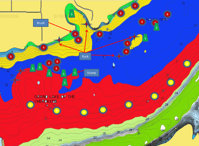
I should note, THOSE ARE EXAMPLES and not a true map, Also where each is labeled I will have the exact depth of the structure at lake height I did it so I can quickly know based on current lake height how deep the structure is. I made this fast as an example only.
-
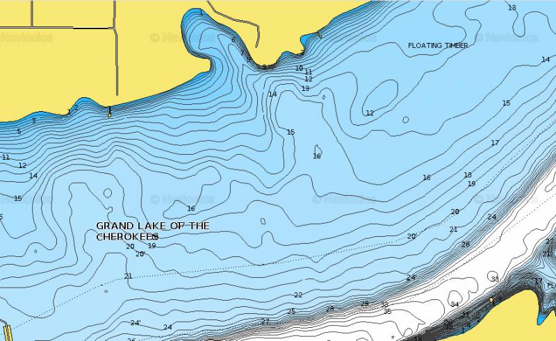
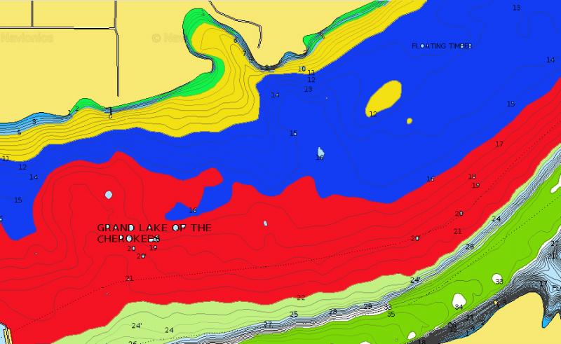
I have been updating my maps the last few weeks and thought it might be helpful to others to see how I do it and the process for making lake maps tailored to an individuals needs. First in the process is to take the boat out to the lake and sonar and area, I do it with both side scann and down imaging though it can be done with down imaging. Using your lake map with down imaging I snap a picture on my phone of sonar with the Map and down imaging on so I know what type of cover it is and where. When in doubt I will drop the Aquavu to verify. After I have covered an area thoroughly I go home and pull up Navionics website and do a print screen capture of the specific area. I take the print screen and put it on my “Adobe PSE Editor” and color in the depth contours of the lake ( 5 ft to 10 ft intervals ) depending on how the navionics loads. After that I will open Microsoft Excel and import the image to it so I can use the insert drawing image for shapes to identify specific structure types and then using boxes label the type and depth of structure. Many of us have waypoints marked on our units but never see the big picture. Using the excel I can create page breaks and off to the side place the picture with an arrow to mark on the map along with knowing exact depth and orientation of structure. This enables me to see the big picture for a large area and when you build it starts ingraining in your head what an areas big picture is. When you are complete you will see that picture and understand the area much better. For me It enables me to set-up a troll pattern to quickly verify with the down imaging what type of structure holds fish and if they are biting. I can then eliminate rock vs brush or transition banks vs pea gravel in very quick order. Within a short amount of time I know the fish are on Brush but not rock and I know they are holding on Brush off pea gravel but not Brush off Slab Rock. More to the point it tells me what species is there so I know how to proceed. After the elimination passes are complete I can continue trolling or go back and work an area with crappie jigs or football jigs or cranks etc. This allows for putting more fish on the hook and less time scratching my head. Here is how the maps work. Take the Screen shot Color the Depth Lines using Adobe Open Excel and import the picture using 1 page landscape. Then start inserting the structure icons of your choice Save as a PDF and open Adobe back up to save as a picture (jpg) Typically this takes me 2 hours but on a very detailed / heavily structured area it can take more time. Now you have a detailed picture of the area and can pick it apart much faster.