


navery
-
Posts
297 -
Joined
-
Last visited
Content Type
Profiles
Forums
Blogs
Events
Articles
Video Feed
Gallery
Everything posted by navery
-
I know for a fact that there are 36" plus musky swimming in McDaniel lake which is between Fellows and Stockton. Saw one on a stringer last year and saw one surface 4 foot in front of me 2 weeks ago while catching bait from the bridge. Very possible with the past flooding for them to make it to Stockton. IMO
-
Longest copperhead on record that I can find was is Texas and was 53"long. They have another unconfirmed one out of Louisiana that was 54". This, at least, could've been a state record if not potential world record if your estimates are correct. What a beast!
-
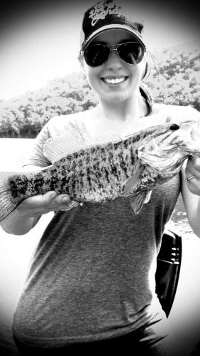
I'm not a big bass fisherman, but I would call that a smallmouth. I attached a pic of a smallmouth that my wife caught below powersite a few years ago. Only could find a black and white version, but it still shows the markings.
-
They showed up around 7 pm at the dam as I was leaving. I caught a fat 26" male walleye before they arrived and saw them dip net several nice fish as I was idling back to the ramp. The walleye are definitely there in numbers right now.
-
- 2
-

-
Truman Tailwater Generation
navery replied to Linhardt's topic in Truman Tailwater/Upper Osage River
Well it's crowded, but walleye and whites with a few hybrids are being caught. Walleye are in full swing. An 11 lb plus 31"was caught Friday -
How did someone launch a bass boat at 160? There's not even a ramp there or turning around room?
-
Truman Tailwater Generation
navery replied to Linhardt's topic in Truman Tailwater/Upper Osage River
As you can see they have been running everyday since 2.21.18 and some days multiple times -
Truman Tailwater Generation
navery replied to Linhardt's topic in Truman Tailwater/Upper Osage River
I go to following usgs site and check the gauge height. It is updated every hour. If you see a spike in level, you know they turned it on and its running. That being said, they can and do stray from the schedule. Best thing to do is call to see when they are planning to generate and check the gauge for a spike confirming it. If the gauge history shows regularity or that they have been running for consecutive days, there's a good chance of them sticking to that pattern ish. It still comes down to, they turn it on when they decide to. https://waterdata.usgs.gov/mo/nwis/uv/?site_no=06922500&PARAmeter_cd=00065,00060 -
I will buy some of you tell me where the bottom picture was at. I recognize the other two pics, but not the last one.
-
Thanks for the info guys. I will try Beaver. I was able to launch my deep v at shadow rock a couple of weeks ago but had to wear knee high muck boots to do it.
-
Does anyone know if shadow rock or k dock are usable? By the gauge, it looks like they have been running water pretty regularly so I would think it would be open, but would appreciate info before dragging the boat 1.5 hours. Thanks in advance
-
Is not an ultrex, but I upgraded from a Terrova to the ulterra and it is substantially better. It does have the external GPS puck. I was having similar issues as you guys with my old Terrova. It would hold on an area rather than a 6ft spot.
-
It was still under water 2 weeks ago.
-
Brand new, came on my new Targa. Had tracker put an ulterra on it day 1 and have this leftover. 24 volt, 70 lb thrust, 60"shaft. $700 SOLD
-
Thanks for the info! I am gong to try it this week.
-
I was able to launch last week in swan and skirt around the bridge but am worried that it will be to shallow now. From what I see on the gauge, it looks like the lake dropped 2 ft from last week? Any suggestions? Is beaver useable?
-
Nice pics! I fish the pothole also. Never know what you are going to catch down there. Where did you guys launch from with the high water?
-
I've heard of a few small stripers being caught also, but people tend to be hush hush about it.
-
-
Mine were wired by the dealer at time of sale when they installed the bank charger so I never really looked how they are wired. Mine are located up in the front deck just in front of the windshield. There is not a bunch of extra room with the second battery, but they fit fine? They are great boats. I have caught a ton of fish out of this one, but need more room for the family now that my girls are getting big enough to go with. When I get this one sold I will probably get one of the Targa V20's.
-
Truman is so big it is hard to answer your questions accurately. What direction are you coming from. What are you fishing for. Are you just wanting to pleasure boat. It has so many different areas. Your boat will be fine on most of them barring any really windy days and depending on your boating knowledge.
-
How high is the water now? Are any ramps usable now?
-
They should be for awhile. From what I hear its the same as it has been for the last three weeks or more. Tons of eater size blue cats, some nice flathead being caught on spoons from the west side and hybrids in the foam from the bank on the east side. Crappie off the docks in the dead channel.
-
You guys should head south and hand feed the tarpon at 7 mile bridge. It's a blast. If your resort is on the Atlantic side, you can catch sharks from the bank at night. You just need to use a steel leader and fresh cut bait and preferably 40 lb test or bigger. I have caught many while staying at the Islander resort there in Islamorada. Biggest was a7 ft Lemon shark. I just used some kingfish from our offshore trip earlier in the day. Or just use shrimp to catch some fish of a pier, cut them in half and throw them as far out as you can. Bloodier, the better. Post pics of you catch one! Also the stone crab claws from the fish market there are the best!
-
http://springfield.craigslist.org/boa/6141705368.html Selling because I'm am needing to upgrade to a bigger boat for the family. Thanks SOLD
