


GloryDaze
-
Posts
466 -
Joined
-
Last visited
Content Type
Profiles
Forums
Blogs
Events
Articles
Video Feed
Gallery
Everything posted by GloryDaze
-
Spent about 3 hours paddling up from Blue Ridge road this afternoon. Only made it up about .5 mile or so. Caught 6 greenies with the largest on my first cast at 14" Saw plenty of Carp and Gar along the way. The creek is really low, but still some holes to be fished. If anyone in the KC area wants to brave the paddling and dragging upstream to explore and fish this weekend let me know. Thinking about trying again tomorrow or Sunday.
-
Oops wrong forum.... check "other Ozark waters"
-
Spent about 3 hours paddling up from Blue Ridge road this afternoon. Only made it up about .5 mile or so. Caught 6 greenies with the largest on my first cast at 14" Saw plenty of Carp and Gar along the way. The creek is really low, but still some holes to be fished. If anyone in the KC area wants to brave the paddling and dragging upstream to explore and fish this weekend let me know. Thinking about trying again tomorrow or Sunday.
-
In the interest of full disclosure, the hardest part was deciding "what is high enough" to have as a retreat area. We didn't feel like trekking 20' up a bank but knew having no height was a bad idea. We ended up on a gravel bar that was probably 3' above normal rivers level. But there was an immediate bank behind us that was probably another 6' high. In theory, that gave us a Max rise of 9-10' before we were climbing trees. Not knowing how high the river could rise could have easily put us in a bind. The biggest fear we had was getting another 2-4" of rain the second night. If that happened there was a good chance we were climbing the trees. I guess in all reality the decision was made based off experience on the river, understanding rivers flood habits and a good old fashioned educated guess. We also learned just how easy it would be for a casual floater to not take their escape plan into consideration. They could easily be amazed at the view of the big bluff next to them, which of course is a death zone. Etc, etc..... That's scary about the boat around Mt Hershey. Hard to imagine what folks like that are thinking.
-
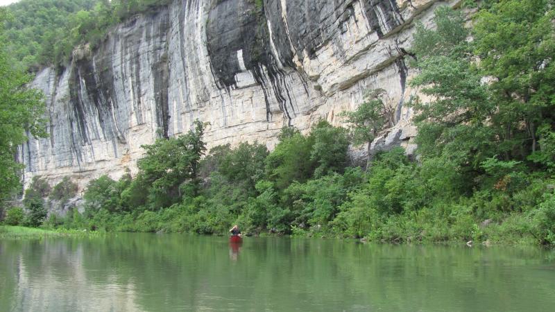
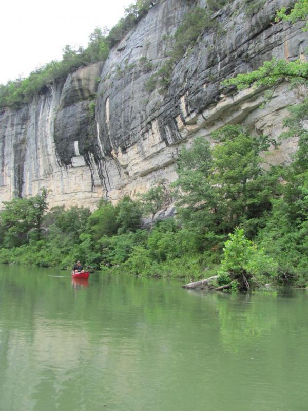
darn, great pics of Ponca we were wondering what the Bridge looked like! If you look a little closer, in pic 2 there's a huge tree that got wedged in the trees on the left side of the picture on the opposite side of the river. It wasn't there in the first pic.
-
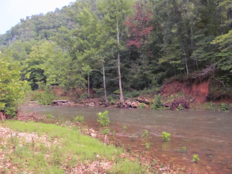
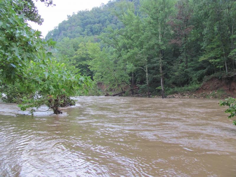
With all the rivers in MO being flooded last weekend, me and my buddy took an unexpected trip down to the Buffalo. What a pleasant surprise it was for the upper section to receive 2" of rain the day before and afford us the opportunity to float from the Ponca low water bridge in August. When we arrived at the Buffalo Outdoor Center on Friday, the place was hopping with may out of towners taking advantage of this unique mid-summer event. We were told this was the first time in 40 years the upper section had enough water in the month of August for BOC to put canoes on the river in Ponca. With hopes high, sunny skies and about 14" of airspace at the bridge we began our 2 night three day journey to Pruitt. The water was stained a little bt the fishing was excellent. Nothing big was caught, but we definitely caught plenty throughout the day. The plan was to camp just below Hemmed in Hollow and just above Kyle's landing leaving about 13 or so milel to float Saturday and Sunday. We settled in to camp had a great dinner and off to sleep we went. It started raining around 11:30pm and, quite frankly stromed like a SOB until about 8am the next morning. Now before we left the BOC we saw a forecast for 30% chance of showers, so we took precaution when we picked a camp site by strategically picking one with enough high ground should we need it. Throughout the night we checked the river and it was surely rising but nothing to panic about. When we woke up in the morning around 6, it was still storming and the river was still rising and looked pretty fast. At that point we had to make a decision.... pack all of our stuff up in the pouring rain and rush to get on the river that had risen to a level that we weren't sure was safe and head for Kyle's landing OR ride it out and wait for the unknown. We chose the option of riding it out....... First time in my life have a wittnessed the entire cycle of an Ozark river flash flood from a river bank. The water was rising about 1.5" per 10 minutes at first, but by the time it was at it's peak rise was almost too fast for us to measure. There was a whole long drawn out process that took place over the next 24 hours, but mostly it was sitting back and admiring the sheer power of that river. I just couldn't believe the size of the trees that were being pushed down the stream.. it was interesting to see how as the water rose, the size of debris grew and grew. The river finally crested at 2pm and we almost celebrated like we just won the lottery. About that time we see a dude on a big whitewater raft come flying by us.... clearly this guy had been waiting 40 years to float at this level in August, or he was bat-dung crazy....either way it was interesting. As we watched the water start it's way back down, we started the typical self- evalution: should we have left for Kyle's, did we pick ground high enough, did we tell our wives where we were going, and went through a laundry list of things we may have done differently had we "ONLY KNOWN". As we started to get the gravel bar back, we kept watching the swiftly flowing muddy water and my buddy yells 'hey that stump looks like a wolf head" joking of course.... as I stared at it, I realized it was a big ol hog out there being washed down the stream. He swam as hard as he could and made it across the river directly from us. Got out of the water shook himself off and was on his merry way. We then spent the night at the exact same location as nigh one wondering if more rain was on the way and what time we may be able to leave in the morning. We managed to miss the rain and decided that after 37 hours of sitting in the same place to put on the river first thing in the morning and head for Kyle's landing. The water was high and moving pretty fast, but wasn;t what I would consider dangerous. When we got to Kyles the little "pole" they have in the water to gauge danger levels was just below red and into the yellow. Anyway, we had to be creative on getting to our cars since they were at Pruitt, but managed to figure it out. We did learn they had to do a rescue on the River at Steele Creek with some hikers who apparently got trapped. We also learned there was a 60% chance of rain the evening before and we somehow got lucky and the front moved out. darn, if that would have happened, I may just now be getting home. Either way, it was a memorable experience that made me appreciate the beauty and danger that comes along with the hobby I love. It made me appreciate the knowledge me and my friend had accumulated over the years on how to take care of ourselves. It would have been neat for us to record our conversations as we strategically discussed the next steps.... if the water gets here, we do this.... if we lose our canoes, we do this... really a pretty amazing expereience with a good friend on a beautiful river in August. Overall, I think the gauge at Ponca captured 2-3" of rain and a 10-12' rise in the river. Where we were, it seemed like the river rose about 5-6' and crested at 2pm.
-
Sweet!!
-
Agreed...
-
Harris 122- Mark Cuban stars on a show called Shark Tank. It's a show where inventors try to convince a few millionaire's to invest in their product. That would be my guess on the correlation between the two.
-
Look it up, pretty interesting.....
-

Newbie Questions On Floating The Jack's Fork
GloryDaze replied to scklopf's topic in Jack's Fork River
Your questions about distance are personal preferance, so let me try and tackle the easy "Yes" or "No" questions best I can: I bring my own water, simply bring gallon jugs, one for each day. You could filter if you choose, but with a canoe you will have plenty of room for a few gallons of water. Most people camp on gravel bars along the river. As long as you are camping below the high water mark on that gravel bar you are considered to be on public land. However, discretion is important when making that decision. I wouldn't recommend setting up camp in sight of a cabin or a house or an obviously traveled road. Not that you are doing anything illegal, but to try and avoid any conflict if there is any. You shouldn't encounter any problems as long as you follow those basic rules. Yes you can build a fire when you are on the gravel bar, once again common sense on keeping it safe. However, be very careful that when you are gathering that wood, you stay below the high water mark or you would be trespassing. Last year there was a ban on fires for most of the summer, but not yet this year. ** I should mention, if you are floating the Jack's Fork, the land on both sides of the river from Buck Hollow to about Eminence is owned by the National Park Service. So you wouldn't need to worry about the private property issue while camping on the river** Here's a link to view a map: http://mdc.mo.gov/landwater-care/stream-and-watershed-management/missouri-watersheds/jacks-fork-river/land-use/figure-5 ** The Current has less public land. As far as outfitters, I've always had good luck with Harvey's and they are right next to Alley Spring. The mileage is dependant on many factors...... If I were to go on a 2 night 3 day trip, in order to enjoy the scenery and do some fishing, I personally would not do more than 8 miles in a day. An easy way to time it is figure 1 mile per hour if you are fishing, exploring heavily, etc.... figure 2-3 MPH if you are just paddling and not stopping much at all. One last thing- if you go in August on the weekend, be prepared for a river full of people and canoes, no matter if you do the Current or the Jacks Fork. Hope this helps a little.... I'm sure others will jump in and share their thoughts and opin -
Pretty sure it's Howard's Ford around 21.8. Not sure on the CFS...... the guide I normally us is anything less than 100 is pretty low. Try calling the campground they should give you a good update.
-
Not sure about now, but first and last time I did the upper stretch it was a mess. Shallow, portaging, etc..... every .5 mile or so. It honestly sucked. Next 2 times, put in at the campground, think it's called "Cedar Grove" and floated to Fiery Fork Conservation area. Definitely a better float with more water and less portaging. I think there were 2 bridges that needed portaging, but overall not too bad. Hope this helps....
-
Hoosier? Someone care to explain.....
-
The schedule we have had most success with to avoid crowds is: Put in at Barclay around 5 Friday night then paddle at a decent pace through all the campgrounds. Then we usually camp a mile or 2 below the old bridge piers, or just belowProsperine. This gets us into the good smallie water that night, then all day Saturday. Usually break camp Saturday around 9 and spend the day fishing pretty heavily. We usually only see a few people all day. This weekend we saw 2 rafts and a group on tubes taking out at a private access. Night #2 we usually set up camp around 6 or so and try to stay about 2-3 miles above Lead Mine. We try to set up camp before we get to a property owner's land that he is sure to let you know it's private on river left. He only used about 30 signs, had to go through 10 gallons of purple paint and has darn near every other tree marked. I know we could camp on the gravel bar legally, but prefer to not even mess with it. So, his strategy pays off at least for our group. Sunday we break camp about 7:30 or so and are usually at Lead Mine in time to be on the road back to KC by 10. It's as system that works well for us.... gives us plenty of time to fish, swim, etc... yet never feel like we are in a hurry. I'm guessing by our schedule we are well below where most float trips take place when we are on the water. Enjoy the weekend!
-
Just got back from floating Barclay to Lead Mine. I cant believe this was my first time on the water in 7 months. My last 3 trips were cancelled due to snow and rain. Weather and water were perfect. Never had a problem catching fish and they were caught from pretty much any lure. Largest of the weekend was right at 17" or so. Caught on a grub late in the afternoon. River didn't seem too busy, it also helps we have figured out our float schedule and times to pretty much avoid the crowds. Another great weekend on the river with great food, friends and fish.
-
What about a good old fashioned "o" ring. That's what I've used for years and never had a problem?
-
Ollie- is that where the old Craig O'Lee bridge was, hard to tell from the angle of the picture?
-
Yeah, I'd say you got the paddle backwards. The curve on the blades should be bending toward you when you paddle. But, on a positive note you should be able to haul butt should you want to go backwards!
-
2.0 low end 3.5 high end, take out at bay creek.
-
Way to go Leonard! I celebrated my 5 year on March 10 after 13 years of smoking. That first year is the hardest as it seems everything causes you to want a cigarette... just ate dinner, I need a smoke...... just had a beer, gotta have a smoke..... can't possibly drive without a cigarette..... tough call from boss, fix it with a smoke..... Its really nice when you can go a full day without having a cigarette on your mind. I bet after a year your already there, so Congrats!
-
Last summer when we put in at Barclay, I was talking to one of the young guys who was throwing canoes for one of the outfitters. He told me they target catfish all the way down to Leadmine and have alot of success. He told me they use trot lines at night and had luck with them as well. Not sure if it would be worth targeting or not as I just don't know enough about that section.
-
So I'm itching to get on the water. Our proximity to good streams here in KC has kept me from an Ozark trip for almost 3 months. I know there's a few guys here that could join me, any interest in planning a quick trip by ear here in the next few weeks if weather and water allow? We could put in on the upper stretch and do a quick 5 miler down to the MDC access? Wouldn't have to be a big organized trip, rather a "lets meet in Martin City for a beer and then get the boats wet?" If anyone's interested, let me know and we can try to make it work.
-
Heritage Featherlite Or Ascend A10
GloryDaze replied to Daveinozark's topic in General Angling Discussion
I can fit a 9.5 swifty in my H3, so I bet you could squeeze it in your truck. -
Heritage Featherlite Or Ascend A10
GloryDaze replied to Daveinozark's topic in General Angling Discussion
If your two requirements are fitting in your truck and able to take some wear and tear, I would definitely pick the one that fits in your truck.


