


Bluff-Bassin
-
Posts
207 -
Joined
-
Last visited
Content Type
Profiles
Forums
Blogs
Events
Articles
Video Feed
Gallery
Everything posted by Bluff-Bassin
-

Hunt Fish Swap Expo Springfield Mo
Bluff-Bassin replied to Bluff-Bassin's topic in General Angling Discussion
Wow I really figured at least one person on here had been before. -
Anyone who wants to plant brush on bull shoals LEGALLY right now can get a permit from the mountain home office. Drag your wife along if you want double the permits!
-
http://www.thearcoftheozarks.org/pages/hunt_fish_outdoor_show Saw its coming up in a few weeks thinking about making the drive up for it. Anyone been to previous ones? Just trying to see if it's worth driving a couple hours.
-
I was shocked to pull up a decent size stick today around turkey creek with NO. MUSSELS on it. That's a rarity these days.
-
Nice!
-
Looking To Buy: Old Bull Shoals Topo Map
Bluff-Bassin replied to Bluff-Bassin's topic in Buy - Sell - Trade
if not, tell them to send me an PM, I bought extras! -
Looking To Buy: Old Bull Shoals Topo Map
Bluff-Bassin replied to Bluff-Bassin's topic in Buy - Sell - Trade
Just a quick update. I was able to find the maps at a tackle shop for a 10 bucks. Thanks again for the help and suggestions! -
Looking To Buy: Old Bull Shoals Topo Map
Bluff-Bassin replied to Bluff-Bassin's topic in Buy - Sell - Trade
Wow, neat that you have the whole set, but definitely out of my price range then. I was figuring about 20 bucks a piece max. Sounds like that may be more the way to go then. -
Looking To Buy: Old Bull Shoals Topo Map
Bluff-Bassin replied to Bluff-Bassin's topic in Buy - Sell - Trade
Thanks for the tips fellas. We're actually wanting a couple of these for a home decor project. That's why we're wanting the old maps. I'm going to edit my post to we're looking for ANY old maps of bull shoals. -
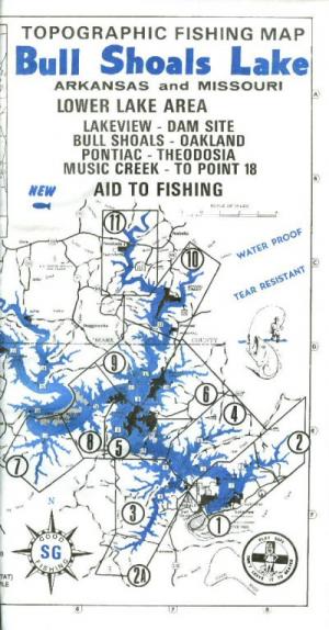
Im interested in ANY old maps of the lake. Specifically I'm looking to buy 2 copies of the older version topo map made by Structure Graphics Co. Mainly interested in the Lower Lake map. If its been collecting dust for you for the last few years I'd be happy to take it off your hands for few bucks or what you think its worth. Heres a link to it as well http://www.missourigeologystore.com/Bull-Shoals-Lower-Fishing-Topo/ Or if anyone happens to know of a bait or tackle shop that is selling them, I'd much appreciate someone pointing me in the right direction. Thanks!
-
I fish mostly Bull Shoals but feel its applicable to post in this thread. I'm semi new to the white river chain as well. I think its easy to fall into the trap of reading posts and assuming everyone else is catching them and your not. I know alot of guys (i'm also guilty as charged) that won't post a report unless they had a decent day. We all go out and get skunked from time to time. Anyone who says they've never skunked on a public fishery ever is a liar in my opinion. Keep learning and it keeps getting easier(though rarely is a day truely "easy" to catch fish. If there is one thing I've learned, there is no substitute for time on the water.
-
Great Story!
-
Sadly, that seems about a once per trip occurrence anymore for me. If you pull up any sort of wood limbs or branches with a bait you can expect it to have a pile of mussels to go along with it.
-
Is that referring to above average recruitment the last few years? If so I'm guessing by your post it could be on the downward trend after that?
-
Not sure exactly how deep they can survive but I've free dove and found them pretty far down. They've made it most of the way to theodosia. I snagged one north of spring creek yesterday.
-
Fished with the wifey for about 4 hours. Mixed it up between grub, a-rig, and jerkbait. Only caught two LM off a small bluff point over about 25fow with the Jerkbait. Both were keepers bigger one about 3 pounds. Really had to work the bait slow. Water temps between 45-46, clarity around 15feet.
-
Wow great stringer!
-
I have both. When I bought the lakemaster 2 years ago, there were only like 3 lakes in Missouri that were "HD" lakes. If I remember right, clearwater, pomme, and truman? The HD maps on Lakemaster were more detailed than the navionics maps. However for the non HD lakes, the Navionics were far more detailed when it came to contours and offshore structure. For me personally my choice for bull shoals and table rock is definitely the navionics. As far as roadbeds and building foundations, truth be told, my favorite source is still the paper hot spot maps. I look for them on the paper map, and then pin point them with the gps and side imaging. What I did is bought one of each as I have two graphs on my boat. I just swap the two map chips between the two graphs depending on what lake i'm on. If i'm fishing pomme I'll put the lake master in the console graph, bull shoals, vis versa. Hope this helps. I know there have been long drawn out fights/arguments on the BBC Humminbird forum over this topic. Oh and another advantage of the Navionics chip, is you can download the Navionics PC app for free after purchase. It allows you to browse all of the maps from your desktop computer. Its really nice. Lakemaster also offers a similar computer program but you pay like 60 bucks for it.
-
District 2 Fisheries 2014 Fourth Quarter Newsletter
Bluff-Bassin replied to mojorig's topic in Lower Bull Shoals
Really enjoy reading these. Thanks! -
Chunk!
-
That's awesome and very inspirational! Thanks for sharing.
-
Yeah they are thick through the Oakland area all around the saddle.
-
12/19-12/20 Only 3 Fish Caught But...
Bluff-Bassin replied to Bluff-Bassin's topic in Lower Bull Shoals
As far as I know my boss doesn't check the OA forums, but in case he does, I need him to think I was actually sick! Ha jk, Just like to stay semi incognito. -
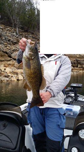
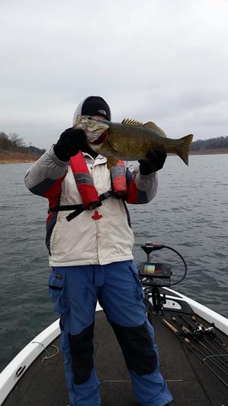
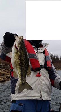
One just so happened to by my new PB Smallie. A special thanks to the gentleman in the red ranger close by who let us borrow his scale(the batteries died in mine of course!) Went 5lb4oz. Now the deets. Water temps were 51 main lake. As low as 47 in backs of the creeks. Fished for about 4 hours with a buddy of mine on friday and saturday Fished all around the mid lake area. First hour of fishing friday hooked into this one on a 5in swimbait. Around 20fow on a secondary point with big chunk rock. Took some pics and a quick weight and let her go to help fill the lake with more of her offspring. Also caught a good kentucky and keeper lm from the same area. Then nothing. Saturday we couldn't buy a bite, tried a bunch of different tactics. I think the total lack of wind really hurt.
-
Some stud crappie!


