


bfishn
-
Posts
2,109 -
Joined
-
Last visited
-
Days Won
6
Content Type
Profiles
Forums
Blogs
Events
Articles
Video Feed
Gallery
Everything posted by bfishn
-
Yup. Goodun too!
-
It's there, but only a single lane wide, so not a really big target. To find it the first time, I made N/S passes and dropped markers on the creek bed, then went E/W between the markers to find the bridge. You can see remnants of the road on the south bank at the cove, the bridge is just a bit out of line with that.
-
Excellent points! Here's a photo taken from the International Space Station to illustrate your comments; On first viewing, I amused myself by identifying cities I knew. I was stumped by the boxed area though. What the heck is that out in the middle of nowhere??? Turns out it's the gas flares at the new Bakken Field oil well complex in ND. Six years ago that area was dark. There's reportedly enough NG by-product being burned off there 24/7 to power Minneapolis and Chicago combined. No infrastructure exists to make it cost effective to pipe it away to use, so they just light it up. ND greenhouse gas emissions are up 20% as a result. But back to leaving the lights on... Criminy!
-
Sorry to boggle your mind man. At your subtle hint, I re-read the article and found the lone reference in 5 pages of rant. A 5 second copy/paste/Google led to the details; http://www.fws.gov/mountain-prairie/pressrel/09-47.html Seems it wasn't just "birds" (as you allude) electrocuted, it was 232 eagles in a 6 county area in 3 years. But I agree with your premise of fairness. No one should be above the law. Added That said, electric transmission has been around a long time, killing birds since the first domumented case on a telegraph line in 1876. There have been preventative methods available for years, and the lone example chose to ignore them. That's hardly comparable to a new industry that's still learning the ropes. If the politics were stripped from the matter and it was a simple question of how do we keep from unneccesarily killing our critters, there'd be no USNews article, no thread, and no discussion. That's the really sad part of the matter.
-
Tough choice. Both good fisheries, but hugely different, and neither are particularly forgiving to newbies. I'd probably opt for the extra hours of fishing by staying close on Lake Conway.
-
When & where has that happened?
-
Ha! Every time I try to pare it down it becomes ridiculously akin to The Jerk's famous "All I Need" rant...
-
I picked the bridge pic above for its' resemblance to the real one that's (mostly) still there (just out from the tiny cove on the south bank). Good daytime kitty spot.
-
If you go there on a certain November morning, on the anniversary of the death of a certain expatrioted Italian gondolier, and ask politely for a tour of the lagoon, you might get more than you bargained for...

-

It's Official...u.s. Coast Guard Captain Domestic Endorsement
bfishn replied to duckydoty's topic in General Chat
Congrats! Does that mean there'll be a Capt Ds sign going up in the near future? :-) -
You're welcome. In my (as yet unsuccessful) search for lake elevations, I learned we should soon have some really good maps available; http://bellavistapoa.com/newsmanager/anmviewer.asp?a=4142&print=yes
-
I'm sure no math wiz, but that comes to around $2150 if I'm not mistaken...???????
-
Jika Rig Comments And Questions
bfishn replied to rps's topic in Tips & Tricks, Boat Help and Product Review
hmmm... have you crossed any eyes with it? -
"Shoulder" punctures like in the second pic are from herons. Same for missing eyeballs. Fish like that are way too big for a heron to swallow whole, but they spear them anyway and eat the eyeballs. I lost hundreds of trout that way when I was a trout farmer, and saw it happen many times. Sometimes the fish gets away, those are the ones with punctures and a missing eyeball.
-
Small inline boards are good for shore tracking, and make less wake than a mast board too.
-
Petition Regarding Hog Farming On Big Creek/buffalo River
bfishn replied to LetsGoToTheRiver's topic in Conservation Issues
There was a pretty convincing article in yesterday's paper, written by the farm owner, that certainly expresses his own concern for the River, and the engineered safegaurds he will pay to deploy to protect it. Seems there were also meetings held at the local fire station to allow local input. IMO now, the only real question is whether to block it simply on the remote possibility that all the safegaurds could fail. If we start legislating to that extreme degree, I'm afraid we're all in trouble. -
At only six letters, global is a pretty big word, and hard to wrap your head around. Thinking local weather in any way represents global weather is like thinking the price of gas will go down in the US if we build a pipeline to move Canadian oil for destinations overseas. It takes a lot of little drops to fill a big bucket.
-
Sort of OT but... Several years ago I bought a telescopic 'glass dippin' pole at a yard sale simply because it was 2 bucks. Beaver was up in the brush that spring (and I was between boats), so I grabbed my waders and some crappie jigs and drove to Monte Ne. Was wading the edge of the brush, probing it with the long pole when a couple guys in a bass boat flew 'round the corner and shut down when they saw me with a fish on that bendy pole. The fish jumped, showing to be a nice bass. One of the guys said he'd give me $50 for my fish. I told him I couldn't sell the fish, but I'd hand him the whole mess if he gave me $50 for the pole. They motored over within reaching distance while I kept tension on the fish, and we made the trade. One guy landed & livewelled the bass, and off they went, never wetting a hook while in sight.
-
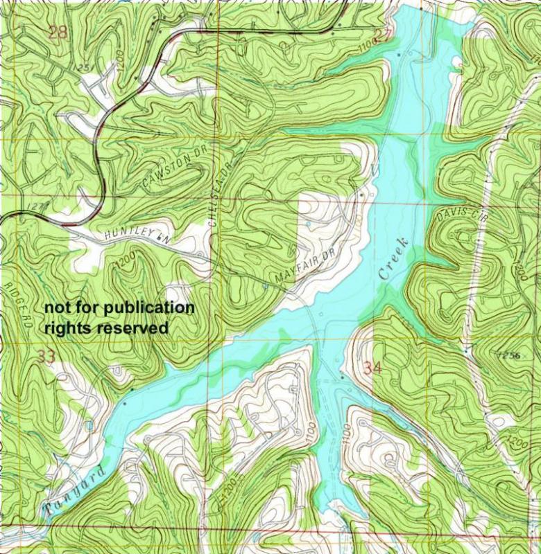
I played with Windsor a bit tonight after work. Made the water area on the new map clear and then photomerged the new & old maps using Chelsea as a snap line. Extremely surprised at the differences in the land topo lines between the two, likely the difference in photogrammatic technique changes in 40 years. Chelsea hasn't moved though, and it snapped pretty close. I reached the point of diminishing return, so I'll put this preliminary version up now in case it might help the OP on his trip. 20 ft contours. The dam shows straight down instead of contoured like reality. I'll probably delete this one when I can spend more time at it, but for now it's better than nothing.
-
You can (finally) download pre-impoundment topos (for all but Avalon) at the USGS Historical map site; http://geonames.usgs.gov/pls/topomaps/f?p=262:1:22602829645695 Select Arkansas/All scales, then type in Hiwasse (for the west side lakes). Select the oldest version ('71 or '72) and dowload the GeoPDF. Go back and do the same, only type in Bentonville North for the east side. Should be able to get the lake elevations on the POA site, but even without them a little eyeball comparison to the BV map or Google Earth and you'll have a pretty good picture of things. The house sites were all dozed/burned, and most of the timber too (pers comm). For manmade structure, the old roadbeds are about all that's left, and they're pretty subtle, but some still have a visible clue to location on the shoreline. If I ever get bored/shutin enough to redo them in Photoshop, I'll post them here for all, but I don't see that happening till at least winter... :-)
-
Is anyone seeing large schools of shad in the clearest water?
-
Ultra clear water is a thing of beauty, but it doesn't produce fish. Unless a decent bloom occurs in time (which it should), any fry that hatch in the super clear will be short-lived.
-
True, but... Zooplankton include a multitude of micro-crusteacen species, and while some are largely translucent, in the collective, large numbers of them decrease water clarity. Zooplankton feed entirely on phytoplankton, and given their various lifespans of a few hours to a few days, the entire population would crash in the absense of food. Without belittling the organizations efforts to reduce the nutrient load, or their unquestioned success in doing so, the article does give a rather poor explanation.
-
(After a tip from Sore Thumbs...) The Shiloh Museum has a nice online collection, click "next" to advance to the next picture. http://www.shilohmuseum.org/exhibits/beaver_lake_gallery.php
-
Here's a listing of the old cemetaries and where they were moved to; http://www.rootsweb.ancestry.com/~arnwags/cem/AR/benton/BeaverLake.htm I've not seen a picture, but I've graphed and caught fish (in the winter) off of the old RR trestle pier in the WR channel between Monte Ne & Pine Top. Easy to find, just sweep the channel straight out from the narrow RR cut directly across from the entrance to Monte Ne, and just south of the cut-through by HB island. Cool old story on that bridge... it was an extension from the spur that Coin Harvey ran to Monte Ne, and crossed the river to pickup lumber at Pine Top. Story goes that the bridge was so rickety that no one would ride the train across it. They stopped before crossing and the brakeman walked across the trestle. Then the engineer dropped the engine in a low forward speed and bailed off. The brakeman jumped on when the engine got across and stopped the train, and waited for the engineer to walk across.


