Devan S.
-
Posts
1,387 -
Joined
-
Last visited
-
Days Won
14
Content Type
Profiles
Forums
Blogs
Events
Articles
Video Feed
Gallery
Everything posted by Devan S.
-
Bill....I don't disagree at all...my only thing is I have a quest for a 3# crappie and the likelihood of that from Truman is a %....from Mississippi is a %+ quite a bit. Otherwise I'd bet heading to Truman....I really want to the do the wader deal and thump them too. I don't know if anyone on Truman offers that deal(of course here there is no threat of gators and limited snakes). Crazy to me....alot of good fish coming from TRL on FB...I've been in walleye mode up until the rain but it was about time to change. We shall see. There is fish to be caught here too.
-
Man were treading on thin ice here.....agree there is something wrong here but I don't think college education is going to be fixed by changing how scholarships are handed out. IIRC-something like half or better of my "top ten" in my class either aren't working in what they thought they wanted to be in(I.E. they didn't need or require a college degree) and did not finish or graduate college some if not most dropped out. Not to say they aren't good people(because they are) but they were largely the group that got scholarships compared to someone that may have had 2 times the work ethics but it didn't compute exactly to small town high school grades and/or GPA. FWIW: I was in that group(top ten) in a rural community(this is not a STLor city area high school, in fact when I got to college I realized just how far ahead an average student in the burbs was compared to me completely base on what was offered). If you have saved 150/200k for your child to live a life better then you, then I commend you. You have certainly given up luxury to further your kids in life, I also can assume with that kid of sacrifice you have instilled the work ethic to make them productive members of society . I also hope the child that got the scholarships uses them to the best of their ability to live a life that may be better than what her parents provided for her and not to party it away and drop out as a sophomore. In short life isn't fair and at the end of the day......i.e long after you are gone....things will often work out as they should. Be at peace knowing you have done what is right.
-
Man you aren't kidding. I'm seeing lots and lots of big crappie on facebook pages. I follow several guide services down in MS and they are currently tossing on their waders and in the flooded brush jigging them out. I want to just jump in the car and battle the gators and snakes and drag around a stringer full of hogs through the brush.
-
This has been beat to death hundreds of times but flood control does NOT correlate to a lake level. The corps and dam were designed to reduce DOWNSTREAM impacts not upstream lake levels. From a factual basis the dams work and continue to work as intended. The amount of water passed through the dam is considerably less than peak inflows. The problem is the user base of the upstream lakes all think "their" use is important and forgets what the actual mission was. If flood control was ever the primary or only mission then the lake would be lowered the maximum amount to accept the maximum amount of water. Meaning a constant draw down to 896(the bottom of the gates). Then constant generation to reduce it further until they reached the intake gates. Then you guys would be complaining of low water all the time(because at those levels a lot of the infrastructure becomes un-usable and we would see even larger fluctuations in water level.
-
Don't think 1 or 2- $1,000 checks are going to do much, other than increase the national debt some more. Specifically for those that are out of work longterm. Also don't think allowing anyone to take money out of retirement is going to do much either for those most affected. Considering something like half of people don't have emergency funds and a significant number have less than the $2k in a retirement account. Not a good situation anyway you spin it but something has to be done with unemployment by all accounts it looks like numbers are going to explode. Will be interesting to see after this all tames down how fast we get back to a reasonable normal. Is it going to be weeks, months, or years? Really wish I would have pulled my money but my account values are relatively low and I've got another 30-35 years to make it up. The painful part for someone who is young is looking at an account balance that is significantly lower than what you have invested over the last 4 or so years.
-
I think that is his point exactly. IF you know someone that is likely in that situation and cant get there maybe take them a casserole. The whole help your neighbor. Schools and businesses are trying to do what they can to help but there still may be some out there that are unreachable.
-
All my information is second hand at this point but I am hearing spotty reports of whites up the kings. Understand that they are not in the upper sections and are mid area to back toward the lake (Viola area).
-
Isn't that when the regulating stage at Newport goes down?
-
Glad its seven days of rain and not one big one then back dry. At the farm in Eagle Rock, its awfully dusty. The sub soil has moisture but the top couple inches is dry(sun, wind, and warm temperatures dry it out fast). Not to mention wont be long with these temperatures and the grass will start soaking it up.
-
Exactly right. The tackle/rod/reel market is heavily saturated. You have tons of options at tons of price points and there isn't a single manufacturer that needs BPS or that BPS needs to have at this point. You can buy almost anything you want with a simple keystroke. At the end of the day, almost all these manufacturers are using the same input costs via labor, nearly the same input costs for machining, and the same costs for raw materials. I bet if there was someone really in the industry at the actual manufacturing level they could tell you that from a costs standpoint there probably isn't a serious cost difference between expensive items and cheap items and the bulk of the difference is made up to cover things like overhead, sponsorship's, and corporate profits.
-
man you sure can bring some pretty fish to hand.
-
Like I said some on the TRL forum give far more than most would or should....but reports that don't go well are sometimes just as helpful. Historical data is even better, I cant count the times I've been able to research historical actions on here and go out and duplicate things years later during certain times often in different areas. @Quillback I have tried to duplicate his striper success based on historical reports. Otherwise I would just be in the dark(not that I'm much more enlightened now). Reports can often be as simple as water temps, what your tried, where you launched, what happened that day. Heck sometimes even non-target species.
-
To some degree yes. Largely though there is really only maybe 10 people on the TRL forum that actually provide reports. Maybe 3-5 that provide far more information than normal. There is certainly a lot of guys on here that fish Beaver but those guys don't report.
-
Not to mention their payment terms will likely be 90 days and they will probably not pay until 120 days but your still shipping millions of units to keep them in stock. Better have a great line of credit and good margins or be swimming in cash beforehand.
-
Need to run that boat as far up rock creek as you can. Tie on a jerk bait and start slinging it on days like this.
-
I have a couple cousins that ride trains for a living. Both can, will, and do make calls on a weekly basis for trespassing. They have and will comment on every picture posted on facebook about senior pictures, family pictures, or other taken on the railroad and have reported them. Both get incredibly wound up about the trespassing on RR private property going into the explanation about people getting killed and how it affects the engineer or conductor. I guess I don't get it. If your not smart enough to get out of the way of a 3/4 mile long, million ton train and you get hit then so be it right?
-
BTW The regulating criteria for Beaver is: Firm power until TRL and BS is within 2' of conservation pool.
-
Remember only one of 3 dams got the "emergency" spillway. You can bet they will do what they can to avoid having to use that.
-
Its totally unsubstantiated but I think the reasoning is that Beaver has the smallest drainage basin and based on historical data Beaver has to ability to pass all of its inflow short term. Meaning running right at full pool level is overall less risky. Compared to allowing Table Rock to run high. Bull Shoals is obviously last in the chain and is regulated based on downstream conditions so it will always be the catch all basin. IIRC Beaver has released on the magnitude of 90kcfs at a time and as I recall the maximum inflows were in the magnitude of 110kcfs. Table Rock is second in the list has 2 huge drainage basins north and south(meaning a storm tracking slightly north or south still puts water in the lake). Both the Kings and James can get very large inflows even if it doesn't rain a drop right over the lake itself. Inflows that historically Table Rock has not and will not pass through EXCEPT for an absolute worst case scenario. IIRC Table Rocks max historical release is something like 80kcfs or that ball park and max inflows is on the order of 250kcfs. The James river and Kings river alone based on historical maximums could be something on the magnitude of 120-130kcfs. The idea being once they let a drop of water out of Beaver dam unless they can pass it to the White downstream of BS they will not risk the huge release through TRL.
-
Even if they are marketed "Made is USA" chances are high all the components are shipped in from overseas and the bare minimum is done to them to be able to market as made in the USA.
-
I would say its less about the accomplishment. More about the experience and a token of doing it. The same way with literally any number these kids of deals.
-
There will undoubtedly be people that lie about it or use historical catches to get the bling. I don't believe there is any real verification process. I'm thinking I'm gonna give it a shot.
-
https://mdc.mo.gov/newsroom/test-your-fishing-skills-through-mdc’s-first-blue-ribbon-trout-slam Looks like MDC has partnered with trout unlimited to allow you to log/report your catches and end up with a pin and medallion depending on number of streams that you complete. I'm feeling intrigued, I've never fished any of the sections and I'm really not a trout fisherman but I am thinking about trying it out. Tell me under normal conditions, what would be the most difficult sections to complete? Barren Fork Creek in Shannon County Blue Springs Creek in Crawford County Crane Creek in Lawrence County Current River in Dent County Eleven Point River in Oregon County Little Piney Creek in Phelps County Mill Creek in Phelps County North Fork of the White River in Ozark County Spring Creek in Phelps County
-
have seen them quite a bit at Grand Lake in Oklahoma....have never seen it in Missouri.
-
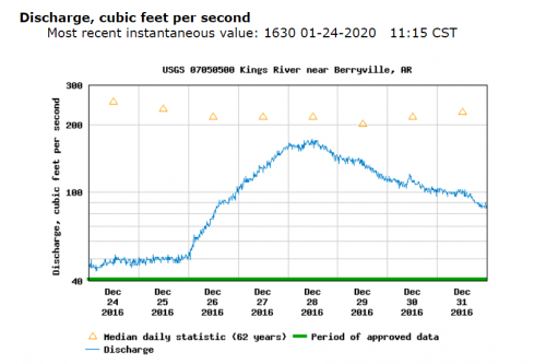
Back to the topic at hand....Here is why I use CFS but generally I am floating..not fishing so walking riffles is something I don't want to do. Kings River will never show less than 2'; the gage is in a hole under the bridge. Get down in the 2.5' range and there may be riffles that just appear wet with no visible flow over them. 50CFS I am dragging through many riffles, 100CFS I may bump a big rock 1 or 2 times in 8-10 miles when choosing a bad line. 100 CFS is smooth sailing, 50 is a soggy drunk hike. Difference in gage height? Maybe 3 inches Why? because in that bigger deep hole it takes a lot more volume in/out to raise the water level 3" than it does in the shallow riffles where you end up walking through. In reality 3" would make sense if the measurement came out of the shallowest riffles but when the gage was measuring 2.8 vs. 3.1 ft. I'm not sure I can distinguish the difference in ft. in that hole where I can in CFS.