


96 CHAMP
-
Posts
1,268 -
Joined
-
Last visited
-
Days Won
1
Content Type
Profiles
Forums
Blogs
Events
Articles
Video Feed
Gallery
Everything posted by 96 CHAMP
-
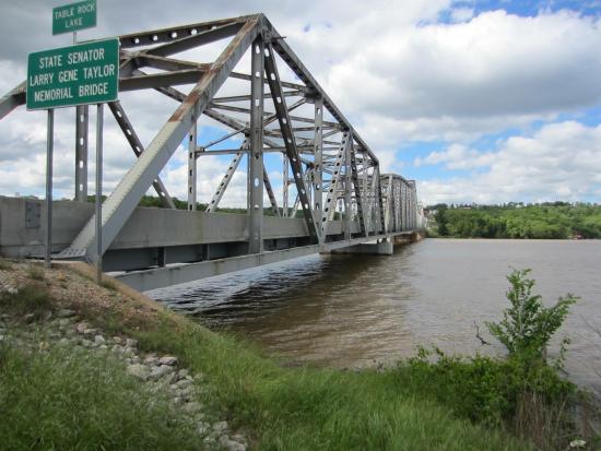
Just received this picture Shell Knob Bridge, unreal!
-
The one we used to fish was great till they started pulling gravel out of it near the low water access where we used to put a John boat in thus causing water to flow through. All the tree roots and other cover became exposed due to lowering of water level, you no what happens next. That particular hole was probably 1/2 mile long.
-
I grew up creek fishing down on my grandparents farm years back, had a lot of fun, a very close friend of mine who lives in Alton Mo, we used to fish Frederick creek which runs into the eleven point river. Man did we used to catch some nice smallmouth and largemouth out of there. Thanks for reviving old memories.
-
James Parker Table Rock Lake Group All ten gates opened all the way would be 450,000cfs into Taneycomo--I know a lot of people are speculating the use of the auxiliary gates--but according to this the lake would have to get to 942 before that. (Info under "Flood control" on Wiki) == Flood control == The original purpose of the reservoir was for flood control on the White River. The dam had been authorized a month earlier under the Flood Control Act of September 3, 1943. The reservoir has a fluctuation of {{convert|16|ft|m}}. When the reservoir is above the maximum flood pool, excess water goes over the auxiliary overflow spillway at the north end of the dam. The worst-case scenario of a catastrophic floodwater discharge from Table Rock Lake using the auxiliary floodgates would roughly resemble this: At elevation 931 Table Rock Lake is at full flood capacity. The ten Tainter gates are opened to accommodate additional lake inflow from the White River Basin including the James River and Beaver Lake discharge. At elevation 937 Table Rock Lake is 6 feet above flood capacity. The ten Tainter gates are opened wider in an effort to stabilize reservoir rise. Outflow from the Lake under these circumstances will be nearing 200-300 thousand cubic feet per second (CFS). Between elevations 937 and 942 the dam’s ten Tainter gates will be fully raised letting loose 450 thousand CFS into Lake Taneycomo. This scenario would effectively submerge and destroy the powerhouse, power transmission grid, hatchery, and wreak serious destruction down stream. An illustration of how Table Rock’s ten spillways might appear under these circumstances mimics this: the floodgates will extend up and out from the structure, like eyebrows, shadowing the concrete spillways! At elevation 942 if reservoir levels are not yet stabilized, the auxiliary floodgates are brought on line, in concert with Table Rock’s fully opened floodgates. This catastrophic protocol releases 1 million CFS of lake waters into Taneycomo and deals dreadful destruction to Branson, Hollister, Point Lookout and possibly the Powersite Dam. Beyond an elevation 942 there is a danger of water overtopping the concrete dam and breaching the earthen structure, which imminently leads to cataclysmic structural failure and the uncontrolled release of the Table Rock Lake impoundment—nearly 3 million CFS of water. SOURCE:<ref>Little Rock District Corps of Engineers</ref>
-
Usually saying ones that speak their minds and stand up for what's right and don't let people walk all over them can be some of the most trustworthy people. Just ask my wife!!
-
Even after this flood??
-
That's definately better than 935
-
Modot shows 44 closed in laclede county at Gasgonade river
-
Received a email from owners of pla-port. Say they just received e-mail from corp. 935 coming
-
Thanks much!!
-
I was thinking about tomorrow, wait and see I reckon. If the lake is at 660 and calms down can one put in at Coffman without problems?
-
I was wandering what it would look like, I reckon fishing is out of the question if it's as violent as you say Glen. 2 days off, can't go fishing, Bummer!!
-
I found this on Ozarks water watch Quillback Table Rock is experiencing yet another major flood! Here is the James River arm on Saturday around 3 pm. It is rising around 1 foot every two hours even with all flood gates open releasing a total of 20,000 cfs. But Beaver Lake is now releasing 10,000 cfs into Table Rock Lake!
-
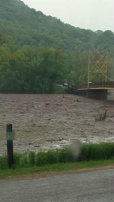
Picture of beaver bridge at eureka springs
-
I'm with you Crazy, wouldn't be surprised if he has stock in some of these manufacturers, If you think about it he is usually the one to announce these sales!!! LOL
-
James River predicted to get 40 feet over flood stage
96 CHAMP replied to Phil Lilley's topic in Table Rock Lake
Looks like it will be as bad or worse than 2015. Lets hope not. -
If not you better be darn careful out there, the owners of pla-port told me just a bit ago there is debris everywhere and that the Kings is a log jam. Do yourself a favor and stay off the lake and don"t be a statistic.
-
Cool move wrench, just like you said!
-
Thanks for the post Pepe, sounds like you all had a blast and I reckon you got to meet the new owners of Lunker Landing.
-
James River predicted to get 40 feet over flood stage
96 CHAMP replied to Phil Lilley's topic in Table Rock Lake
Thanks for the information Mr. Lilley. -
I was wandering that myself Champ, along with the dropping temps and the forecast of much more flooding rains. Will it cause them to abandon the nest??
-
Indian Point Bonanza - Suspended Fish in Spring
96 CHAMP replied to Ben Gillispie's topic in Table Rock Lake
Way to go Ben! -
Thanks for posting that, I tried that knot out and like it, very simple to use. Thanks again!!
-
Yesterday after the OA tournament I went back out and did good, caught 3 nice keepers and quite a few others on a senko and shakey head. Today was definitely the opposite, got out about 9:30 caught a few kentucky's and that was it in the morning. Caught a nice flathead this evening with the shakey head,3-4#. Kind of expected this though after the front and north wind. Give it a day or 2 and things should improve. Good luck to you!
-
I am glad I finally got down to meet some of you guys, had a good time and all the food was great. Thanks to Quillback and Muddy Water for setting everything up. Thanks for blowing my cover Crazy, I guess I'll have to start throwing that little rig that doesn't catch fish!! Lol ?


