


Al Agnew
-
Posts
7,085 -
Joined
-
Last visited
-
Days Won
27
Content Type
Profiles
Forums
Blogs
Events
Articles
Video Feed
Gallery
Everything posted by Al Agnew
-
Well, it helped, anyway. Did one of my favorites today. Fishing was slow, but the river was moving well and I didn't have to work as hard as I usually do on this 14 mile float in late summer. Never saw a single person until a hundred yards above the take-out. Kinda embarrassed about that, though...I'd just broken off my lure in a weedbed, and said, out loud, a very naughty word. And then saw the guy sitting quietly on the bank.
-
Heck, I'm mostly retired, and even without the big projects, I'm busier now than when I was still painting 5 days a week. And the older you get, the faster the days go by.
-
Last summer out in Montana, the river was in great shape all summer, and we were there most of the summer, but...we had a big project, putting a new patio and new deck on the house. Mary and I did the deck ourselves, and it took well over a month; a month of very little fishing. I told Mary that I didn't want another summer to go by like that one, that I hoped we were done with big projects. After all, I'm turning 70 this year. So this summer started out being okay...no new projects were planned. But...we had started thinking about selling our Missouri house, and replacing it with something smaller and with less outside work to be done; I was tired of weeding a big yard with a water garden and lots of flower beds. And we were both tired of having to do a lot of housecleaning and the repair work that comes with a house. We had built this house back in 1991, and it was starting to suffer the little problems that a 30 year old house always shows. We weren't really serious about it...until we mentioned to our nephew and his wife, who live nearby, that we were thinking about selling it. They immediately said they'd buy it in a heartbeat if they could afford it, and in fact were wanting to sell their house right away. Well, we agreed quickly upon a price, and suddenly Mary and I were looking at having to move out of the house by the end of the summer. At first, we thought about enlarging our little off grid cabin on the Meramec and moving out there. We even drew up plans for an enlarged living room, second bedroom, and second bath, along with a two car garage. But it was contingent upon being able to get electricity to it. We had plans to come off the neighbor's campground with the electric line; it was the nearest electric supply, and would only entail about a quarter mile of a cleared powerline swath through the woods, mostly on our own land. But the campground people, who had at first said they had no problem with it, kept dragging their feet on signing the agreement, until it was obvious that they weren't going to let us do it. So that meant somehow getting a line down the lane to the cabin from the highway, which entailed a mile and a half across two other owners' land...which was just too expensive. So we realized we had to find a place to buy, and find it fast. This was all happening in June. I stumbled across a place on Zillow, out in Crawford County, about 10 miles from the Meramec and five miles outside of town. 10 acres, near the end of a dead end road with several other houses along the road in but no really close neighbors. We looked at the house. At first glance it looked good. But we had a home inspector check it out...there were a lot of problems. So we backed out of the deal, and went back to looking. We had hired a friend to be our buyer's agent on that house, and when it fell through, he had an idea. A few years previously, he had told us about a house on the Meramec near St. Clair that was going to come on the market. We had been interested in it then, but then the owners decided not to sell. Our friend, who knew one of the owners (it was a family that owned it and used it as a vacation place) called him and asked him if they were ready to sell. He said he hadn't thought much about it, but that they might be. Long story short, we lucked into the place, which is on a bluff overlooking the river and has a good chunk of acreage and river frontage. Bought it at the end of June. We didn't have to move out of our old house until August, so we decided to spend July in Montana. Now...I hadn't fished much in June because we were house hunting and starting to pack stuff up for the move. And when we got out to Montana, the river was still high and muddy from the record flood a few weeks previously, as were most other streams in the area. So I didn't fish in Montana but a couple times near the end of July, and then it was time to get back to MO and finish packing. The move went okay; we hired a moving company but still carted a lot of stuff out ourselves. And the problem with the new place was that it was two stories, with the lower level just a four car garage and a LONG flight of narrow stairs up to the living space on the upper level. I carried about 75 boxes of stuff up that flight of stairs (11.5 feet from lower floor to upper floor), storing them all along the walls. By the time the movers got the furniture up (and our sofa wouldn't even fit up the stairs), it was obvious that we needed to do something different. So...we drew up plans to finish the lower level as our main living space, and turn the upper level to office and studio space. Found a builder, and we're scheduled to get the "remodel" done this fall. We've spent the last couple weeks making the upstairs livable until the downstairs is finished, and now we have to start shopping for appliances and flooring and fixtures and such. So...another summer almost gone, and not much fishing. I haven't fished but one morning since we got back from Montana. This will end up being a record for the least fishing I've ever done in a summer. And once again I'm saying, NO MORE BIG PROJECTS--after this one.
-
Cedar Strip Canoe in process.
Al Agnew replied to Daryk Campbell Sr's topic in Tips & Tricks, Boat Help and Product Review
Dang...the canoe is looking really great. Do you have a plan to fix the goober? -
Sorry...it seems to me that you were pretty specific that you think we are wanting to ban things we don't like just because we don't like them. I gave you my reasons why I think some uses are incompatible with every other use. You just repeated what you'd said before. Can't have much of a conversation if you're just going to repeat your statement and ignore what I actually said. There are a lot of things people do on Ozark streams that I don't like. I don't advocate banning most of them. And I gave you my bona fides to show that I'm not just some elitist paddler who hates all jetboats.
-
Oh, bull. You're darned right I have AS MUCH right to a public resource as anybody, and this kind of jet boat use negates my right and everybody else's other than theirs. That's the point. Some uses are incompatible with every other use. They make any other use unsafe for the people wanting to do it. Note that I'm mainly talking about high speed jetboats on small streams, but did you happen to notice that there were no other boats on the water during this race? Why? Because it would be unsafe for any other boat, or fisherman, or swimmer, to be on the water. And spare me the "paddlers do more damage". Paddlers leave litter, which is easily cleaned up. Jet boat wakes on small streams tear up banks and turn the water muddy. Both are far worse than litter. And numbers have nothing to do with it. One kayak does not come close to equaling the impact of one jetboat. Even in the typical Ozark stream situation. I own a jetboat, and I do a lot of canoe floating. I KNOW, beyond a shadow of a doubt, that I leave practically no trace of my passage in the canoe, but I leave a lot of traces when I'm in the jetboat. Which is why I don't push the envelope with the jetboat; I only use it on streams large enough that it somewhat minimizes my impact. (And I avoid the stretches of stream that have a lot of kayak, raft, and canoe rental use in the summer season, because I don't want to have to deal with trying to be safe and considerate around a lot of inexperienced paddlers.)
-
Some uses are simply incompatible with most if not all other uses. Thus some people monopolize the water. If these high speed racing style jetboats come to the kind of water in MO that they run in some parts of North America, all other uses of that water suffer. And that isn't even taking into account the damage they would do to the resource itself.
-
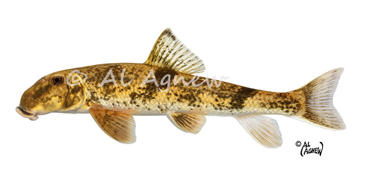
I wonder if you're misremembering the "hog molly" thing. Every Ozarker I ever knew called hogsuckers hog mollies. They called redhorse, which is what the suckers in the photos are, "yaller suckers". Here's my northern hogsucker scientific illustration:
-
A lot of states, Missouri included, don't have the guts to outlaw this kind of extreme jet boat stuff. If you watch some of the videos, some of those guys are running creeks way too small for ordinary jetboats, and it's only a matter of time before it gets popular in this state. In Montana close to where we are, a small group of idiots started running the Shields River in those little super high speed jetboats...the lower Shields is about the size of rivers around here that are barely floatable and totally unrunnable by ordinary jetboats. The Fish and Game Commission immediately stepped in and put a stop to it. Heck, they don't allow ANY motorized craft on the upper Yellowstone down to Big Timber. They were smart enough to nip this stuff in the bud.
-
I went turkey hunting one time with the Beav and Eddie Haskell. Jerry Mathers was a nice guy. Eddie, whatever the heck his real name was, was just as big a jerk in real life as he was on the show.
-
Well, I always found a canoe rental place and called them and asked them what the river looked like. Of course, they were likely to say it was looking great even if it was three feet above normal and chocolate milk, but I learned which ones I could somewhat trust. Back in the old days, somebody, I think MDC, put out a published list of canoe rentals, as did Arkansas Game and Fish. And River Hills Traveler had a bunch of them in eastern MO. I kept these lists in a file. It's amazing the way things have changed.
-
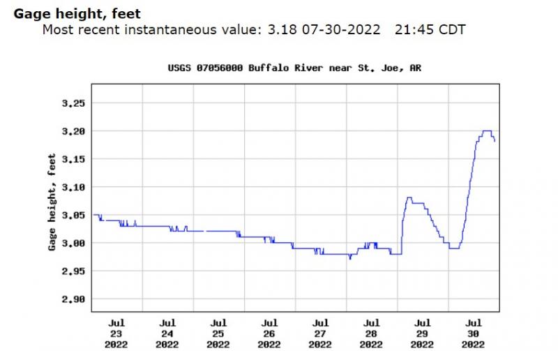
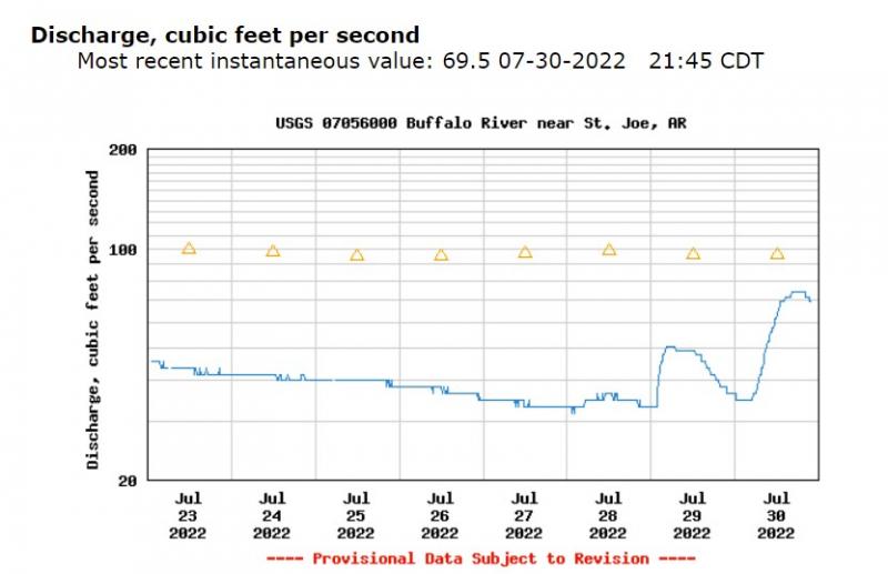
And again, that's not what I'm talking about. If you're familiar with the river, you know what level in feet ON THAT PARTICULAR RIVER is. What I'm saying (again and again) is that if you get used to using flow in cfs, you will know what an UNFAMILIAR river is doing based upon flow in cfs, while you can't do that using level in feet. Here is another example of what I'm talking about. Let's say you want to head down to Arkansas and float the Buffalo River. I'm going to assume you aren't familiar with gage readings on the middle Buffalo. So you call up the St. Joe gage (because hopefully you know that it's on the middle river--it's actually at the Highway 65 bridge, which you can ascertain by looking at the location on the drop down menu near the top of the page). Here is what the graph for height in feet is showing right now:Okay...you now know the river was pretty stable, just dropping slowly, until yesterday, and then it came up an inch or so, dropped back down, and then came up about two inches today. But...was it high enough to float before today? Is it high enough to float right now? All you know from this graph is that it came up a couple inches. You don't know how it was before it came up unless somebody like Wrench's counterpart down at Gilbert tells you what 3 feet on the gage signifies. Now, here is the graph for flow in cubic feet per second:Now you can see several things. You can see the river was flowing somewhere between 30 and 40 cfs until that little rise yesterday. The rise today only brought it up to 75 cfs or so and it's already under 70 cfs. Remember my rule of thumb that you need 100 cfs for fairly clean floating without scraping and dragging and possibly walking? You now know the river was way too low for clean floating before that little rise, and is still too low for easy floating. And see those little triangles? They denote the median flow for each day. Median is hanging around 100 cfs. So now you know the river in this stretch is usually floatable but just barely without all that scraping and dragging this time of year, but it had been and still is lower than normal right now. See what I mean? The graph for level in feet gives you no info other than the river had a tiny rise. The graph for flow in cfs tells you EVERYTHING you need to know. And actually, I use the graph for level in feet for exactly what it DOES show you. Like you, I can picture a 2 inch rise or a 2 foot rise or a 5 foot rise in my mind. On an unfamiliar river, I always go to the flow in cfs FIRST, to see if the river is close to normal, what normal is for that river, whether normal is floatable this time of year, and whether the river is now floatable. But if there has been a rise, as is the case on the above graphs, THEN I go to the level in feet graph to get a bit better picture of the extent of the rise. And that's ALL I use the level in feet graph for. This example is not a good one, because I will already know that a rise that only increases flow by 50 or so cfs is not a significant one. But if the rise shown was, say, 200 cfs, I won't know for sure how significant a rise that is, so I go to the level in feet, and let's say it shows a 2 foot rise. Okay, now I know that 2 feet could maybe be enough to muddy up the river.
-
Wrench, I don't like arguing, either, believe it or not, but you're just plain wrong on most of this. First of all, almost NONE of the gages will ever read zero, and yet the one gage I mentioned above gives a MINUS reading when the river, which is pretty big, is flowing normally. And none of it ever has anything whatsoever to do with losing reaches. Gages are only accurate in the sections of streams near where they are. For instance, the Hazelgreen gage will only be reasonably accurate for between the mouth of the Osage Fork upstream, and the Roubidoux downstream (taking into account the losing reach of the Gasconade that's a few miles upstream from the Roubidoux). Any time a major tributary comes in, it can be flowing high when the rest of the river is low, and therefore a gage reading (either feet or cfs) is not going to give you a good picture of what the river is doing above the trib if that tributary is above the gage, or below the trib if it's below the gage. So if I see a reading of 150 cfs on the Hazelgreen gage but Roubidoux Creek is coming in high and muddy, I sure can't use the Hazelgreen gage to tell me if the river is fishable below the Roubidoux. Plus, a reading of 150 cfs doesn't give me a true picture of the losing reach that's below there, either. I've floated the losing reach when the Hazelgreen gage was reading over 100 cfs and it was probably flowing no more than 30 cfs in the losing reach. And no, the gages aren't really carefully placed so that a reading of 2 feet, for instance, is the same for every gage. I've already demonstrated that above. They CAN'T be. It can't be done. Because the gage is dependent upon the stream profile at the spot where it's placed. If that gage happens to be placed on a bridge with a deep pool underneath it, it only makes sense to bury the end of the gage a few feet deep in the pool when it's at normal level. But another gage might be placed where there is a shallow riffly area beneath the bridge, and they CAN'T bury the gauge more than a foot or so deep in the water. So they don't worry about it. They set up the gage however it works. Then they carefully MEASURE the flow in cfs at the gage, and correlate it to the gage height reading. Then they wait until there's a rise on the stream, and go out and physically measure the flow again, and correlate it to THAT gage height. They do this several times at different gage heights, and then they kinda fill in the blanks. It ends up being pretty darned accurate. But they still periodically go to the gage and measure the flow again to make sure it's still correlating to the gage height correctly. You end up with a very accurate flow in cfs reading. And no, I can't measure cfs on a stream with no gage unless I'm right there to see it. When I AM right there to see it, I can tell you approximately what the flow is as long as I can look at a riffle, and as long as the stream is at a reasonably normal level. Because I KNOW what 30, 50, 75, 100, 200, 300 cfs looks like on any river in the Ozarks, so I can probably guess it from looking at it and be no more than 20% off. But you can't do that using level in feet. Because 2 feet, or 4 feet, or 0.5 feet, means absolutely NOTHING in itself. All it is is the level of the float in the gage at a particular gage; it has absolutely no relevance to any other gage. It's like if you happen to know that a level of 2 feet is perfect for fishing the Gasconade at Hazelgreen, and you go to the gage for Big River at Desloge. For one thing, you won't ever even SEE a reading of 2 feet on that gage...it doesn't ever go that low. But if you see a reading of 4 feet on that gage and you think it's 2 feet higher than the Gasconade is at Hazelgreen, you'd be totally wrong, because 4 feet on the Desloge gage is close to normal and just about perfect for fishing and floating. That's my whole point that you keep glossing over. Flow in cfs IS the same for any stream because it's a measurement of the VOLUME of water flowing past a given point. Level in feet is not the same for every stream, or ANY stream. A reading of 2 feet on the Gasconade at Hazelgreen is not the same as a reading of 2 feet on the Gasconade at Jerome, even, let alone a reading of 2 feet on Big River at Desloge. But I can see the Gasconade flowing at 150 cfs, and Big River at Desloge flowing 150 cfs, and know they are flowing the exact same volume of water. You and I both love fishing low water conditions. But a lot of people don't want to do a lot of dragging, and the original question here reflected that. I know I don't mind floating at 30 cfs, understanding that I'll be walking some riffles. But when I'm advising people that I can't judge their level of tolerance for dragging and scraping and walking, I use the 100 cfs figure because that's the point where there won't be a lot of dragging and walking.
-
Wrench, that's not really how gage height works. Every gage is different when it comes to gage height. 0 is not necessarily bone dry, and gage height doesn't necessarily increase as you go downstream, nor does a level of 2 feet on one gage have any relationship whatsoever to 2 feet on a different gage on the same river, let alone other rivers. Let's take the Meramec River system. There are six gages on stream sections that are floatable part of the year but can get too low to float. Here are the gage heights corresponding to the median (normal) flow for today on each, and what 100 cfs, my rule of thumb for floatability, equals on each: Meramec, Cook Station--median 24.0 cfs, equals 1.65 feet. 100 cfs equals 2.51 feet. Huzzah--median 93 cfs, equals 2.17 feet. 100 cfs equals 2.21 feet. Bourbeuse, High Gate--median 2.4 cfs, equals 3.14 feet. 100 cfs equals 4.61 feet. Bourbeuse, Union--median 80 cfs, equals 2.03 feet. 100 cfs equals 2.13 feet. Big, Irondale--median 17 cfs, equals 0.78 feet. 100 cfs equals 1.73 feet. Big, Desloge--median 81 cfs, equals 3.77 feet. 100 cfs equals 3.9 feet. Now...there are four gages on the most fishable jetboatable stretches. Here are the median comparisons and what the flow at 500 cfs equals for them: Meramec, steelville--median 186 cfs, equals 1.36 feet. 500 cfs equals 4.39 feet. Meramec, Sullivan--median 391 cfs, equals 2.8 feet. 500 cfs equals 3.02 feet. Meramec, Pacific--median 951 cfs, equals MINUS 0.9 feet. 500 cfs equals MINUS 1.6 feet. Big, Richwoods--median 187 cfs, equals 2.36 feet. 500 cfs equals 3.41 feet. So as you can see, the level in feet corresponding to similar flows is all over the map. If I knew that my home river, Big at Desloge, is good floating and fishing this time of year at 3.9 feet, (which corresponds to 100 cfs), and tried to use that number for, say the Bourbeuse at Union, 3.9 feet would be almost 2 feet above normal for that stretch of river. And on the Huzzah, 3.9 feet would be 1.8 feet above normal. Yet all three stream stretches are similar in size and normal flow rate. Note also that just on the Meramec, normal level at Cook Station is 1.65 feet, at Steelville (next downstream) it's 1.36 feet, at Sullivan 2.8 feet, at Pacific -0.9 feet. There is nothing like increasing gage heights the farther downstream you go. Fact is that gage height is always an arbitrary figure. They stick the pipe in with the float inside it that measures and reports gage height, and all they do (usually) is make sure that the bottom of the pipe, corresponding to zero, is well below the normal river level. They don't care how far below it is, that doesn't matter. And if a flood changes the river bottom there, the bottom of the pipe might be deeper in the water or covered in gravel. You can find out all these figures in each river gage page, under "Current stage-discharge rating". It will give you the table that they use for each gage that shows the flow in cfs that corresponds to each increment of gage height. And that table will be completely different for every gage. As for some streams being very floatable at a lot less than 100 cfs, it depends upon what you consider floatable, I guess. But on every stream I've floated at flows well under 100 cfs, I was scraping bottom on a lot of the riffles and walking a few, or many. And I do a LOT of floating bony water. The 100 cfs figure holds true on the following rivers, for sure: Little Piney, Big above Washington State Park, Bourbeuse, Meramec above Maramec Spring, Huzzah, Castor, Big Creek, St. Francis, upper James, Beaver, and Jacks Fork. Doesn't mean I won't float any of them at lower flows...I've floated Big River at Irondale at 7 cfs, Jacks Fork at 25 cfs, St. Francis at 9 cfs...but I walked every riffle. On my home stretches of Big River, it's not unusual for the river to be flowing 30-50 cfs, and I can float SOME riffles cleanly at that flow, but I'll scrape bottom on most and have to walk a couple.
-
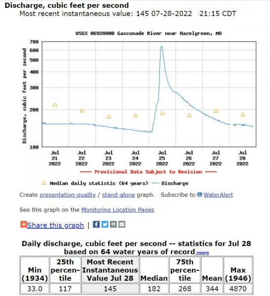
I disagree completely. Flow rate is the same volume of water for every river in the Ozarks, and I don't NEED to be familiar with the river to know exactly what it's doing with a given flow rate. I KNOW, because I can picture what it looks like in my mind on rivers I AM familiar with, what 100 cfs or 150 cfs looks like in a typical riffle in any stream in the Ozarks. So I can use some simple, easy to remember rules of thumb, that have always held true (with one exception that I'll get to in a bit) whenever I'm wanting to know how floatable (or fishable or jetboatable) an unfamiliar Ozark river is. Rule of thumb 1: you need 100 cfs, an easy number to remember, to float any stream in the Ozarks without doing a lot of dragging, scraping, and maybe some walking. You might still have to drag a kayak or canoe down a riffle if it's exceptionally wide, or if it has split channels, but you'll still be able to run most riffles. There is a slight difference depending upon how much river and watershed there is above the gage; for instance, there's a lot of river and watershed above Hazelgreen on the Gasconade, and therefore the river channel will be wider than, say, the upper Jacks Fork, with a short section of river upstream from the Buck Hollow gage. So 100 cfs will be a little easier floating on the Jacks Fork than on the Gasconade at Hazelgreen. But not a huge difference. Rule of thumb 2: On an unfamiliar river, I want at least 500 cfs to feel like I can jetboat it safely, and even then it can be iffy. I routinely run one familiar river at 200 cfs, but there is a pucker factor at that flow. Rule of thumb 3: Use the median flow, which is always given in cfs. Median is a good approximation of normal flow for that time of year. It will tell you whether the river in that section is usually floatable (remembering the 100 cfs rule--if median flow in mid-summer is over 100 cfs, the river is usually floatable throughout the summer). And in the spring, when median flows are highest, I feel reasonably comfortable with a flow up to 3 times the median; the river will probably still be floatable and fishable. In midsummer, when median is a lot lower, it can be 4-6 times median and still possibly be fishable, depending upon how fast it's dropping. So...to answer the original question using flow in cfs on the gage...Here is what I want to see on the Hazelgreen gage right now. I note that the river is flowing 145 cfs. That's a bit above my 100 cfs rule of thumb, so I know the river is floatable without a whole lot of work. I note that the median, normal flow for right now is 182 cfs, so the river is usually floatable, is a bit lower than normal for this time of year but still should be floatable. And looking at the graph instead of the table of Daily discharge, I note that the river had a bit of a rise three days ago, was dropping back to normal the last two days, and is now leveling off today, so it should be in pretty good fishing shape; I want to see a leveling in flow and not see the river still dropping rapidly. I live 100 miles away, and I wouldn't hesitate to drive 100 miles to float it tomorrow just on what I'm seeing on the gage...and I am NOT familiar enough with the river to know what any level in feet signifies. The only time a gage reading might not be accurate in flow is when there has been a flood and the shape of the river bottom has changed at the gage location. Then, the flow, which is extrapolated from the level in feet, might not be correct...until some USGS employee has a chance to check the ACTUAL flow and compare it to the table they keep matching flow rate to level in feet. But then the level in feet won't be correct either when it comes to figuring out how floatable or fishable the river is at that moment.
-
I use hair jigs only in the winter. I've tried them in warm weather, but have never done well on them then, compared to some other lures I use. Hair isn't magical. It works. It is seldom NECESSARY, if ever, but sometimes it's the best choice. And different kinds of hair are called for in different situations; all hair is not equal. My winter jigs are made of rabbit strips. In warm weather I use bucktail on my homemade twin spin. And that's pretty much the extent of my hair use.
-
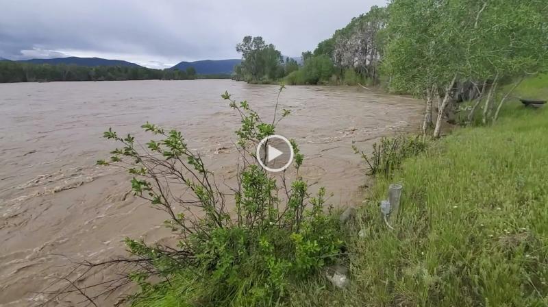
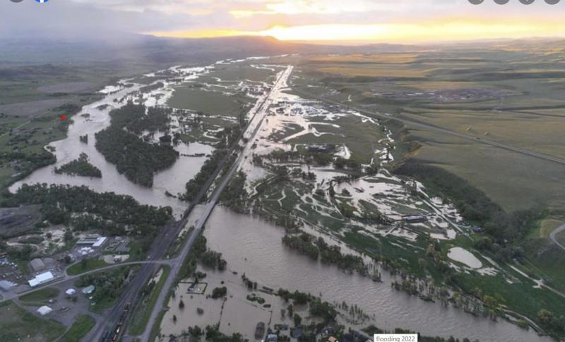
Mary and I were in Missouri when the big flood hit the Yellowstone River. I had never worried about our house on the river flooding; according to the flood plain maps it was high enough to never flood. The river had seen a record high a couple years after we bought the house, and the water didn't come more than halfway up the bank next to the house. But hearing and seeing from our Livingston friends about the flood, I must admit I got a little uneasy. The water was SO much higher than the record. I was still pretty sure it wouldn't get up to the level of the house, but I was a bit worried about saturated ground backing up our septic system and maybe flooding into the basement. The top of the bank is about 12 feet higher than normal river level, and the house ground floor sits about 2 feet higher than that, but it has a finished basement, so the floor of the basement could easily have been lower than the height of the river. Our friends called and told us they were going to watch the flood peak from our yard, so I asked them to go in and check the basement. It was fine, and I breathed a sigh of relief. They arrived at the house late in the afternoon, and the flood peaked at the house about 11 PM. This photo was taken from our yard looking upstream (pay no attention to the video play arrow; I can't get the video to load right now):The video was taken standing at the top of our bank. You'll notice a post with an electrical outlet near the water; at the peak of the flood, the full force of the river was crashing into this bank and causing a bulge of at least two feet, and water surrounded the base of that post. Another foot and it would have spilled out into the yard at that point, even though a bit farther down the bank where the water leveled off, it stayed about three feet below the top of the bank. I found a screenshot on Facebook that shows an overview of the river the morning after the peak of the flood; at this point the water had gone down a foot or so. I put a little red dot where our house sits. You'll note that the water spilled far out into the valley on the other side from the house, because that side is lower, and that's what kept it from getting higher on our side:The other thing I was worried about was our bank itself. It is underlain by bedrock that outcrops about three or four feet higher than normal river level, so I wasn't too worried about it getting eaten away significantly, but we'd just spent a lot of money and effort last summer clearing out a lot of trash and debris that the former owners had thrown onto that bank to keep it from eroding, reducing the steepness of the slope, and covering it in topsoil and vegetation. When the flood went down, about half the length of the bank had lost all the vegetation and was just rock. We got back out to Montana about three weeks ago, and the river was still high and muddy. But it was obvious that it had changed significantly in front of the house, and not for the better for my fishing purposes. When we bought the place, there was a half-mile long wooded island in front of the house, with nearly all the river on the other side of the island; only a small channel was on our side, just big enough to have some nice pools that held a lot of trout. But the river has gradually shifted toward our bank, and after this flood, more than half the river is on our side and it's pretty much unwadeable. The river finally dropped and cleared enough to be fishable this past week. So yesterday I loaded up the little Water Master one person raft and had Mary drop me off for one of my favorite floats, Pine Creek to Carter's Bridge. I got on the river about 10 AM, clear skies, gentle wind, promising to get hot in the afternoon. The river clarity was about 18 inches visibility, which is often good for streamer fishing, so I tied on a streamer on one rod and nymphs on the other, planning to fish the streamer while drifting and to stop at every good "riffle corner" (places where there is an eddy with a good eddy line at the bottom of a riffle) to drift the nymphs. And I immediately hooked a nice brown on the streamer along a shallow, rocky bank on the inside of a riffle, the kind of place the guides usually don't fish. The river had plenty of boats, many of the guides and clients, so I decided to fish those kinds of places that they don't fish. Soon I got another good fish, a rainbow this time, and then picked up three nice rainbows and a small brown in the next couple riffle corners. Then the fishing slowed as the sun got high overhead. I was still picking up a few, though more whitefish than trout. But it was a great day to be on the water. I WAS intimately familiar with this stretch, but the flood had completely altered it; it was like fishing a new river. By about 4 PM, I was within a couple miles of the take-out and the fishing was totally dead. So I decided to just row on in. And that's when I entered the twilight zone. I was rowing down a steep, wide, shallow riffle when I somehow jammed an oar into the bottom and wedged it in the rocks. Nearly flipped the little raft, and broke the shaft of the aluminum oar. I paddled over to the bank with my swim fins, nearly losing one of the swim fins when it came off my foot doing such heavy flipping. I had it tethered to my shoelace because I've lost swim fins before, but just as I grabbed it (fortunately I was in shallow water at that point or it would have sunk out of sight), the tether came loose as well! Okay...dodged a bullet with that one. I thought I could find a piece of driftwood that I could wedge in the two halves of the oar shaft and limp on down to the take-out, but after finding what I thought might be the right diameter driftwood branch, I discovered that there was a plug in the shaft and I could not jam it far enough into the shaft to make it work. Okay...I'd just have to paddle on in with the swim fins alone. But in order to do that, I had to make sure I wasn't going to throw a swim fin again. So I dismantled the buckles on the swim fins to redo them more securely...and somehow, while sitting in three inches of water in the raft with my feet on the bottom in the opening in the middle of the raft, I dropped one of the pieces of the buckle...a vital piece...and COULDN'T FIND IT. I looked for that thing for fifteen minutes with no luck. Now my only option was to try to attach the strap without that piece, and the only way I could think of to do it was to cut a slit in the rubber strap and stretch the hole over the peg on the fin...and hope it stayed. I reached into my pocket for my ever present pocket multi-tool...and it wasn't there. I ended up using the line cutting scissor on my hemostat to cut the slit. It worked, though I made especially sure to really tie my tether down well to the fin and to my shoe. And started down the river. Had to cross the river at the next riffle, then could see I had to cross it again. The river is about 150 yards wide at that point, and I was really working myself silly getting across with the swim fins. At that point, the river swings next to the highway and there is parking along a high, rip rapped bank. So I called Mary and asked her if she could come and pick me up there. She said she would head that way (about a 15-20 minute drive from the house). I pulled into an eddy on that rip rap bank, and dragged the little raft up it (fortunately it only weighs about 40 pounds)...and somehow broke the butt section of my Sage 6 weight rod! So now I'm out a swim fin, an oar, and a favorite rod. I'm kinda glad we have to come back to Missouri soon!
-
Affordable housing in Wyoming and Montana is about as rare as a unicorn these days. Really glad you found a place to live. Just saw a listing for a 925 sq. ft. cabin "with a view of the Tetons" for $1.5 million. A whole lot of people who work in Jackson live over the other side of the Tetons in Idaho, and have to commute over the pass every day. It's the same in Bozeman (and Livingston) Montana...there simply isn't any affordable housing. If you don't already own a place and you're an ordinary working stiff, you aren't going to find anything you can afford. Meanwhile, almost everybody who owns rental property in the area is renting it out VRBO and making more money during the tourist season than they can make renting it full time. I know people who bought an RV and live in it all summer while renting out their house. I know what you mean about indicator nymphing especially. At least 80% of what the guides do on the Yellowstone is have their clients watching bobbers while they drift down the river. It's the most no-brainer fly fishing you can do, as long as the guide has good enough boat control to keep that indicator on a good line the right distance off the bank. I hate it partly because if you're REALLY getting your nymphs in the right spots, you're going to be hanging up pretty regularly, and I get tired of tying on new flies. However, I must admit that I do a lot of nymphing when floating the river with my wife or by myself; I stop at any good current seam at the bottom of a riffle and drift nymphs along it...there usually isn't as much to get snagged on in those places.
-
It's one reason I prefer fishing rivers. The fish are right there in front of you, you don't have to figure out where they are. Makes me look competent at fishing!
-
House moves to repeal the Pittman-Robertson act.
Al Agnew replied to Gavin's topic in Conservation Issues
Let's assume, for a moment, that a percentage of the Pittman-Robertson money is being wasted. These legislators want to repeal the act. They want to cut off ALL the money. Which means that they are cutting off the well-spent money with the wasted money. Without replacing it with anything at all. So why in the heck anybody who gives a crap about hunting, fishing, and conservation can be for this is simply beyond me. It's cutting off your nose to spite your face. -
I've advocated for using length rather than weight for a long time. It eliminates a LOT of the problems with weight, including making sure all scales used are perfectly calibrated and accurate. And in so many ways, it's a truer measure of the skill of the angler. With weight, you're depending upon the luck of such things as how healthy the fish is, what it just ate, etc. The 20 inch fish you just caught might weigh 4 pounds if you caught it during the spring or after it had just eaten a 10 inch redhorse, but that SAME fish might weigh 3.5 pounds at the end of August without having eaten anything for a few days. Same fish. Didn't take any more skill to catch it when it weighed 4 pounds than it did when it weighed 3.5. AND, if you measure and immediately release, you aren't constrained by limits. What if I can go out and catch 30 fish over 12 inches in a day, including a best five or six that were all over 17 inches, but some other guy beats me out having caught 6 fish all day, but one of them just happened to be 21 inches and and his other best four were all slightly over 17 inches? Who is the better angler, me who put 30 in the boat, or the guy who put 6 in the boat but lucked into one really big one and beat my best five by a quarter inch because of it? So why not allow every fish over 12 inches or 14 inches or whatever to count, no matter how many you caught, since you are quickly releasing them anyway?
-
This certainly confuses many people. Here is the deal: you must register outboards. You must also register the boat that the outboard is on. Trolling motors are exempted from being registered THEMSELVES. But putting a trolling motor on a boat means that the boat is now a motorized craft and must be registered. If you don't have a bill of sale, you can't title the boat. If the boat isn't titled, you can't register it and get the numbers for it. You CAN contact the Highway Patrol and have them inspect the boat and check the serial numbers to make sure it hasn't been reported as stolen, and then they can give you a waiver and you can get it titled and registered. However, I've never heard a good story about that happening. Doing it is apparently WAY down the list of priorities for the State Patrol. I used to register and title my canoes, because I occasionally used them in other states that require paddle craft to be registered (Minnesota, for instance). But when I decided to try a trolling motor on one of my solo canoes, it wasn't registered and I didn't have a title for it, so I thought about going the Highway Patrol route, but was told that it was a huge hassle. So I just took my chances. Never had a problem, but also rather quickly decided the trolling motor was more trouble than it was worth.
-
While that's true that very few, if any, other people will ever catch an Ozark river smallmouth that big, I don't think you have to catch one that big yourself before you can question the claim that somebody else did, unless the photos truly show it to be that big. Like I said, I believe Jeff. But it's an extraordinary claim, and extraordinary claims will always demand proof. Doesn't really matter, as nobody is claiming it as an actual record. It's just an amazing fish that was caught and quickly released.
-
I believe it was caught on a crankbait.
-
Had a lot of discussion about that photo and that fish on Facebook. Plenty of people don't believe it was 23 plus inches. Since Jeff was wanting to get it back in the water as quickly as possible, he measured and weighed it quickly and held it while a couple quick photos were snapped, and then released it. It is unfortunate that he didn't get a photo of it on a bump board or against a ruler, because it gives people a lot of opportunity to question how big it really was. As for the weight...if it was indeed 23 5/8 inches, it COULD have weighed that much. Jeff caught one on the Meramec a few years ago during a tournament that was weighed on accurate scales at 6 pounds plus (I don't remember the actual weight), and nobody measured it. My own personal opinion is that Jeff isn't lying...I've only met him once or twice but I'm good friends with one of the guys he fishes with a lot. Since the fish was caught WHEN it was, there was no way to get it to a certified scale to be weighed accurately. It could have been a state record, or could have just missed.


