


Al Agnew
-
Posts
7,085 -
Joined
-
Last visited
-
Days Won
27
Content Type
Profiles
Forums
Blogs
Events
Articles
Video Feed
Gallery
Everything posted by Al Agnew
-
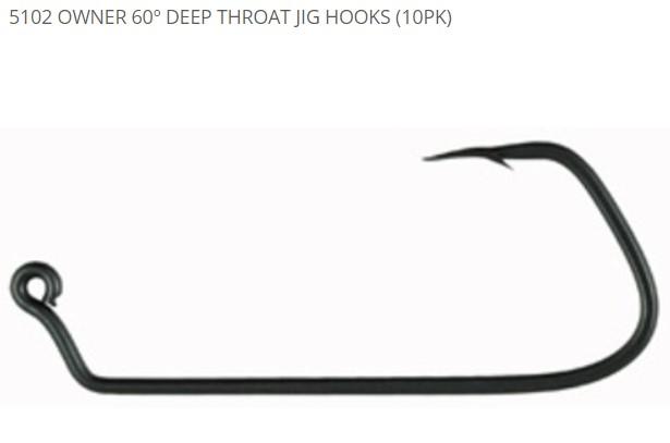
Put a double wire weedguard on that bottom one and it would be pretty close to what I was thinking of. And basically, I want Paul's jig heads, but on a 5102 Owner 60º Deep Throat Jig Hook. That's the exact shape of hook I want. I had a bunch of Mitch's jig heads that he had made for me years ago, and I was bending the hooks on them into that shape...but the hook would snap on about every fourth one.
-
I need to find somebody to pour some jigs for me. I know exactly what I want, down to the jig head shape, wire weedguards, and the exact hook...and NO company produces anything like it. And that's for hair jigs (I'll tie the hair myself) and a different head for swimbait jig heads. (But no company makes a mold for the shape of swimbait head I want.) I've thought about pouring my own, but don't want to take the time for the learning curve. Those jigs look sweet!
-
I like cats (better than dogs--I guess my psychology is closer to a cat's). But I don't hesitate to shoot feral cats, for the very reasons described. You can admire them as pretty cool critters and still know the effects they have on bird and wildlife populations. Had a calico cat for many years, that we really loved. She had a weight problem. But it didn't keep her from killing birds, mice, voles, and chipmunks. Think she also might have done a number on our flying squirrel population. We kept her inside most of the time, but anytime we'd let her out she'd kill something. I watched her stalk a group of adult hen turkeys going through the yard one time. Here was this really fat, black, orange, and white cat, flattening herself to where her back wasn't 4 inches off the ground, and seemingly just oozing like the Blob toward those turkeys. They finally saw her when she was almost within charging distance and calmly walked away.
-
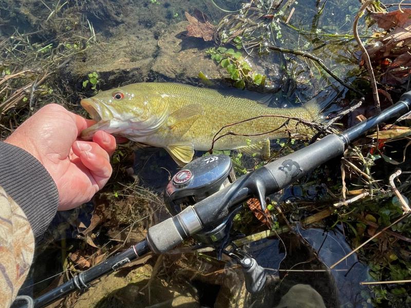
What's your first fish of 2022?
Al Agnew replied to Johnsfolly's topic in General Angling Discussion
Here's my first one...smallest of the day: And the biggest of the day: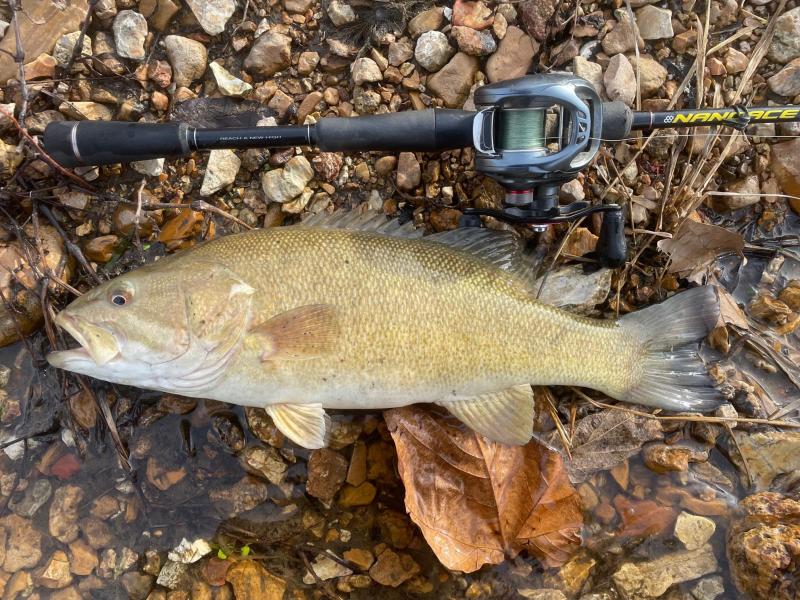
-
What's your first fish of 2022?
Al Agnew replied to Johnsfolly's topic in General Angling Discussion
I'll probably go tomorrow, and expect to get my first one then. It will probably be a smallmouth. I'll try to remember to take a photo of it. I should have quit 2021 a day before I did. Fished the afternoon of 12/30 and caught several nice smallmouth 15-16 inches. Fished all day 12/31 and got exactly five bass--1 spotted bass and 4 largemouth, and the biggest was barely 12 inches. Did briefly hook a giant largemouth that would have made the day and topped the year off very well...saw it clearly when it took a jerkbait, but it didn't stay hooked. At least 22 inches. -
Best winter river tactic or bait??
Al Agnew replied to snagged in outlet 3's topic in Smallmouth Talk
Was having a discussion on how much it weighed on "social media". We did weigh the 20 incher in the above photo...3.5 pounds. But look at the size of the tail on it compared to the rest of the body. And look at how much smaller the tail is on the one today. Geez, if that fish had a tail of the same proportions it would be 23 inches! I'm guessing it at 5 pounds, maybe a bit over. -
Best winter river tactic or bait??
Al Agnew replied to snagged in outlet 3's topic in Smallmouth Talk
It's been a weird year. I'm finding fish in some odd spots, and having to use some odd presentations. The long stretch of dry weather made the water super clear, and that can be really tough in cold weather. The absolute BEST winter stretch of river I know had plenty of fish, but the fishing was slow overall while the water was so clear. I tried a different river stretch that is usually pretty mediocre, and caught some little ones. Then a different stretch yet that is also usually mediocre, and caught a 19.5 incher on my fourth cast of the day (after catching a nice largemouth on the second cast), and ended up with a dozen spotted bass that I kept and several decent smallmouth. But I had to make long casts with a small jerkbait to catch fish. Then tried a different river, a stretch I'd never fished, with a friend who knew it well, after one of those warm spells a couple weeks ago, and guess what the only thing that worked was...TOPWATER. So tried it back on my home river the first cool day after the warm spell...water temps were still pretty high, and it worked again. Even caught one over 18 inches on it, and had blow-ups from several other big fish. You would have sworn it was August. Then the rain came, and now the rivers are in good shape. Caught a 20 incher on a crankbait and a couple dozen other fish the other day, and today got my biggest in probably 10 years, a 21.25 incher, on a swimbait. Weird today...the swimbait was the ONLY thing that was working (except for one 16 incher on a crankbait).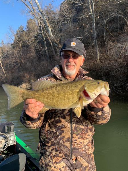

-
Best winter river tactic or bait??
Al Agnew replied to snagged in outlet 3's topic in Smallmouth Talk
Ask and you shall receive...21.25 incher today. It was a slow day numbers wise, only 13 smallmouth and a spotted bass. But all but two were over 15 inches. Caught a 17, 17.5, 18, and 18.25 in addition to this one. It's my biggest smallmouth of the year, and probably of the last 10 years.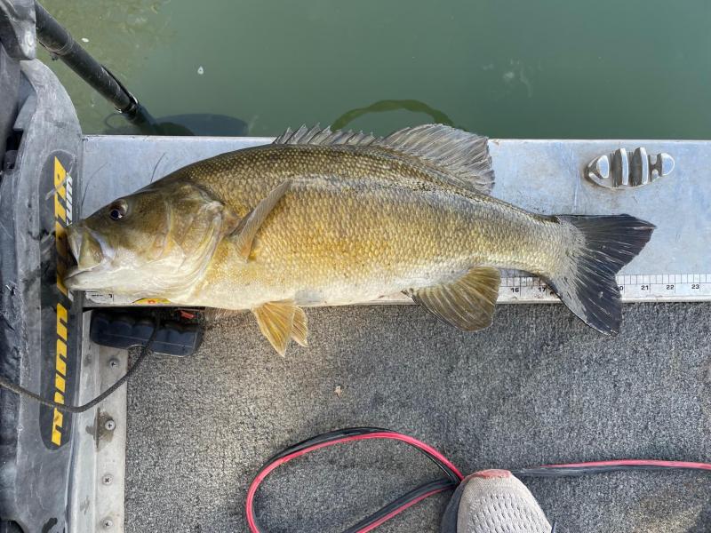
-
Best winter river tactic or bait??
Al Agnew replied to snagged in outlet 3's topic in Smallmouth Talk
There are PLENTY of lures that work for winter smallmouth. As Wrench said, they aren't smart. And as several have said, finding them is the key. 95% of the fish are in 5% of the water in the winter. However, the other problem is that, more so than in warm weather, even if you find them they may not be active. I've fished pools where I SAW the fish, hundreds of them, and couldn't get them to bite anything. So if you're just trying to find them, you might have found them and not even know it, which can be frustrating. I THINK I know what to look for in holding areas for winter smallmouth, yet there are pools that I just KNOW should be good where I've never caught much of anything. It's not an exact science. The only ways you figure them out are by going out and trying, or having somebody who knows where to fish for them show you. Getting back to lures...my winter tackle box consists of a bunch of my homemade hair jigs, a bunch of swimbaits, some deep diving crankbaits, jerkbaits, spinnerbaits, HD Craws, a few other soft plastics meant to be fished on the bottom (but not Ned Rigs, I refuse to fish them), and even a handful of topwater lures. I've caught winter fish well on every one of them. -
Back in the days when I used to do a lot of winter walleye fishing on Black River, I'd catch a mudpuppy now and then. We used big live minnows, really almost too big for a mudpuppy to swallow, but once in a while one would choke a 5 inch stoneroller down. Whenever we got bites from mudpuppies we pretty much knew we weren't going to catch walleye at that spot for a while...apparently big walleye will eat the things very well, so they aren't likely to show up where they would get eaten. They also had a weird way of attacking minnows; they would invariably first grab the minnow in the middle and try to chew into its belly. When you'd get a "bite", and the "fish" wouldn't run with the minnow but just tug on it steadily, we'd eventually get impatient and try to set the hook, and bring in a minnow with its gut chewed up. When we caught one, it was sometimes hooked on the outside of the head. They got up to about 12 inches long, and they were pretty slimy and the slime would stick to your hands when you tried to handle them. And yes, they had pretty strong jaws and would chew on your hand like they chew on minnow bellies. As somebody said above, the difference between mudpuppies and hellbenders is mainly that mudpuppies have external gills, hellbenders do not. They also look a lot different, and hellbenders get considerably bigger.
-
Haven't been on here for a bit, so didn't see this thread until now. Mary and I were still out in Montana. We didn't set an alarm to see the eclipse, but happened to wake up at the perfect time, about 30 minutes before the maximum. Our hot tub is right outside the bedroom, so we just jumped in with our binoculars and watched it for that 30 minutes. Air temp in the low 20s, water temp 103. Can't beat that!
-
Well done. It's a tough creek to fish.
-
Good point...I should have said that so far my eyes still allow me to see very well with whatever corrections I have. I've been told that cataracts are down the road a bit. I can still remember getting my first pair of glasses...it was in 1964; I was 12 years old. What convinced my parents to get me to an eye doctor was that I was complaining that I couldn't watch the World Series (with the Cardinals in it) on the TV that was up on the stage of the auditorium at my school...yes, my junior high teachers could opt to let us out of class during the games to watch them in the auditorium. I can still remember being amazed that with my new glasses I could see individual leaves on the trees.
-
So far, at age 69, my eyes still give me no problems. For a while, like about 6 months, I was having a weird thing happen where if I concentrated on close-up work for too long, the center of my vision blurred. Worried and worried about it until finally going to the doctor, got a thorough checkup, and was told it was simply due to eye fatigue. Got new glasses, transition trifocals for all my art work, and problem went away. My wife got Lasiks 21 years ago, and is still happy with it. She was more near-sighted, but had less astigmatism, than I do. I thought about it after she was so pleased with hers, but was worried about two things at the time...first, I was still able to take off my glasses and do really closeup, finely detailed work with no glasses as long as my eyes were within a foot of the work, and I was afraid that the Lasiks would affect that, as at the time that was completely the kind of work I was doing. Second, I was still doing a lot of night fishing at the time, and was worried that without glasses, I was unprotected from Jitterbugs flying back in my face! My other vision/glasses issue was wearing prescription safety goggles while playing basketball. I have scars on my face from having balls and elbows hit my glasses while playing (one time the same guy put me and another player in the emergency room the same night with his elbows). I tried a pair of prescription goggles, and had terrible depth perception (not good for your shooting percentage) because they were wrap around and the lenses were curved too much. Got a pair with flatter lenses and it was a lot better.
-
It's simply amazing when you think about it how much information is available at our fingertips. I wasn't curious enough to look it up for myself, but I should have known the explanation could be found. Thanks!
-
Given the size, it could only be a silver redhorse or a river redhorse, and since silver redhorse are usually, well, silvery, and river redhorse typically have a golden tint, I'd say it's probably a river redhorse. It also appears to have parallel folds on the lower lip, which is a characteristic of river redhorse. So I think that's the best guess.
-
Glad I was a help. One of the beauties of the USGS gages (if you know where to look and what you're looking for) is that they can tell you a huge amount of useful information about streams you may know nothing about. If you're familiar with the river and the particular gages (or the apps) that cover it, then pretty much all you usually need to know is either level in feet or flow in cfs, the median flow, and what the river has done in the last few days. But if it's a completely unfamiliar river, or one that you've only been on a couple of times, then digging deeper into the USGS gages will really give you a lot.
-
There is a huge amount of info you can get from the USGS gages. 1. Exact location of the gage. 2. Number of years of record on the gage. 3. Record high and low flows for the given day. 4. Present flow, and present gage height. 5. Median flow for the date (a good approximation of normal flow, BUT you have to look at number 2 before you can evaluate how accurate it is for normal flow. If the gage has only been recording for a few years, there aren't enough years represented to get a really accurate approximation of normal. The gage probably has to have been in operation for 20 years or more for the median to be a really good approximation of normal.) 6. 75th percentile flow--the flow was lower than this number 75% of the years of record on this date. It is not particularly useful, but may give you some kind of idea on the highest flow that would still be fishable. 7. 25th percentile flow--the flow was lower than this number only 25% of the years on record. It give you an approximation of how low they river can get during a really dry period. 8. Mean flow--this one I find the least useful so I ignore it. 9. What the river has done the last seven days. You can easily change the parameters to show what it has done for weeks, months, or years in the past. You can also change it to show what the river was flowing on an exact date or a given period in the past. For instance, I was planning a trip to the John Day River in Oregon a couple years ago, and was concerned about how the flows on that river translated to whether it would be high enough to float in a raft. I'd been on the John Day back in 1988, and remembered what the river looked like that time. I knew it would have been barely raft floatable during that trip, which was done in inflatable kayaks. So I figured out the exact dates we had done it back then, and looked back at what the gage was showing on those dates. It told me that the cfs number the river was flowing back then was probably about the minimum number we'd need to get a raft down it on our coming trip, which told us whether or not we would be able to use a raft when the time came or would have to use kayaks or canoes. As it turned out, a look at the gage the day before we left for the trip told us we'd be able to use the raft. 10. Current state/discharge ratings--this is a table that will tell the figures they use to convert the measured height in feet to flow in cubic feet per second. Thus, if somebody tells you that in their experience River X is floatable at a minimum of 2.7 feet, you can convert that to what 2.7 feet is in cubic feet per second. 11. The daily, monthly, and annual mean flows for every year of record. In other words, you can look at a table that tells you the mean flow for every day of the year, or every month of the year, or every year on record. I find this interesting to see how the "normal" flow varies from month to month or even from day to day during the month, and also to tell how the mean flow has varied over the history of the gage, with some years and decades being drier and flows less than other years or decades. 12. Peak streamflow. This is a graph of the highest floods of each year of record, and is interesting to see how many years had really big floods and how the trends look in whether big floods are getting more frequent (they are). 13. Field measurements. This is a table telling you exactly when personnel visited the gage site and actually measured the stream flow in order to make sure the gage was properly calibrated, and what they measured the flow to be and how well it corresponded to their conversion tables of gage height to streamflow. 14. Some gages also give the precipitation that has happened recently, and some give you water temperatures. I wish they all did, as those are very useful things to know (especially water temperature during the winter months). So while most of us simply look at the level or flow, check the graph to tell what it's been doing the last few days, and maybe look at the median flow to tell how close it is to normal, there is a lot more to be learned from the gages, some of it useful in determining the character of the river, or the fishing, other info mostly just interesting to know.
-
It's not exactly like you have to scroll through every gage in the state. They are listed by river system, always in the same order. A flick of my finger gets me down the list to the river system where I know the gage is. Of course, I've been using the gages since I found out they existed, so I know just about exactly where on the list a particular gage is. I just did a little experiment...I wanted to get the cfs and median cfs on the Jacks Fork at Mountain View (Buck Hollow gage). So I opened my Iphone, went to the clock and stopwatch, clicked start on the stopwatch. Then I opened Safari, clicked on my bookmarked streamflow table, scrolled quickly down to where I knew that gage was on the list, and read it off...41.3 cfs right now, 41 cfs is median for today. Flicked back to stopwatch and hit stop. 26 seconds. The vast majority of the gages I use often are in the Meramec river system. Most of the rest are in the White River basin (including the Jacks Fork). Now if I had to check out the Elk River it might take a few more seconds for me to find it. By the way, I've been spelling it "gage" because that's how it's spelled on the USGS site. But "gauge" was what I always thought the correct spelling was.
-
Umm...one click on Safari, one click on my bookmarked streamflow table, and I've got cfs and median cfs for EVERY gage in Missouri, all I have to do is scroll down the list until I get to the gage I'm interested in and read what it says. I didn't have to make a custom list. I think your way is more difficult than mine.
-
Nice boat. Worth the asking price. Glad I'm not needing a tandem!
-
Why go to the apps when you can just use the USGS river gages that all their info comes from? None of the apps I've seen give you all the info the river gages themselves do. I keep the streamflow table for Missouri and Montana bookmarked on my phone...as long as I have cell phone service I can get to it with one click off my opening page of Safari on my Iphone. One more click from there gets me any of the gage pages. And I don't use the mobile friendly USGS pages, just the same page you call up on your laptop. Streamflow table for Missouri, lists every gage: https://waterdata.usgs.gov/mo/nwis/current/?type=flow Often this is the only page I need to go to, because the two far right columns on the table show the current flow in cfs, and the median flow, and all I have to do is compare current flow to median flow to see whether the stream is somewhere near normal, or low, or high. If it's something like three or four times higher than the median, it's getting too high to fish well. But if I need more info, I just click on the relevant gage.
-
Actually, Gravier almost certainly wasn't the first Frenchman to "discover" the Meramec (the Indians would have laughed at the word "discover" here). Marquette and Joliet certainly saw the mouth of the river when they took their voyage of exploration down the Mississippi from the Illinois River to the Gulf of Mexico. They would have passed the mouth of the Meramec in June of 1673. With a little imagination you can picture them paddling a short distance up the river, but it isn't in their records. I wrote a chapter on the history of the Meramec Basin in my book, and it was fun doing the research of what happened back in those days. Following is an excerpt from the book, picking up right after Marquette and Joliet: The next official expedition down the Mississippi was in 1682. Rene-Robert Cavelier, Sieur de La Salle, was an adventurer and would-be businessman who had heard the Spanish had neglected to build forts to defend the lower Misssissippi and was sure the possession of the great river was key to control of the New World. Receiving a grant of permission from the King of France to explore the river and set up forts along it, he set out from the Illinois River in early 1682, and on April 9, 1682, reached the mouth of the Mississippi, where he erected a column with the name of the king and the date, and claimed possession of "this country of Louisiana, the seas, harbors, ports, bays, adjacent straits, and all the nations, people, provinces, cities, towns, villages, mines, minerals, fisheries, streams and rivers, within the extent of said Louisiana, from the mouth of the great river St. Louis, otherwise called the Ohio...as also along the (Mississippi), and the rivers which discharge themselves thereinto, from its source beyond the country of the Sioux...as far as its mouth at the Gulf of Mexico, and also the mouth of the River of Palms, upon the assurance we have had from the natives of these countries that we are the first Europeans who have descended or ascended the river..." Thus, the Meramec and all the tributaries of the Mississippi and Missouri rivers were claimed by France. In December of that year, La Salle helped set up the first fort defending the Mississippi Valley at Starved Rock on the Illinois River, and soon French-Canadians were regularly traveling down the Mississippi and presumably up the Meramec in search of furs, minerals, and souls to be saved. Though they found a country rich in natural beauty, with park-like forests and abundant wildlife, they had little interest in settling this land; they were there for adventure and fortune. It was the mineral lead that brought the first real settlers of European descent to the Meramec Basin. Father Jaques Gravier led an expedition in 1697-1698 which found deposits of lead in at least two places within the Basin. One was at a location called Silver Hollow, near present day Sullivan. The other was discussed in his report in October, 1700, where he talked of the presence of rich lead ore "12 or 13 leagues" from the mouth of the "River Miaramigoua". At that time, Big River was often called the Little Meramec (or Miaramigoua), and he probably meant that distance up Big River, which would have been somewhere near where lead deposits would later be exploited. That same year, De La Motte Cadillac, a frontier entrepreneur, visited the lead deposits reported by Gravier and petitioned the French king for the lead concession for Louisiana Territory. Knowing that the king and his immediate supporter, Scots banker John Law, were not interested in lead, De La Motte "salted" his request by misrepresenting silver ore from Mexico as coming from Missouri. Law, who had installed himself as director-general of the Bank of France, was fooled by the ruse, and formed an investment company called the Company of the West, obtaining a grant for exclusive commerce and mining privileges for 25 years. He started a massive promotional campaign based upon the story of rich silver mines, and did a "land office business" selling shares in the company to thousands of wealthy and not so wealthy investors. Unfortunately, when the silver failed to materialize, the company bank that was using the investors’ money accumulated about $200 million in worthless bank notes and collapsed, ruining the investors in what became known as the “Mississippi Bubble”. However, while it lasted the company was influential in developing mines in Missouri. Philippe Francois Renault, director of the company’s mines, left France in 1719 with 200 miners, tools, and supplies, and purchased 500 slaves in Santo Domingo and arranged for 25 additional slaves to be sent to the mines each year. They were almost certainly the first slaves ever imported to Missouri. Renault arrived at Fort Chartres, across the Mississippi in Illinois, in April 1720, setting up a headquarters from which to explore eastern Missouri for potential mineral resources. It’s generally believed that he found lead along the Meramec, Big River, and the Mineral Fork, and at a small stream he called Fourche a Renault, he found a vein of lead two feet thick on the surface. Fourche a Renault still bears that name and is one of the two creeks that merge to form Mineral Fork, west of present day Potosi. Actually, there is some question as to whether the present-day Fourche a Renault was really the stream where he found the lead. What is known is that he received a grant in 1723 for one and one half leagues along the “Petit Merrimac” (Big River) and extending up the first tributary (Mineral Fork) for six leagues, a total of 9 square leagues. A league was approximately 3-4 miles, so six leagues would have been at least 18 miles up the Mineral Fork, which is 17 miles long from the mouth to where the stream splits into Fourche a Renault and Mine a Breton creeks. A few miles to the northeast was a place called Old Mines, because mines had previously been opened there by Sieur de Renaudiere in a brief search for silver. There the miners had built crude cabins along Old Mines Creek, calling the place “Cabannage de Renaudiere”, and in 1723 Renault built a brick furnace there. Were Renault’s mines there instead of Fourche a Renault? His own miners apparently used the old cabins, living there much of each year, one might presume that they wouldn’t commute several miles to work the mines. Some of the descendants of those early miners still reside in the Old Mines area today, and only a few decades ago, it was still common for members of the old families to speak a “Missouri French” dialect as much as English. They maintained a French culture well into the 1900s. Wherever the actual mines were, they were worked into the 1730s, and reopened in 1743. Renault’s land grants were in dispute for nearly 100 years, and the failure of the Company of the West left him in deep financial trouble, still owing for some of the slaves and lacking credit. But he continued to attempt to profit from the mines. He lived in a stone house near Fort Chartres until 1744, when he gave up his holdings to the crown, sold his slaves, and moved back to France. Note that my research showed some things a bit differently from this original post. Many sources say that Miaramigoua meant "Little Meramec", and Big River was often called that. Record keeping and accounts of journeys wasn't all that common back in those days.
-
If you wanna shoot a 700 pound brown bear with a .44 magnum, you really better be a good shot...and be ready to climb a tree while waiting for it to die.
-
100% largemouth. And note: on smaller largemouth, especially under about 10-11 inches, the maxillary (upper jaw) does NOT extend beyond the eye. You cannot use that to ID the little ones.


