

MickinMO
-
Posts
291 -
Joined
-
Last visited
-
Days Won
2
Content Type
Profiles
Forums
Blogs
Events
Articles
Video Feed
Gallery
Everything posted by MickinMO
-
And yet, they could have been passing more water though and keeping the White from potentially becoming ridiculous. But no, they backed it off once the lakes dipped just below flood pool setting up a situation when any large widespread rainfall could have destructive consequences from from NW Arkansas to New Orleans. Corps plays russian roulette.
-
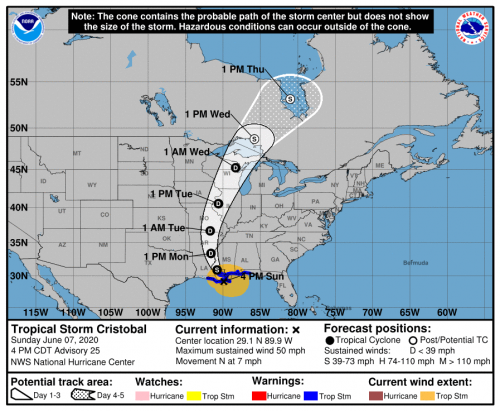
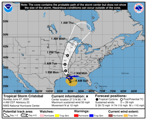
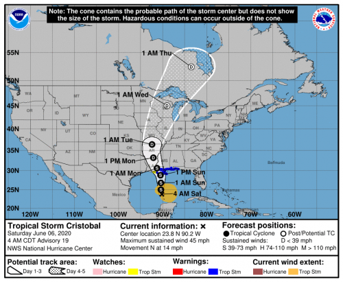
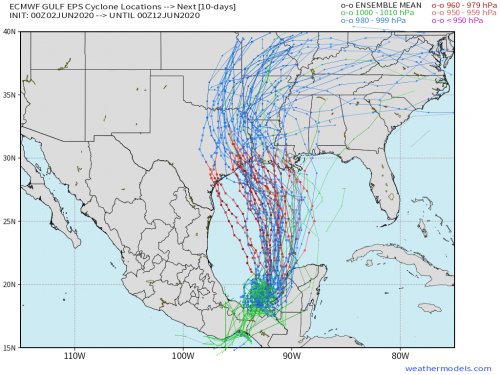
Still trending further east with 4pm advisory
-
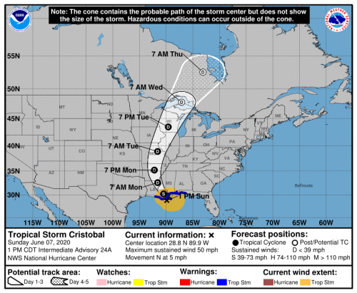
Still trending east little by little:
-
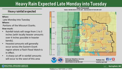
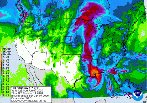
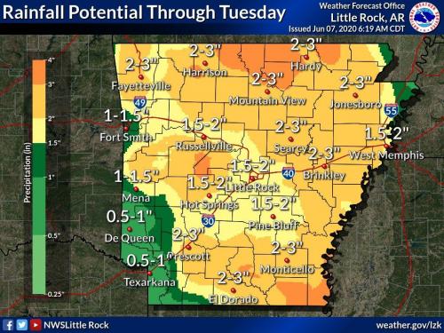
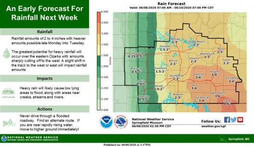
Updated forecast maps: Although not great considering how full the lakes are, max rainfall in the 3" range. A few local amounts up to 6" possible in north central Arkansas and south central MO. A few days ago there was a swath of 4-6" totals in the forecast all the way through central and eastern Arkansas and central MO. I'd put more stock in the local office maps at this juncture to pinpoint more exact areas of rainfall amounts. The 7 day QPF is based entirely on computer models and is a good source for rain potential and areas that will get rain. Pretty good consensus with the local offices
-
More model data here: Also, follow Ryan Maue on twitter.
-
Ok, just go into the trees
-
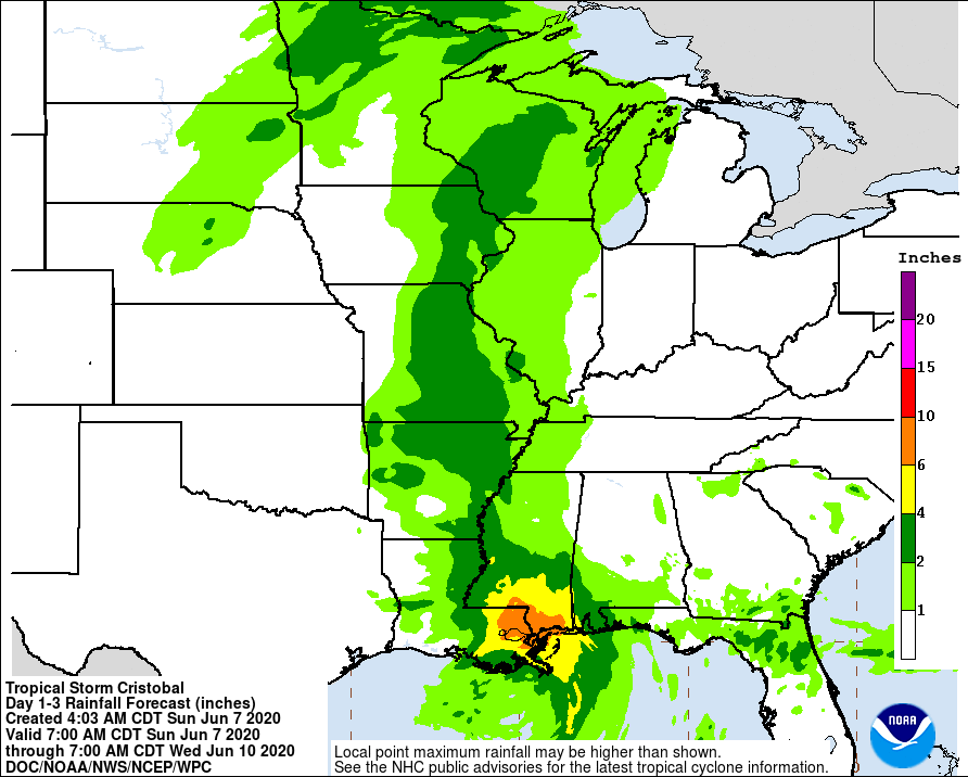
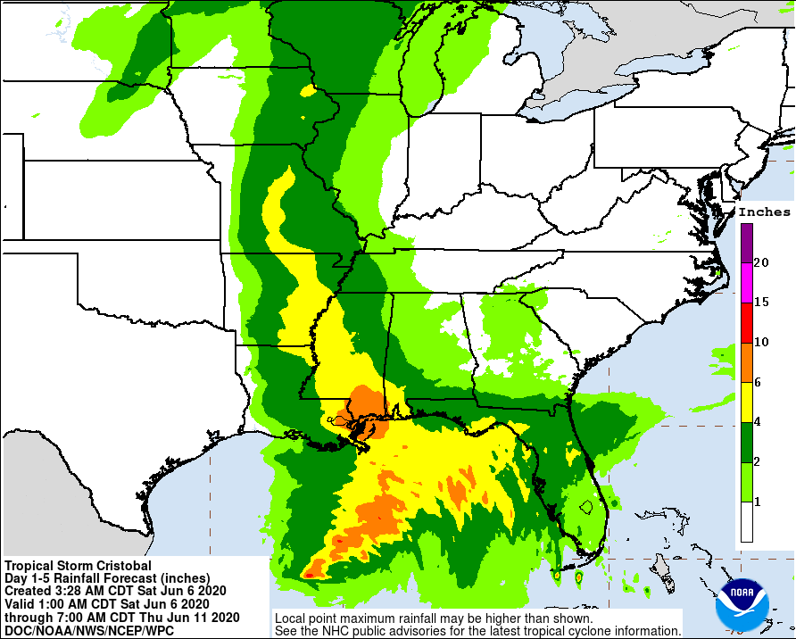
Updated storm track cone and rainfall forecast. Forecast track hasn't changed much for center of circulation. Width of uncertainty just getting smaller. Maybe a slight trend east
-
I'd go past Shell Knob to Big M or Eagle Rock area. Troll or drift (drift sock if wind is right alignment with cove) jigs with 3" grubs or roadrunners in big coves or small tributary arms like Roaring River. When sun goes down tie up to trees in large coves nearest the main lake you can get and use minnows under a bait light.
-

Do I Really Want A Boat?
MickinMO replied to oneshot's topic in Tips & Tricks, Boat Help and Product Review
I'll buy it. Where it at?? -
One good thing is that it at least appears to move fast and not stall out.
-
Pontoon Rebuild Topic
MickinMO replied to Phil Lilley's topic in Tips & Tricks, Boat Help and Product Review
Would rent!!!!!! -
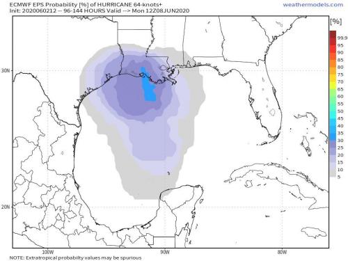
Getting close to a 50/50 chance of it being a hurricane at landfall
-
Hoping for prolonged dry spell. If they are keeping Newport below flood stage don't understand why they wouldn't keep dumping water. Seems like malpractice to hold this much water back and then if the rain returns they would have to double or triple the current flow leading to complete devastation along the whole chain and river. Oh, and a gulf storm is looking more and more likely
-
Bingo. Two lakes become one when Taney tailwater matches Taney elevation
-
Is there a source for Taney tailwater level? BS 695 is downstream at the dam. Would be higher upstream and taney is 702 at powersite dam.
-
Two or three years ago when they were running about 20k cfs we were headed up from Lilleys dock in the morning and started seeing a bunch of stuff floating in the water and a couple of older gentlemen in a pontoon were scooping up what they could with dip nets around the pump house. Didn't think a whole lot of it, but as we continued up lake we kept seeing more tackle and trash. We get up to Trout Hollow and there is a small bass boat about half sunk with the stern up in the air. Luckily, a dock barge was there assisting the fisherman who looked pretty dang scared obviously. Would seem he had tried to anchor up in that eddy across from there, but just was not smart with that much water was running. I don't know if that dock barge just happened to be up there to work on fortifying some docks or what, but that guy was lucky to be alive
-
They have put two or three more wing dikes in on the Missouri that you can see just from the Jeff City bridge in the last few years. Who knows how many that you can't see from the road. All under the guise of deepening the channel. Sorry, but barge traffic between Jeff City and Omaha ain't coming back. The only barges above Jeff City are local sand dredging operations. Jeff City government leaders are trying to establish a port authority thinking that all these barges will start coming up from St Louis. If it was feasible and made money they would never have stopped doing it. Throwing more tax incentives and federal dollars at a ruse.
-
First boat I bought in the 90s was a '78 Ranger with a 115 Evinrude on it. Same model year. We nursed that thing along and kept rpms low based on advice from by buddy's dad. Guy who bought it from us tried to run it all out and blew it up within two weeks. We tried to tell him when he was looking at it because he kept asking how fast it could go. Well, it can go about 45-50 mph, but you want to keep it around 30mph and run a max of 5000 rpms. He didn't take our advice.
-
May 28 - Spill Gate release starts today?
MickinMO replied to Phil Lilley's topic in Upper Lake Taneycomo
Looks like 12000 cfs is essentially going to produce a crest below 932 and will only keep pace with inflow/evaporation. With sun and warmer temps returning to the midwest power demand should be up like normal for this time of year. Was hoping for some over the top like they are doing at Beaver and BSD. Congress and the Corps need to work on a new water control plan for the White. The current policy just ends up making flooding worse for everyone. With all the lakes full another big rain will put central and eastern Arkansas in peril anyways along with everyone else within the chain. I know they ran water all winter, but they should have dumped more. The Corps water policy is like playing russian roulette and mother nature keeps putting extra rounds in the revolver. -
May 28 - Spill Gate release starts today?
MickinMO replied to Phil Lilley's topic in Upper Lake Taneycomo
Maybe we will see a sluice gate release for the first time in like 30 years for Table Rock Dam? -
It's still wrong. They removed the spillway data they were showing last night, but now 705 with only 20cfs release? Don't think so
-
Says gates are open and total CFS release is 17-18,000 the last two hours, but the lake level is only 707? I know the spillway data is a new feature on the app, but something isn't right.
-
One good thing is that there hasn't been a 5-7 inch rain that has covered the entire basin at one time. As mentioned above, there has been some glancing blows, but it's not been a total non-stop deluge. So, it seems they could manage this situation with reasonable flows. Here's to praying for 20k cfs or less out of Table Rock and those downstream in Arkansas who have to deal with the water from all four lakes (5 technically). Pattern appears to turn drier next week. https://www.swl.usace.army.mil/Media/News-Releases/Article/2196761/corps-to-make-spillway-releases-from-white-river-dams/
-
60,000 CFS is a lot of water
-
It appears Beaver did have a problem that they fixed back in the 90s. Too much seepage under the main earthen part that had been a problem since the lake filled. A new secant pile wall had to be constructed. See link below. Interesting read and seems it was an experimental method basically that has worked. These projects take years or even decades to get done. Maybe the new spillway was insurance if Beaver seepage couldn't be fixed or to account for runoff from Springfield. Probably a mix of a lot of things including the idea that engineers just didn't have the data and computer horsepower we do now. I won't talk about computer models, that's a sore subject for me right now. Also fwiw, Ameren UE just finished a $55 million project at Bagnell Dam. Added weight in the form of a bunch of new concrete and more anchors to the dam. Seems like a little more than routine maintenance. https://www.google.com/url?sa=t&source=web&rct=j&url=https://apps.dtic.mil/dtic/tr/fulltext/u2/a303380.pdf&ved=2ahUKEwiljIek8snpAhVIeKwKHYe0DmAQFjADegQIAhAB&usg=AOvVaw2isE5VvWMkkT38WdjIeuYS


