


Flysmallie
-
Posts
9,493 -
Joined
-
Last visited
-
Days Won
83
Content Type
Profiles
Forums
Blogs
Events
Articles
Video Feed
Gallery
Everything posted by Flysmallie
-
There is an issue with pics that Phil is working on.
-
Well crap. Now I gotta get me one of those little fly rods.
-

photo or avatar viewing problems?
Flysmallie replied to BilletHead's topic in Messages for, and from, the Admin
Welcome to the purge!! That probably explains why I couldn't upload a pic a few minutes ago. Hang in there Phil, we will get through it. -
215 is the bridge on 215 Hwy running between Eudora and Morrisville. Closer to Eudora off of 215 you go north on S 60th Rd until it ends then take a right and you are at Taylor.
-
I hardly ever throw a fluke and even less of senkos. And I have caught fish on them. But I think I throw a floating worm almost every time I go fishing. I know it's limiting production but it sure is a hell of a lot of fun.
-
Yep. Just keep thinking that.
-
I guess I better go round up some supplies. People will be sad they didn’t jump in.
-
Well except for that breaking down part. How was the water clarity?
-
You want me just to fix you up a box and we call it good?
-
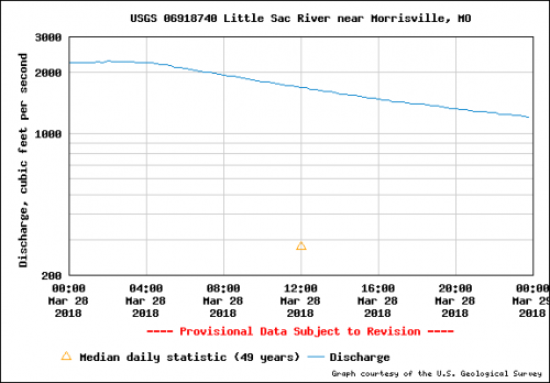
Man that's horrible. Sorry bout that but it gives you an idea of what it looks like at 1,720. Currently it's at 991.
-
You are going to have to excuse the quality of this video. My intentions were to take video of Orleans, Taylor, and 215. Started at Taylor and just as I took off my little bird reminded me that it didn't have a memory card! Well crap. Everything would have to be in lower quality saved to my phone. And then it's been compressed about 57,000 times. Anyway, I only did Taylor and not for very long. This was Wednesday, March 28th, around noon. When I checked cfs on my phone it was 1,720 at 215 bridge.
-
Looks like most silicone based lubricants have a flash point starting around 220 C. 428 F. There are ones with a higher flash point but to answer your question it does ignite.
-
Fly fishing for those golden bones!
Flysmallie replied to MoCarp's topic in General Flyfishing Topics
Probably meant the first Carpapalooza tournament but who knows with today's journalism. -
MoNASP and JOAD are great programs for young archers. It's great seeing it continue to grow.
- 1 reply
-
- 1
-

-
Golden. I have had success both ways but some days that slow, constant, methodical, long drag with the reel can be the ticket. Plus you aren’t going to get caught at the end of that long sweep of the rod with a bite. Sometimes power fishing requires some finesse.
-
That's a long drive.
-
Exactly. My dad always told me not to waste time trying to catch other people's fish. He would, but always pushed me to do something different.
-
Wouldn’t matter if he dropped a pin on a map of the exact location people would still call him a liar. Welcome to today’s America.
-
Good. Maybe it will erase the one of you and Kevin.
-
I've only been on the Big Piney between Dog's Bluff and Slabtown. It's a really nice river. 0.0 Baptist Camp Access. Low-water bridge. No ramp.3.5 Tone Hogan Ford on county road. Access.8.7 Dog’s Bluff Access on left, on Hwy 17.12.4 Brushy Creek on right.13.2 Blankenship Cave in end of bluff on right is merely a rock shelter. This is the Horseshoe Bend area.14.6 Mineral Springs Access on right, off Hwy 63 at Houston, West of Oak Hill Drive, west on Forest Drive and north on Mineral Drive. Mineral Spring 0.5 mile up branch.14.8 Mineral Springs Ford. Access in dry weather.15.3 Cathcart Hollow on right.16.9 Burton Branch on left.18.7 Bell Bluff on left.19.3 Sandy Shoals Ford. Sand Shoals Road connects Hwy. E on the east to Hwy AA on the west.21.5 Arthur Creek on right.24.8 Steam Mill Hollow Creek on left.25.8 Boiling Spring Access on right. Spring is at river level on left and has a flow of about 10 million gallons a day. Private campground. A good road crosses the river here on a concrete lowwater “bridge.” This is a local swimming hole. River quite slow from here to Hwy. 32.27.7 Narrow Gap Bluff on left.29.0 Burnett Spring on left.29.8 Boone Creek on right.31.8 Mason Bridge Access on right on Mason Bridge Road. Gravel ramp.34.9 Falling Springs up right bank.36.1 Hazelton Spring, off river to left, is not open to public. Site of old grist mill. Private access on right.38.8 Paddy Creek on left. U.S. Forest Service campground one mile up creek.39.8 Forest Service Slabtown access and camp.40.8 Slabtown Spring branch enters on right but is posted.44.7 Blooming Rose Camp.46.7 National Forest camp and access at Horse Camp on left.50.0 Six Crossings. Not public access.52.2 Pine Bluff on right is more than 200 feet tall.52.7 A pipe crosses the river bottom at right angles to the current sometimes causing a roller wave, but paddle boats go over it easily. just downstream, on left is the mouth of Bald Ridge Hollow and a road.54.7 Ross Access on right, just below Ross bridge. This is last practical take-out before entering Fort Leonard Wood. Gravel access.57.7 Miller Spring Branch on left. The spring, 0.3 mile up the branch, is an ebbing-andflowing spring, of which there are few in Missouri. The rate of flow may fluctuate from 5 million gallons to two or three times that much during a single day.59.9 Enter military reservation. Both sides of the river are within Fort Wood from here to mile 60.2.61.8 Low rock dam at water plant intake. Do not run in boat! Portage.61.9 Concrete bridge to golf course on right, and other post recreation areas.64.7 Stone Mill Spring and Officer’s Picnic Area on right. The spring’s flow is around 10 million gallons a day.66.2 Concrete dam backs up water for about a mile. Channel cuts around dam to left. Dangerous obstructions! Portage. Use caution.66.5 Bridge. Good access with limited parking on right bank. East Gate Fort Wood Campground on left bank.66.8 National Forest access on right bank.68.9 Leave reservation. Land on left is still within reservation.69.3 Spring Creek enters on right.69.6 Hwy. J parallels river on right along Spring Creek Bluff.80.0 Shanghai Spring (Blue Spring), 500 feet up branch at left, is comparable in size to the other large springs along the Piney. The spring is on private grounds but may be viewed from the road.81.4 Army railroad bridge.82.4 Hwy. V Bridge. Devil’s Elbow. No access.82.9 Old Hwy. 66 bridges. Private access on left bank below bridge.83.2 1-44 bridges. No access.85.7 Junction with Gasconade River. Private access on right. Lodging, refreshments and parking available.
-
Farthest I ever heard was O Hwy. But that was a long time ago. I have fished for them at 111 with zero success. Never fished around 550. 215 is the fartheset i have done any good but I've seen people walk up from there and catch good numbers. It all depends on the water and a fish that nobody truly understands.
-
That makes sense. I drove over it a Sunday and it looked really good there. Could use a little more water though.
-
There is plenty of water to do 215 to Taylor right now. It's higher now than it was last year when I did it.
-
Well it's kind of ridiculous actually. But it's no different than everything else on the planet needing a name. Most of the flies in my box don't have a name. Or they have a really weird name for some reason that nobody ever hears. But this Mr. Ness guy is running a tight ship on this train wreck so I posted up some names. We'll thank Jack for the gurgler name, even though he might not like my version. I explained the name of the marabou pig, kind of. And the trashy dragon I just pulled out of the air but it will make since when you see it. And it sure as hell isn't an f'ing nymph.


