

Quillback
-
Posts
19,853 -
Joined
-
Last visited
-
Days Won
341
Content Type
Profiles
Forums
Blogs
Events
Articles
Video Feed
Gallery
Everything posted by Quillback
-
I was using Sunline SX1 in chartreuse 16 lb., first time with it. So far I can say that it casts well and I didn't have any noticeable color bleed on the line. I like the high visibility too. If I do experiment with straight braid to the jighead I will probably follow Royal Blue's suggestion and black out the first 3 feet. Or go to a stealthy color in small diameter. Just wish this stinking weather would stabilize a bit so I can get out on the water more.
-
Had an early morning DR's appointment (annual checkup), so didn't get to the lake until 1130. Wind was cranking when I got there, much windier than I expected, probably would've stayed home if I had known how windy it was, but I was there so put the boat in the water and headed out. The bite was decent, I caught 14 bass, all between 12-15 inches, mix of largemouth and spots with 2 meanmouth. All on the Ned, fish were in the 10-20 foot range as far as depth. I packed it in after 4 hours, just got tired of fighting that wind. Would've been a good day to have an Ultrex. Tried new rigging for my Ned fishing. First 4 bass I caught on my standard 6 lb. InvisX, had another rod rigged with braid, fluoro leader, and a Nutech crappie jig as the jig head for the cut Zinker. Caught my last 10 bass on that setup. I liked it, the braid will outcast my InvisX set up by easily 10-20 feet, and it really magnifies the bite, you can really feel it. Helped a lot fishing in that wind. Didn't break off that Nutech head, liked that too. WT 45
- 14 replies
-
- 16
-

-
I fished Beaver on the lower end quite a bit last spring for smallmouth, used the Keitechs a lot, I am going to estimate that between me and whoever was fishing with me, we put maybe 12 keeper sized walleye in the boat. Didn't catch them every time and we weren't targeting them, but they did seem to like that keitech.
-
I'm partial to Rainbow Shad myself, but agree with Bferg that if it's shad like, they'll bite it. Electric Blue - Chartreuse works well for small mouth, they seem to like those bright colors. I use 2.8 on a 1/8 oz head, 3.3 on 1/4 oz and 3/8 for the 3.8.
-
Sorry to hear you won't make it Rick, we'll catch you on the next one!
-
Trout opener article in the St Louis Post
Quillback replied to snagged in outlet 3's topic in Trout Talk
Add to that balls of line thrown into the lake or stream, there's a persistent myth that fishing line is biodegradable. -
Everybody complains the youth of America are being corrupted by overuse of video games and social media, but look what they do when they have free time otherwise..😄
-
I take a couple of Ibuprofen before I leave the house on fishing days. We all have to be careful not to "graduate" to opiod painkillers.
-
2019 Official Ozark Anglers BASS Fantasy Fishing League
Quillback replied to abkeenan's topic in Table Rock Lake
Thanks for the reminder, didn't know they were going again this week. -
I never thought of that, but I would think it's a real possibility. As far as I know it is not against the rules. If so, he needs to let us know, I'm only 10 years behind him, I'm going to need what he's taking. 🙂
-
Tough for guys in their 70's to fish for 4 straight days, 4 long days at that.
-
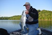
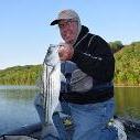
Very nice, that is one FAT striper!
-
2019 Official Ozark Anglers BASS Fantasy Fishing League
Quillback replied to abkeenan's topic in Table Rock Lake
I got nobody today. I seem to have a knack for picking guys that do OK on day one, then slowly move down in the standings over the last three days. -
OA One Bass Tournament March 23, Eagle Rock
Quillback replied to Quillback's topic in Table Rock Lake
Looks like we have burgers, bologna, the plastic ware and plates, some buns, dogs and I think that is it so far. We'll need some sodas and water, side dishes, so you can pick which of these you want to bring, if any, no requirement to bring anything, but contributions are appreciated. -
OA One Bass Tournament March 23, Eagle Rock
Quillback replied to Quillback's topic in Table Rock Lake
didn't you bring burgers a couple of years ago? That would be good if you want to bring them again. -
OA One Bass Tournament March 23, Eagle Rock
Quillback replied to Quillback's topic in Table Rock Lake
Yep, you're a member, look forward to seeing you there! -
Haven't tried them but I bet they will work. Z-man makes so much stuff now, no time to fish it all.
-
Ok, booked the River Villa as well. We may be getting a couple of more people too, so we'll need the room. Michelle told me they are adding another bathroom to the Villa and it should be done by the time we get there. I am reserving a place for myself at the Cedar Gables in the 1st bedroom on the right, as I am bringing the pooch and River Villa is a no go for dogs.
-
That's because you're sore-lipping them all! 🙂 Rigged a couple of tubes using bell sinkers like you mentioned, works out well, looking forward to some decent weather to try then out, I think they will work well.
-
My favorite are summer run steelhead, when I fished for them in Washington state. Very hard fighters, very acrobatic and a challenging fish to catch which makes it very rewarding when you do catch one. At one time my plan was to retire up there and be a full time steelhead bum, but the runs have declined to the point where I doubt I'll ever go back to fish for them. I'll just have to be satisfied with some great memories. So for now, my favorite are smallmouth bass, I love catching a 3lb. smallie on top water, or on light tackle like the ned rig.
-
Are you near Springfield? If someone is coming down from that general direction maybe they could swing by and pick you up, if not I can drive up there and get you.
-
Some interesting stuff, I haven't watched the entire thing, it runs an hour. Some interesting stuff concerning bass/crappie and fluctuating water levels. Wrench - It's a biologist presenting it, you probably don't want to watch. 🙂
-
- 4
-
-
I've got a milk run set up, based on 10 years of fishing the Big M area in the winter. Usually I can find some fish on one of my milk run spots. Tuesday I found a bunch in a couple of locations where I hadn't had much luck so far this year. The fish just seemed to have showed up on those spots, don't know if it was some kind of pre-pre-spawn thing or maybe had to do with craws getting out. If those 2 spots had not held fish, it would have been a tough day. And as Bo says, it's fishing small, it's real easy to get on empty water, gotta keep looking for fish if you aren't on them. I have a lot of faith in the Ned rig right now, I've been fishing it real slow, but it seems if there are fish around they'll eat it. Jerk bait bite has been an early thing, I can't catch them on it after the first hour in the morning.
-
I'll have to check the fabric dept., maybe they have them there.
-
My local WW stopped carrying Fiskars a while back, wished I had caught that sale, 99 cents is dirt cheap.


