

Quillback
-
Posts
19,856 -
Joined
-
Last visited
-
Days Won
342
Content Type
Profiles
Forums
Blogs
Events
Articles
Video Feed
Gallery
Everything posted by Quillback
-
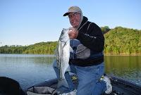
From the album: Jeff's other pics
-
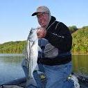
From the album: Jeff's other pics
-
Went fishing myself today, haven't caught any coverage yet, might get some time to watch tomorrow if they are able to fish.
-
65 year old male. From the police report: SUBJECT WAS PADDLING HIS BOAT DUE TO ENGINE FAILURE, FELL OUT OF THE BOAT, AND DROWNED. Be careful out there folks, wear that life jacket.
-
Congratulations!
-
Sorry to hear this, I always enjoyed reading his posts.
-
Good to see you get that dog!
-
Kim City - April 27 - Swimbait and underspin
Quillback replied to Dock-in-it's topic in Table Rock Lake
That is one big ol' largemouth! -
Caught some bank running males, 3 keepers total. Ned rigs right up on the bank, buck brush banks were the best. Saw some fish on beds in one pocket that had water running into it. WT59-60.
- 1 reply
-
- 10
-

-
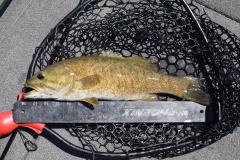
Caught this 4.25 pound smallie April 24
Quillback replied to snagged in outlet 3's topic in Smallmouth Talk
Great fish! -
New PB spotted bass on the Rock. Any ideas on weight
Quillback replied to Jozark's topic in Table Rock Lake
Nice looking healthy fish, congrats! -
Area round Murfreesboro looks interesting - never have been there, but you've got DeGray, Blue Mountain, and Millwood relatively close. Winters are a bit warmer too than what you get up here near the MO border.
-
Yeah I tell ya, the Mountain Home area is looking better all the time. Plus you've got some great trout fishing on top of being close to Bull and Norfolk. For right now I have reasons for staying where I am, but a few years down the road I may move on.
-
I have gone to braid/leader on my spinning setups, except for tossing moving baits. I like Seaguar Smackdown. It's just right for tying braid to leader knots in that is not too stiff or too supple and works well for me - but that is a personal preference, may not work for you. I get the high viz version, it holds the color well, it will fade over time, but it hasn't gotten white after a day of use like some of the other brands I have tried. It's not cheap, $30 a spool, but it lasts forever. Bo could make straight braid work, I have tried it, I caught fish, but it would always get frayed, fairly quickly, and on about hookset 3 or 4, would just break, so I stick with a leader. I've tied so many braid to leader knots that it is not a big deal to tie one. I think the knot I use is the Alberto knot, 10 wraps one way, than back over the 10 wraps with 4 or 5 wraps. A lot of people like Suffix 832, certainly worth a shot. FWIW, I use 15 lb. braid and 10 lb. leader for finesse stuff. Distance is not an issue.
-
Got an early start to beat the wind. Had some really good fishing for a couple of hours off a couple of gravel points. The bass were shallow early, from 3 feet out to 10 feet. Neds and 2.8 Keitechs. Bites were about equal between the 2 baits, but I missed more bites on the Keitech for some reason. I should've stayed in the area of those points, but had to go try some other spots, and when I did that, things got tough. Then the wind started howling and things got even tougher. Could not get bit on the moving baits and the wind made it tough to fish the finesse stuff. Had enough of the wind and left at 1130. Caught 19 bass, three were keepers, 4 short walleye, a couple of whites and a chunky crappie. WT 59. Lots of boats and a couple of yaks.
-
- 9
-
-
Lot of boats, and it's Friday - just wait until tomorrow. FWIW, tomorrow I'll be doing some garden stuff. Big M lot - 18 rigs, which is a lot for a Friday.
-
Yeah those orange flags are hard to see and if the wind's blowing the right way, nearly invisible. Kayaks are just tough to see from a bass boat, there's no way around it.
-
Big kayak tourney this weekend, going to be some strong winds according to the forecast. Those yaks can be hard to see if they are out in the chop. Keep an eye out for them. Joplin kayaker reported missing by family drowns on Table Rock Lake (news-leader.com)
-
If they are looking for a stud for their dog, the one my BIL uses is supposed to have all the right stuff for a family type lab. I think, but not sure, the stud lives somewhere near the Cape so it would be a bit of a haul from Beverly.
-
That's interesting, my sister and BIL have had Labs for years and have litters of pups to sell almost every year. They have never mentioned having any pressure to get their dogs spayed, but I'll have to ask them. They live in Wrentham MA. As far as demand, they are all sold before they are weaned, I think the get around $1K per pup.
-
I will do a 2-3 AM start in the summer a couple of times on one of the BV lakes in the summer, so it's dark, but more of a pre-dawn thing. I've caught a few decent fish doing that, but not the last couple of years. I go for broke and throw big stuff, Ol' Monster, 3/4 oz jig, black spinner bait with a #5 willow blade, wobble head with a creature. I'd like to fish TR at night, but it's just too far to drive when I'm half asleep. And to your point there's the learning curve on top of that.
-
LOL, yeah do 70 (the speed limit) on I-49 here in NWA and you'll be left in the dust.
-
Hauled the boat over today thinking I was going to whack them. Got off to a slow start, cloudy, cold north wind blowing, the fish were pretty tight lipped and it took a while to start getting some bites. The ones that I could catch were really shallow, usually around buck brush or off gravel with wind. Caught fish on the 2.8 Keitech and 1/8 oz Ned. 22 bass (3 keepers) and one keeper wallie. Water going either way out of Big M is stained pea green or brown. Looks pretty good. WT 54. If I could do it over again, I would come armed with shallow cranks, #5 Shad Rap, DT6, something I could run shallow.
- 1 reply
-
- 7
-
-
Spring Shad run and a Surprise!
Quillback replied to Johnsfolly's topic in U.S.A. - North & East Regions
Are the runs in trouble in MD? Just curious why they don't allow any retention.


